
Hello, I use to color maps by scrap altitude. Lately I noticed Therion color gradient starts from 0 m altitude to maximum cave altitude. Because caves don't reach 0 m almost all color range is unused and most scraps are colored with similar colors. If I remember correctly some time ago Therion used all color range because color gradient extended from minimum cave altitude (not 0 m) to maximum. Am I missing something? Is there a way to use all available colors? Thanks, Marco

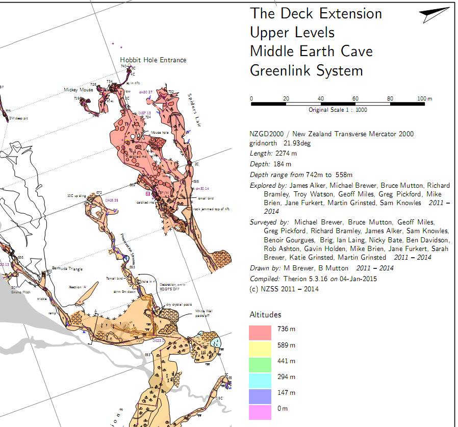
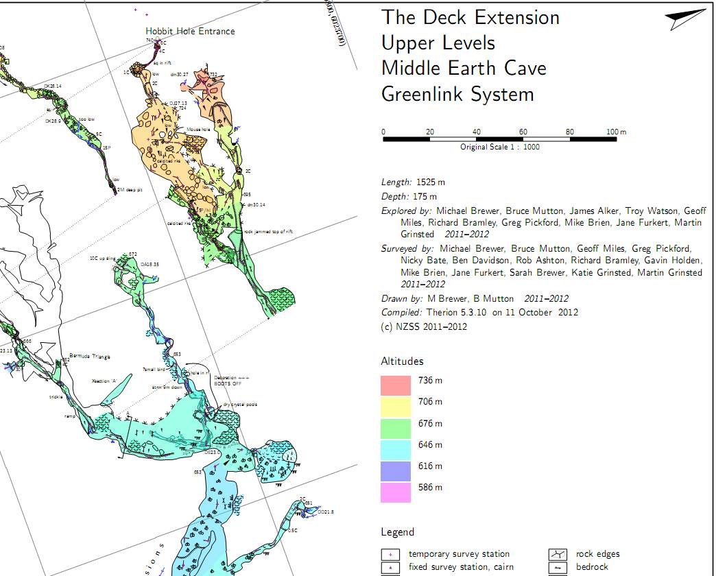
Hmm, seems like there is an issue here. Comparing 5.3.12 map with 5.3.16 map as attached. Not sure if it might be a side effect of something else, as I think the colour range is OK sometimes (I think I noticed some irregularities with 5.3.15 but assumed I was imagining things at the time) - maybe the preview below triggers it? - I might investigate further if I get time. Bruce _____ From: therion-bounces@speleo.sk [mailto:therion-bounces@speleo.sk] On Behalf Of Marco Menchise Sent: Saturday, 3 January 2015 8:45 a.m. To: List for Therion users Subject: [Therion] Altitude colors range Hello, I use to color maps by scrap altitude. Lately I noticed Therion color gradient starts from 0 m altitude to maximum cave altitude. Because caves don't reach 0 m almost all color range is unused and most scraps are colored with similar colors. If I remember correctly some time ago Therion used all color range because color gradient extended from minimum cave altitude (not 0 m) to maximum. Am I missing something? Is there a way to use all available colors? Thanks, Marco
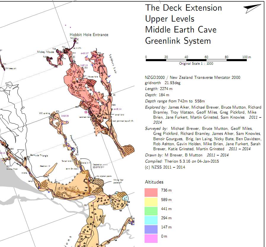
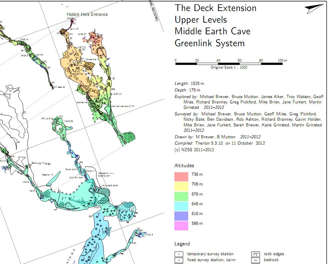
OK, the problem is not the previews or the offsets, as it occurs in the map examples below regardless of presence of previews or offsets. What does seem to control whether the altitudes start at zero meters is whether the map definition includes a survey centerline. If part of map definition includes a survey centerline, then altitudes are coloured from zero meters to survey maxima (a bug?). If map definition has no survey centerline as part of it's definition, then coloured from survey minima to survey maxima (correct behaviour). Hence I find this behaviour manifests in maps in progress, but when they are finished and I (usually) turn off the centerline maps, they correct themselves. Bruce _____ From: therion-bounces@speleo.sk [mailto:therion-bounces@speleo.sk] On Behalf Of Bruce Sent: Sunday, 4 January 2015 10:42 a.m. To: 'List for Therion users' Subject: Re: [Therion] Altitude colors range Hmm, seems like there is an issue here. Comparing 5.3.10 map with 5.3.16 map as attached. Not sure if it might be a side effect of something else, as I think the colour range is OK sometimes (I think I noticed some irregularities with 5.3.15 but assumed I was imagining things at the time) - maybe the preview below triggers it? - I might investigate further if I get time. Bruce _____ From: therion-bounces@speleo.sk [mailto:therion-bounces@speleo.sk] On Behalf Of Marco Menchise Sent: Saturday, 3 January 2015 8:45 a.m. To: List for Therion users Subject: [Therion] Altitude colors range Hello, I use to color maps by scrap altitude. Lately I noticed Therion color gradient starts from 0 m altitude to maximum cave altitude. Because caves don't reach 0 m almost all color range is unused and most scraps are colored with similar colors. If I remember correctly some time ago Therion used all color range because color gradient extended from minimum cave altitude (not 0 m) to maximum. Am I missing something? Is there a way to use all available colors? Thanks, Marco
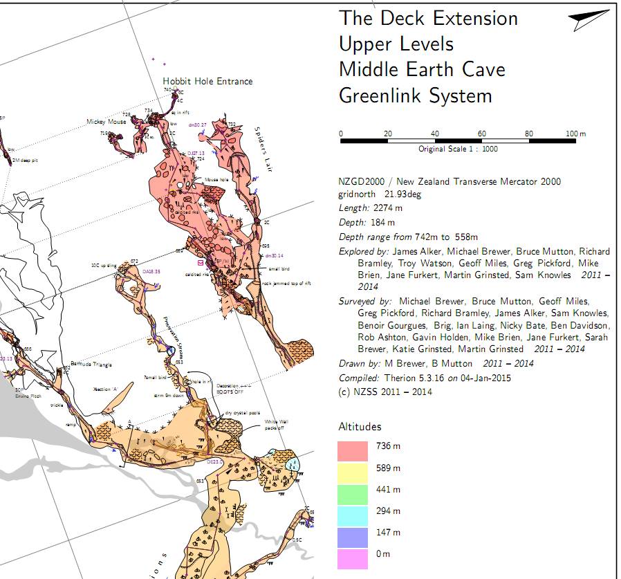
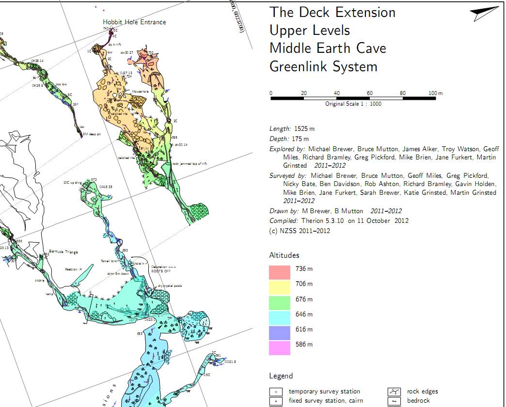

If someone is working on this area, then it would be good to allow the minimum and maximum altitude to be used for the colour range to be specified in maps. I currently do this via a hack in my maps, including a scrap containing two artificial fixed survey stations at the min. and max. altitudes I want the map to use for colouring. Provided the rest of the scraps in the map are in this range then the entire map is coloured the same regardless of which scraps I include. So I can generate a map of part of the cave with the same colours as the map of the entire cave. Otherwise maps of small areas of the cave get coloured with very different scrap colours due to the small altitude range of the scraps in the map. Footleg On 5 January 2015 at 22:40, Bruce <bruce@tomo.co.nz> wrote:
OK, the problem is not the previews or the offsets, as it occurs in the map examples below regardless of presence of previews or offsets.
What does seem to control whether the altitudes start at zero meters is whether the map definition includes a survey centerline.
If part of map definition includes a survey centerline, then altitudes are coloured from zero meters to survey maxima (a bug?).
If map definition has no survey centerline as part of it’s definition, then coloured from survey minima to survey maxima (correct behaviour).
Hence I find this behaviour manifests in maps in progress, but when they are finished and I (usually) turn off the centerline maps, they correct themselves.
Bruce
------------------------------
*From:* therion-bounces@speleo.sk [mailto:therion-bounces@speleo.sk] *On Behalf Of *Bruce *Sent:* Sunday, 4 January 2015 10:42 a.m. *To:* 'List for Therion users' *Subject:* Re: [Therion] Altitude colors range
Hmm, seems like there is an issue here.
Comparing 5.3.10 map with 5.3.16 map as attached.
Not sure if it might be a side effect of something else, as I think the colour range is OK sometimes (I think I noticed some irregularities with 5.3.15 but assumed I was imagining things at the time) – maybe the preview below triggers it? - I might investigate further if I get time.
Bruce
------------------------------
*From:* therion-bounces@speleo.sk [mailto:therion-bounces@speleo.sk] *On Behalf Of *Marco Menchise *Sent:* Saturday, 3 January 2015 8:45 a.m. *To:* List for Therion users *Subject:* [Therion] Altitude colors range
Hello,
I use to color maps by scrap altitude.
Lately I noticed Therion color gradient starts from 0 m altitude to maximum cave altitude. Because caves don't reach 0 m almost all color range is unused and most scraps are colored with similar colors. If I remember correctly some time ago Therion used all color range because color gradient extended from minimum cave altitude (not 0 m) to maximum.
Am I missing something? Is there a way to use all available colors?
Thanks,
Marco
_______________________________________________ Therion mailing list Therion@speleo.sk http://mailman.speleo.sk/mailman/listinfo/therion
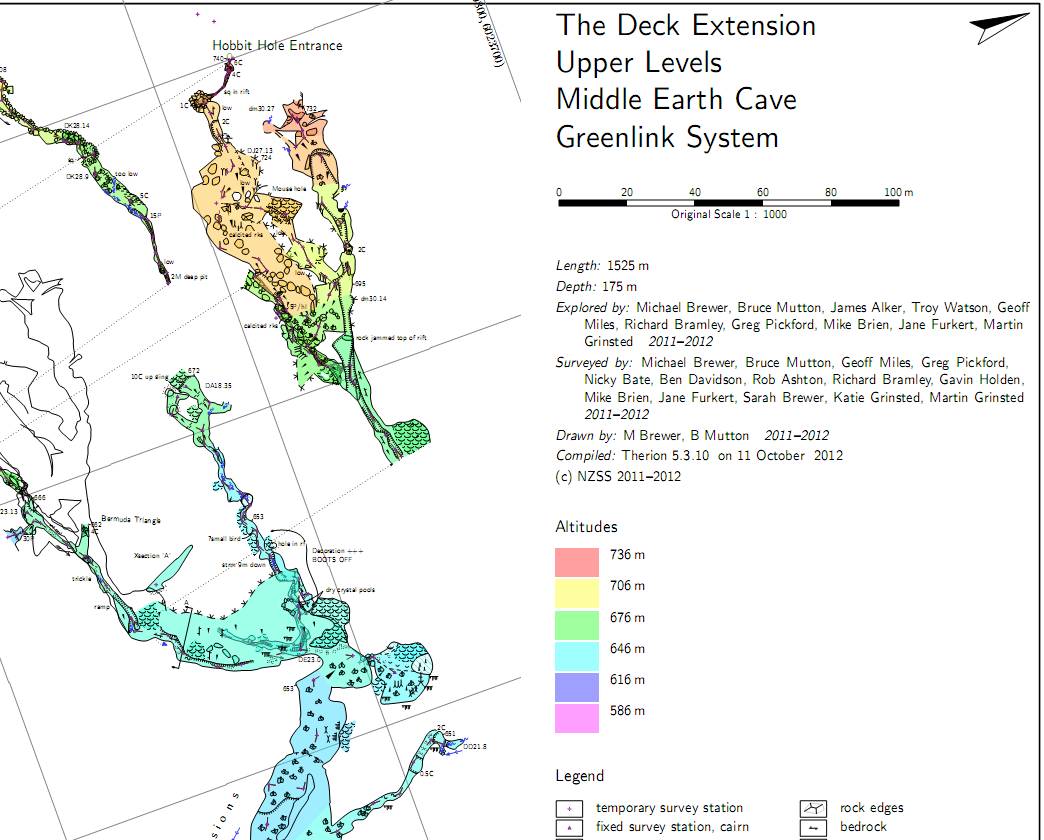
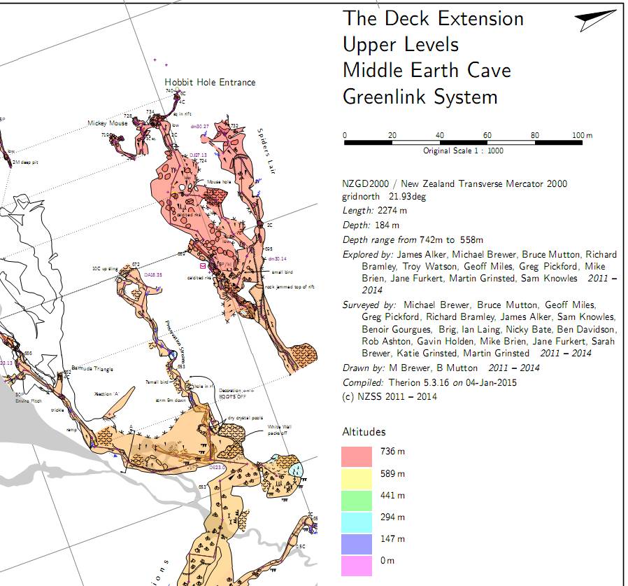
I am not seeing this Bruce. I just tested with 5.3.16. My survey imports the centreline from a Survex .3d file however, so that might make a difference? Or maybe I am not understanding what you mean by including the centreline in the map. I turned off the centreline using 'symbol-hide line survey'. If I comment that out in my layout then the centreline is drawn in the map, but my altitude range still covers only the range of my scraps. Footleg On 5 January 2015 at 22:40, Bruce <bruce@tomo.co.nz> wrote:
OK, the problem is not the previews or the offsets, as it occurs in the map examples below regardless of presence of previews or offsets.
What does seem to control whether the altitudes start at zero meters is whether the map definition includes a survey centerline.
If part of map definition includes a survey centerline, then altitudes are coloured from zero meters to survey maxima (a bug?).
If map definition has no survey centerline as part of it’s definition, then coloured from survey minima to survey maxima (correct behaviour).
Hence I find this behaviour manifests in maps in progress, but when they are finished and I (usually) turn off the centerline maps, they correct themselves.
Bruce
------------------------------
*From:* therion-bounces@speleo.sk [mailto:therion-bounces@speleo.sk] *On Behalf Of *Bruce *Sent:* Sunday, 4 January 2015 10:42 a.m. *To:* 'List for Therion users' *Subject:* Re: [Therion] Altitude colors range
Hmm, seems like there is an issue here.
Comparing 5.3.10 map with 5.3.16 map as attached.
Not sure if it might be a side effect of something else, as I think the colour range is OK sometimes (I think I noticed some irregularities with 5.3.15 but assumed I was imagining things at the time) – maybe the preview below triggers it? - I might investigate further if I get time.
Bruce
------------------------------
*From:* therion-bounces@speleo.sk [mailto:therion-bounces@speleo.sk] *On Behalf Of *Marco Menchise *Sent:* Saturday, 3 January 2015 8:45 a.m. *To:* List for Therion users *Subject:* [Therion] Altitude colors range
Hello,
I use to color maps by scrap altitude.
Lately I noticed Therion color gradient starts from 0 m altitude to maximum cave altitude. Because caves don't reach 0 m almost all color range is unused and most scraps are colored with similar colors. If I remember correctly some time ago Therion used all color range because color gradient extended from minimum cave altitude (not 0 m) to maximum.
Am I missing something? Is there a way to use all available colors?
Thanks,
Marco
_______________________________________________ Therion mailing list Therion@speleo.sk http://mailman.speleo.sk/mailman/listinfo/therion
I checked and I can confirm what Bruce is saying. If you don't include centerline in map, the altitude range is correct. If you hide the centerline in the layout (leaving it in the map) the altitude range keeps starting from 0 m. Marco On Wed, Jan 7, 2015 at 2:52 PM, Footleg <drfootleg@gmail.com> wrote:
I am not seeing this Bruce. I just tested with 5.3.16. My survey imports the centreline from a Survex .3d file however, so that might make a difference? Or maybe I am not understanding what you mean by including the centreline in the map. I turned off the centreline using 'symbol-hide line survey'. If I comment that out in my layout then the centreline is drawn in the map, but my altitude range still covers only the range of my scraps.
Footleg
On 5 January 2015 at 22:40, Bruce <bruce@tomo.co.nz> wrote:
OK, the problem is not the previews or the offsets, as it occurs in the map examples below regardless of presence of previews or offsets.
What does seem to control whether the altitudes start at zero meters is whether the map definition includes a survey centerline.
If part of map definition includes a survey centerline, then altitudes are coloured from zero meters to survey maxima (a bug?).
If map definition has no survey centerline as part of it’s definition, then coloured from survey minima to survey maxima (correct behaviour).
Hence I find this behaviour manifests in maps in progress, but when they are finished and I (usually) turn off the centerline maps, they correct themselves.
Bruce
------------------------------
*From:* therion-bounces@speleo.sk [mailto:therion-bounces@speleo.sk] *On Behalf Of *Bruce *Sent:* Sunday, 4 January 2015 10:42 a.m. *To:* 'List for Therion users' *Subject:* Re: [Therion] Altitude colors range
Hmm, seems like there is an issue here.
Comparing 5.3.10 map with 5.3.16 map as attached.
Not sure if it might be a side effect of something else, as I think the colour range is OK sometimes (I think I noticed some irregularities with 5.3.15 but assumed I was imagining things at the time) – maybe the preview below triggers it? - I might investigate further if I get time.
Bruce
------------------------------
*From:* therion-bounces@speleo.sk [mailto:therion-bounces@speleo.sk] *On Behalf Of *Marco Menchise *Sent:* Saturday, 3 January 2015 8:45 a.m. *To:* List for Therion users *Subject:* [Therion] Altitude colors range
Hello,
I use to color maps by scrap altitude.
Lately I noticed Therion color gradient starts from 0 m altitude to maximum cave altitude. Because caves don't reach 0 m almost all color range is unused and most scraps are colored with similar colors. If I remember correctly some time ago Therion used all color range because color gradient extended from minimum cave altitude (not 0 m) to maximum.
Am I missing something? Is there a way to use all available colors?
Thanks,
Marco
_______________________________________________ Therion mailing list Therion@speleo.sk http://mailman.speleo.sk/mailman/listinfo/therion
_______________________________________________ Therion mailing list Therion@speleo.sk http://mailman.speleo.sk/mailman/listinfo/therion
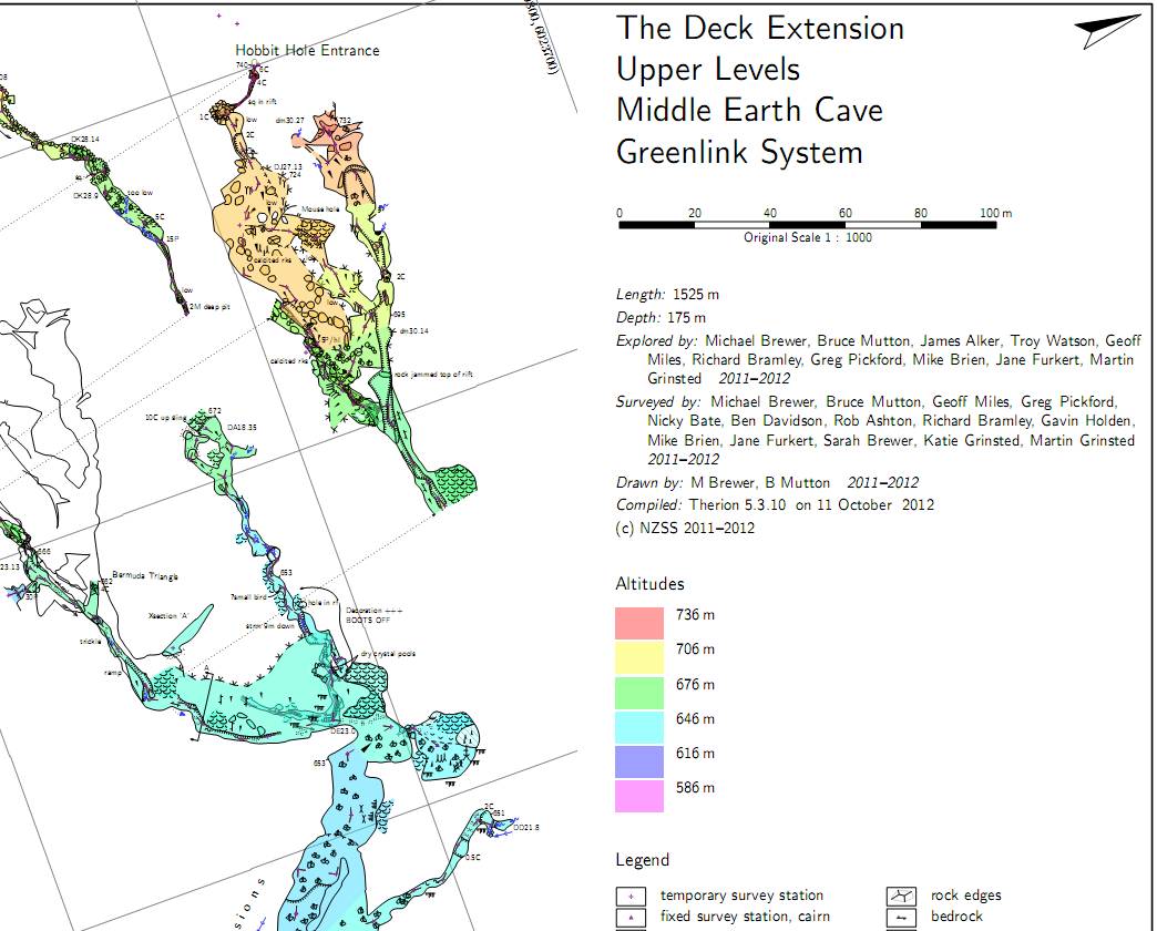
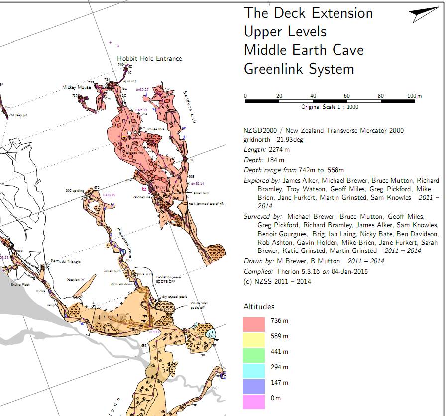
Or maybe I am not understanding what you mean by including the centreline in the map
Like this map DeckExtensionPlanMap -title "The Deck Extension<br>Upper Levels<br>Middle Earth Cave<br>Greenlink System" . 36-BigWednesdayPlan@MiddleEarth 36-BigWednesdayPlanCL@MiddleEarth . end map where the contributory maps look like this. map 36-BigWednesdayPlanCL -title "36-BigWednesday centreline Plan" -projection plan 36 #centreline survey endmap map 36-BigWednesdayPlan -title "36-BigWednesday Plan" -projection plan 36-BigWednesdayPlan-s1 #scraps 36-BigWednesdayPlan-s2 endmap So what it is looking like, if the contributory maps are all derived from scraps (or maps in turn derived from scraps), then the altitude range is correct. But if there is a map that is centerline derived (ie has no scraps) then the altitude minima is set to zero. One other thing. All my tests so far use survex for loop closure. I have not tried using Therion loop closure. And all my files are native Therion files - no survex imports. Bruce _____ From: therion-bounces@speleo.sk [mailto:therion-bounces@speleo.sk] On Behalf Of Marco Menchise Sent: Thursday, 8 January 2015 3:05 a.m. To: List for Therion users Subject: Re: [Therion] Altitude colors range I checked and I can confirm what Bruce is saying. If you don't include centerline in map, the altitude range is correct. If you hide the centerline in the layout (leaving it in the map) the altitude range keeps starting from 0 m. Marco On Wed, Jan 7, 2015 at 2:52 PM, Footleg <drfootleg@gmail.com> wrote: I am not seeing this Bruce. I just tested with 5.3.16. My survey imports the centreline from a Survex .3d file however, so that might make a difference? Or maybe I am not understanding what you mean by including the centreline in the map. I turned off the centreline using 'symbol-hide line survey'. If I comment that out in my layout then the centreline is drawn in the map, but my altitude range still covers only the range of my scraps. Footleg On 5 January 2015 at 22:40, Bruce <bruce@tomo.co.nz> wrote: OK, the problem is not the previews or the offsets, as it occurs in the map examples below regardless of presence of previews or offsets. What does seem to control whether the altitudes start at zero meters is whether the map definition includes a survey centerline. If part of map definition includes a survey centerline, then altitudes are coloured from zero meters to survey maxima (a bug?). If map definition has no survey centerline as part of it's definition, then coloured from survey minima to survey maxima (correct behaviour). Hence I find this behaviour manifests in maps in progress, but when they are finished and I (usually) turn off the centerline maps, they correct themselves. Bruce

7. 1. 2015 v 19:41, Bruce <bruce@tomo.co.nz>:
So what it is looking like, if the contributory maps are all derived from scraps (or maps in turn derived from scraps), then the altitude range is correct. But if there is a map that is centerline derived (ie has no scraps) then the altitude minima is set to zero.
Only one question: do you have defined entrance? m.
7. 1. 2015 v 19:41, Bruce <bruce@tomo.co.nz>:
So what it is looking like, if the contributory maps are all derived from scraps (or maps in turn derived from scraps), then the altitude range is correct.
But if there is a map that is centerline derived (ie has no scraps) then the altitude minima is set to zero.
Only one question: do you have defined entrance?
Yes, the survey network has a number of entrances defined. One of which is present in the exported map I was experimenting with. Bruce
I see it too now. I have not realised you could include just a centreline in the map. It shows every survey station and leg in the cave, rather than just those included in scraps right? When I add that my altitude baseline is set to 0m like yours using 5.3.16 I've not done this before as I had assumed I could only see survey sections which were drawn in scraps. I can see how it is useful to be able to render centrelines and stations for the entire system regardless. Footleg On 7 January 2015 at 18:41, Bruce <bruce@tomo.co.nz> wrote:
Or maybe I am not understanding what you mean by including the centreline in the map
Like this
map DeckExtensionPlanMap -title "The Deck Extension<br>Upper Levels<br>Middle Earth Cave<br>Greenlink System"
…
36-BigWednesdayPlan@MiddleEarth
36-BigWednesdayPlanCL@MiddleEarth
…
end map
where the contributory maps look like this…
map 36-BigWednesdayPlanCL -title "36-BigWednesday centreline Plan" -projection plan
36 #centreline survey
endmap
map 36-BigWednesdayPlan -title "36-BigWednesday Plan" -projection plan
36-BigWednesdayPlan-s1 #scraps
36-BigWednesdayPlan-s2
endmap
So what it is looking like, if the contributory maps are all derived from scraps (or maps in turn derived from scraps), then the altitude range is correct.
But if there is a map that is centerline derived (ie has no scraps) then the altitude minima is set to zero.
One other thing.
All my tests so far use survex for loop closure. I have not tried using Therion loop closure.
And all my files are native Therion files – no survex imports.
Bruce
________________________________
From: therion-bounces@speleo.sk [mailto:therion-bounces@speleo.sk] On Behalf Of Marco Menchise Sent: Thursday, 8 January 2015 3:05 a.m. To: List for Therion users Subject: Re: [Therion] Altitude colors range
I checked and I can confirm what Bruce is saying. If you don't include centerline in map, the altitude range is correct.
If you hide the centerline in the layout (leaving it in the map) the altitude range keeps starting from 0 m.
Marco
On Wed, Jan 7, 2015 at 2:52 PM, Footleg <drfootleg@gmail.com> wrote:
I am not seeing this Bruce. I just tested with 5.3.16. My survey imports the centreline from a Survex .3d file however, so that might make a difference? Or maybe I am not understanding what you mean by including the centreline in the map. I turned off the centreline using 'symbol-hide line survey'. If I comment that out in my layout then the centreline is drawn in the map, but my altitude range still covers only the range of my scraps.
Footleg
On 5 January 2015 at 22:40, Bruce <bruce@tomo.co.nz> wrote:
OK, the problem is not the previews or the offsets, as it occurs in the map examples below regardless of presence of previews or offsets.
What does seem to control whether the altitudes start at zero meters is whether the map definition includes a survey centerline.
If part of map definition includes a survey centerline, then altitudes are coloured from zero meters to survey maxima (a bug?).
If map definition has no survey centerline as part of it’s definition, then coloured from survey minima to survey maxima (correct behaviour).
Hence I find this behaviour manifests in maps in progress, but when they are finished and I (usually) turn off the centerline maps, they correct themselves.
Bruce
_______________________________________________ Therion mailing list Therion@speleo.sk http://mailman.speleo.sk/mailman/listinfo/therion
Now I have added this into my surveys, I see that the centreline is rendered as solid lines when you include the centreline (and have not set the centreline symbol group to be hidden), but if you do not include the centreline then the survey lines renderer in the scraps are just dashes at each station rather than complete lines running the complete distance between pairs of stations. Not a problem, but curious as to why I get two different styles for cave survey lines. Then I tried this on my 66km system survey and with centrelines set to show in my layout, I found metapost used up all the words of memory it is allowed so I get no output. From my logfile: Here is how much of MetaPost's memory you used: 6498 strings out of 6522 15689 string characters out of 34452 1500001 words of memory out of 1500000 1389 symbolic tokens out of 16384 12i,75n,41p,489b,3f stack positions out of 300i,84n,5000p,608b,15f 10510 string compactions (moved 140463121 characters, 13446441 strings)371 output files written: data.1 .. data.4017 How can I get around this limitation? Footleg On 8 January 2015 at 10:28, Footleg <drfootleg@gmail.com> wrote:
I see it too now. I have not realised you could include just a centreline in the map. It shows every survey station and leg in the cave, rather than just those included in scraps right? When I add that my altitude baseline is set to 0m like yours using 5.3.16
I've not done this before as I had assumed I could only see survey sections which were drawn in scraps. I can see how it is useful to be able to render centrelines and stations for the entire system regardless.
Footleg
On 7 January 2015 at 18:41, Bruce <bruce@tomo.co.nz> wrote:
Or maybe I am not understanding what you mean by including the centreline in the map
Like this
map DeckExtensionPlanMap -title "The Deck Extension<br>Upper Levels<br>Middle Earth Cave<br>Greenlink System"
…
36-BigWednesdayPlan@MiddleEarth
36-BigWednesdayPlanCL@MiddleEarth
…
end map
where the contributory maps look like this…
map 36-BigWednesdayPlanCL -title "36-BigWednesday centreline Plan" -projection plan
36 #centreline survey
endmap
map 36-BigWednesdayPlan -title "36-BigWednesday Plan" -projection plan
36-BigWednesdayPlan-s1 #scraps
36-BigWednesdayPlan-s2
endmap
So what it is looking like, if the contributory maps are all derived from scraps (or maps in turn derived from scraps), then the altitude range is correct.
But if there is a map that is centerline derived (ie has no scraps) then the altitude minima is set to zero.
One other thing.
All my tests so far use survex for loop closure. I have not tried using Therion loop closure.
And all my files are native Therion files – no survex imports.
Bruce
________________________________
From: therion-bounces@speleo.sk [mailto:therion-bounces@speleo.sk] On Behalf Of Marco Menchise Sent: Thursday, 8 January 2015 3:05 a.m. To: List for Therion users Subject: Re: [Therion] Altitude colors range
I checked and I can confirm what Bruce is saying. If you don't include centerline in map, the altitude range is correct.
If you hide the centerline in the layout (leaving it in the map) the altitude range keeps starting from 0 m.
Marco
On Wed, Jan 7, 2015 at 2:52 PM, Footleg <drfootleg@gmail.com> wrote:
I am not seeing this Bruce. I just tested with 5.3.16. My survey imports the centreline from a Survex .3d file however, so that might make a difference? Or maybe I am not understanding what you mean by including the centreline in the map. I turned off the centreline using 'symbol-hide line survey'. If I comment that out in my layout then the centreline is drawn in the map, but my altitude range still covers only the range of my scraps.
Footleg
On 5 January 2015 at 22:40, Bruce <bruce@tomo.co.nz> wrote:
OK, the problem is not the previews or the offsets, as it occurs in the map examples below regardless of presence of previews or offsets.
What does seem to control whether the altitudes start at zero meters is whether the map definition includes a survey centerline.
If part of map definition includes a survey centerline, then altitudes are coloured from zero meters to survey maxima (a bug?).
If map definition has no survey centerline as part of it’s definition, then coloured from survey minima to survey maxima (correct behaviour).
Hence I find this behaviour manifests in maps in progress, but when they are finished and I (usually) turn off the centerline maps, they correct themselves.
Bruce
_______________________________________________ Therion mailing list Therion@speleo.sk http://mailman.speleo.sk/mailman/listinfo/therion

+++ Footleg [2015-01-08 16:01 +0000]:
Now I have added this into my surveys, I see that the centreline is rendered as solid lines when you include the centreline (and have not set the centreline symbol group to be hidden), but if you do not include the centreline then the survey lines renderer in the scraps are just dashes at each station rather than complete lines running the complete distance between pairs of stations. Not a problem, but curious as to why I get two different styles for cave survey lines.
Then I tried this on my 66km system survey and with centrelines set to show in my layout, I found metapost used up all the words of memory it is allowed so I get no output. From my logfile:
Here is how much of MetaPost's memory you used: 6498 strings out of 6522 15689 string characters out of 34452 1500001 words of memory out of 1500000 1389 symbolic tokens out of 16384 12i,75n,41p,489b,3f stack positions out of 300i,84n,5000p,608b,15f 10510 string compactions (moved 140463121 characters, 13446441 strings)371 output files written: data.1 .. data.4017
How can I get around this limitation?
Not sure if this is the right answer but see if the info from line 113 of http://sources.debian.net/src/therion/5.3.16-3/debian/README.Debian/ helps at all You'll have to translate it to windows-speak Wookey -- Principal hats: Linaro, Debian, Wookware, ARM http://wookware.org/
Now I have added this into my surveys, I see that the centreline is
rendered as solid lines when you include the centreline (and have not set the centreline symbol group to be hidden), but if you do not include the centreline then the survey lines renderer in the scraps are just dashes at each station rather than complete lines running the complete distance between pairs of stations. Not a problem, but curious as to why I get two different styles for cave survey lines. It has always been this way. I did delve into the metapost once to see why, from a code perspective. It seems rational behaviour as far as 'using it' goes.
Then I tried this on my 66km system survey and with centrelines set to
show in my layout, I found metapost used up all the words of memory it is allowed so I get no output. From my logfile: ... How can I get around this limitation? Interesting. I have never come across this limitation, although metapost usually logs messages of seeming complaint. I inquired on the forum years ago, and one of the Martin's or Stacho assured me that it should never actually run out. Not sure if I have ever plotted 66km of centreline? I have probably come close.
I can see how it is useful to be able to render centrelines and stations for the entire system regardless.
Yes, very useful. I add each survey as it becomes available. It is then in the outputs as a reminder to draw the scraps! Further - you can differentiate the flags that apply to each survey shot with colour and line style. See the wiki http://therion.speleo.sk/wiki/doku.php/metapost#general_symbol_examples Under the heading "Visualize cave centreline shot flags with colour for splay and duplicate, and dash for approximate shot flags" Bruce

Wrong colors with centerline attached is a bug, that has allways been there. Just change thscrap.cxx:68 and next line to this->z = thnan; this->a = thnan; and it should be fixed (if you can compile therion). Thanks for finding this out. S. On 8 January 2015 at 19:59, Bruce <bruce@tomo.co.nz> wrote:
Now I have added this into my surveys, I see that the centreline is
rendered as solid lines when you include the centreline (and have not
set the centreline symbol group to be hidden), but if you do not
include the centreline then the survey lines renderer in the scraps
are just dashes at each station rather than complete lines running the
complete distance between pairs of stations. Not a problem, but
curious as to why I get two different styles for cave survey lines.
* It has always been this way. I did delve into the metapost once to see why, from a code perspective. It seems rational behaviour as far as 'using it' goes.*
Then I tried this on my 66km system survey and with centrelines set to
show in my layout, I found metapost used up all the words of memory it
is allowed so I get no output. From my logfile:
...
How can I get around this limitation?
* Interesting. I have never come across this limitation, although metapost usually logs messages of seeming complaint. I inquired on the forum years ago, and one of the Martin's or Stacho assured me that it should never actually run out. Not sure if I have ever plotted 66km of centreline? I have probably come close.*
I can see how it is useful to be able to render centrelines and stations for the entire system regardless.
* Yes, very useful. I add each survey as it becomes available. It is then in the outputs as a reminder to draw the scraps! Further - you can differentiate the flags that apply to each survey shot with colour and line style.*
*See the wiki http://therion.speleo.sk/wiki/doku.php/metapost#general_symbol_examples <http://therion.speleo.sk/wiki/doku.php/metapost#general_symbol_examples> *
*Under the heading “Visualize cave centreline shot flags with colour for splay and duplicate, and dash for approximate shot flags”*
*Bruce*
_______________________________________________ Therion mailing list Therion@speleo.sk http://mailman.speleo.sk/mailman/listinfo/therion
+++ Stacho Mudrak [2015-01-08 21:11 +0100]:
Wrong colors with centerline attached is a bug, that has allways been there. Just change thscrap.cxx:68 and next line to this->z = thnan; this->a = thnan; and it should be fixed (if you can compile therion). Thanks for finding this out.
OK. I've added that patch to the debian package in 5.3.16-5. Uploaded to experimental just now. Feedback on whether it fixes the problem would be appreciated. Wookey -- Principal hats: Linaro, Debian, Wookware, ARM http://wookware.org/
participants (6)
-
 Bruce
-
 Footleg
-
 Marco Menchise
-
 Martin Sluka
-
 Stacho Mudrak
-
 Wookey