
Dear All New comer on this forum and new user of Therion for 18 months, I'm currently stucked by 2 issues that are certainly obvious for most of you but after lots of trials I dare to ask you!!! 1- Transparency on colour filled areas: Since I have colored some areas and customized some colors as well, I have lost transparency on overlapping cavities. Despite many trials in the layouts no success.I use in my layout for exemple: #clay-orange def a_clay (expr p) = T:=identity; thfill p withcolor (0.96, 0.82, 0.55); enddef; Result it looks better but it is far more difficult to understand some overlapping areas, see hereunder. I guess if I define a special pattern including 50% of colour and 50% of non-colored pixel it could work but I'm not skilled enough to play with metapost.Any ideas to have the transparency back? 2. Connexions lines for offseted scraps:My project covers a 4 kms cave that I have splitted into 4 sub-projects (called networks), I work in each network and gather them to get final export, usually I use connexion point in the scrap. - Network 1 is above Network 2, therefore in the final presentation I offset Network 2 - Network 2 includes itself offseted areas which appear well when I work on export of Network 2 only. When I compile the global project all connexion's doted lines inside network 2 appears then linked to the shadow of the network 2 offseted from the Network 1 instead of staying linked to the Network 2 representation, result is hawfull with dotted lines crossing every where and ending in the shadow area.Any ideas to maintain local connexion dotted line where they were at the beginning? Thanks in advance David
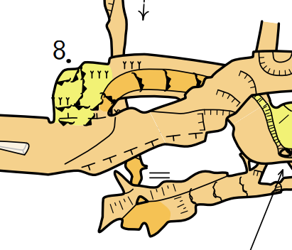

Hi David, and welcome to the mailing list!
thfill p withcolor (0.96, 0.82, 0.55);
Since Therion 6.0: thfill p withcolor (0.96, 0.82, 0.55) withalpha 0.5; In earlier versions you need to use withtransparentcolor instead.
Any ideas to maintain local connexion dotted line where they were at the beginning?
When you have an offset within an offset, the connection arrow gets drawn in the inner-most offset (I hope that makes sense). I wrote an article about how to work with this here, and I think this covers your use-case, but let me know if I have misunderstood your specific issue: https://therion.speleo.sk/wiki/mapconnectors Hope this helps. Tarquin

2. Connexions lines for offseted scraps:
My project covers a 4 kms cave that I have splitted into 4 sub-projects (called networks), I work in each network and gather them to get final export, usually I use connexion point in the scrap.
- Network 1 is above Network 2, therefore in the final presentation I offset Network 2
- Network 2 includes itself offseted areas which appear well when I work on export of Network 2 only.
When I compile the global project all connexion's doted lines inside network 2 appears then linked to the shadow of the network 2 offseted from the Network 1 instead of staying linked to the Network 2 >representation, result is awful with dotted lines crossing everywhere and ending in the shadow area.
Any ideas to maintain local connexion dotted line where they were at the beginning?
Thanks in advance
David
David, Tarquin I think David is experiencing the problem that sent me in the direction of ICCaving Migovec project point connection symbols. I think Tarquin’s explanation and approach, https://therion.speleo.sk/wiki/mapconnectors, like the Therion Book example only goes two levels deep, ie offset of offset. I have attempted to go three levels, offset of offset of offset, and the map-connections that worked for two level suddenly flip to originate from the main map. Below I show the image that I provided in my last email, and for comparison the same image with point (line) map-connection shown. It is a vertical shaft system with sufficient horizontal development at some levels to warrant plan views as well as elevation views. If I stick to two levels of offset, the map-connectors are recti-linear going from map to submap to submap (rectilinear). If I go to three or more levels they flip to going from the map selected for export to the respective submaps (radial), as is shown in the above image. I tried to explain the problem and some of the experimentation I have tried here https://github.com/therion/therion/issues/412 My explanation is tedious and hard to follow I am afraid. Still unsure if I am doing something wrong, or if there is some work around I can use. I could keep to two levels offset, but doing that results in a map that is hard to follow. For now the IC Caving Migovec approach seems best, but I would prefer to be able to make judicious use of both at the same time. Bruce
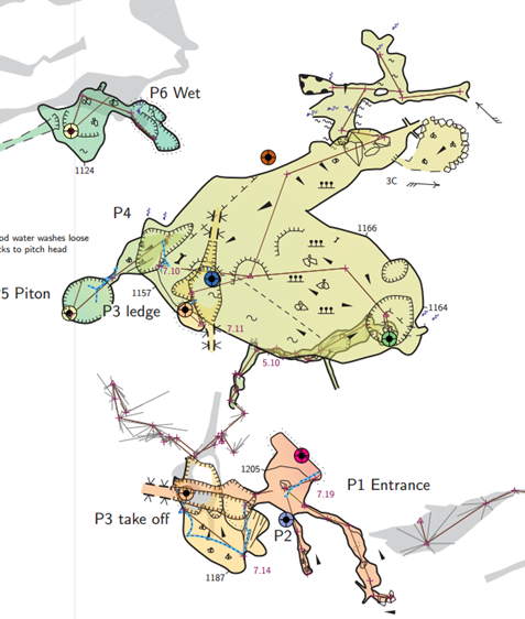
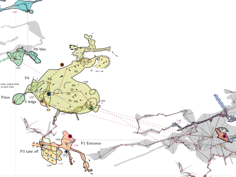
I think Tarquin’s explanation and approach, https://therion.speleo.sk/wiki/mapconnectors, like the Therion Book example only goes two levels deep, ie offset of offset.
I have attempted to go three levels, offset of offset of offset, and the map-connections that worked for two level suddenly flip to originate from the main map.
There isn't an emoticon horrified enough to cope with how that made me feel! It was already complicated enough at 2 levels. In my current map, I do everything in just 2 levels though, because it made things cleaner for me. Outer map specifies the offset for each inner map, giving the location their arrow must start from (ie. what is the offset of the piece of cave the arrow starts from). Inside that is the offset of that piece of cave compared with the offset of the previous piece, which creates the arrow. Therefore there is only ever 2 levels of offset. It does mean that if you change 1 map's offset by 1 metre, you must also update the offset for every map down the chain. But it was still easier than infinitely nesting maps (17 offset levels deep!). But I just tested it done with multiple levels, and my offset arrows still work, so I cannot reproduce the behaviour you described. It is always the inner-most offset (so to speak) that creates the arrow. At least with my stuff - you doubtless have much more complex stuff than me.
But I just tested it done with multiple levels, and my offset arrows still work, so I cannot reproduce the behaviour you described. It is always the inner-most offset (so to speak) that creates the arrow. At least with my stuff - you doubtless have much more complex stuff than me.
...mumbles "must be something I'm doing", and "I was trying to keep my data structure simple". Obviously I failed on the simple bit. Clutching at straws - I wonder if it because I define lowest level maps outside of the survey they are associated with? map 5-HawkesPlan -projection plan 5-HawkesPlan-s1 5-HawkesPlan-s2 endmap map 5-HawkesPlanCL -projection plan 5 # a map containing only the survey centreline endmap survey 5 -title "5-Hawkes" centreline #survey data here endcentreline endsurvey 5 A crude attempt at trying to bisect to a possible cause: * I'm guessing Tarquin defines his maps INSIDE lowest level surveys (survey 5 in the above example), rather than outside as I have done above. * David, I wonder which approach you use? Low level maps defined inside or outside of the low level survey? Regardless of the outcome of this quiz it won’t necessarily point to a correct reason, because there are other characteristics of project setup that could affect the answers (relationship of these low level surveys and maps to the surveys and maps that collect together the whole cave). Bruce
Clutching at straws - I wonder if it because I define lowest level maps outside of the survey they are associated with?
Well, that is definitely different from me. Every survey contains its own maps of its scraps. survey foo -title "day 1 at the swamp" map fooMP -projection plan area1SP area2SP endmap centreline ...data... endcentreline endsurvey Each parent survey contains maps with any potential offsets: survey thecave input foo/foo.th ... #these say how long the arrows should be # XP = exploded plan, in case you were wondering map fooXP -projection plan fooMP@foo [4 -47 m] none endmap ... #these say where the arrows should point to - ie. the total offset #of the "parent" piece of cave it connects to map thecaveXP -projection plan fooXP [123 15m] none endmap endsurvey The grandparent survey contains the whole area, minor caves, surface, etc. and for testing purposes, I added another offset at this level, and everything worked: survey thevalley input thecave/thecave.th ... map valleyXP -projection plan thecaveXP@thecave [-20 123 m] none othercaveXP@othercave endmap endsurvey This is the basic structure that I try to maintain. I do not generally have sub-sub-sub-surveys since none of my projects so far are big enough to want to divide a cave into areas within areas. So I do not have any data to test deeper. (Inception might come into play.) Who knows why Therion likes my setup more? Tarquin
Thanks Bruce and Tarkin for your advices. Connexion lines & offsetThe structure of my program doesn't look like Tarkin's last description. Issue is similar to Bruce's one description.I managed to improve the issue in several cases with removing a maximum of mid level map to come back to 2 level max, ok for most but still ko when I need a third level of offset for serial pit for example :( Ok for "withtransparentcolor" I have recovered transparency :) tks Tarkin Have a good weekDavid Le dimanche 10 juillet 2022 à 02:41:02 UTC+2, Bruce Mutton <bruce@tomo.co.nz> a écrit :
But I just tested it done with multiple levels, and my offset arrows still work, so I cannot reproduce the behaviour you described. It is always the inner-most offset (so to speak) that creates the arrow. At least with my stuff - you doubtless have much more complex stuff than me.
...mumbles "must be something I'm doing", and "I was trying to keep my data structure simple". Obviously I failed on the simple bit. Clutching at straws - I wonder if it because I define lowest level maps outside of the survey they are associated with? map 5-HawkesPlan -projection plan 5-HawkesPlan-s1 5-HawkesPlan-s2 endmap map 5-HawkesPlanCL -projection plan 5 # a map containing only the survey centreline endmap survey 5 -title "5-Hawkes" centreline #survey data here endcentreline endsurvey 5 A crude attempt at trying to bisect to a possible cause: - I'm guessing Tarquin defines his maps INSIDE lowest level surveys (survey 5 in the above example), rather than outside as I have done above. - David, I wonder which approach you use? Low level maps defined inside or outside of the low level survey? Regardless of the outcome of this quiz it won’t necessarily point to a correct reason, because there are other characteristics of project setup that could affect the answers (relationship of these low level surveys and maps to the surveys and maps that collect together the whole cave). Bruce _______________________________________________ Therion mailing list Therion@speleo.sk https://mailman.speleo.sk/listinfo/therion
Dear All 1- scale & Export: Little issue, I think already answerred but can not find it back! My survey is quite huge and I need to export different scalesIn the biggest I would like to remove all little object and particularly text from the export to make it more understandable. I use all scale of text xs,s,m,l,xl 3,5 .....With the option HIDEN or SHOW I only manage to remove all or nothing.Any way to remove only text which scale is < to l ? 2- Offseted map: this topic is known but I would like to know if there were some progress? Some under-level of offsetted map refers directly to the initial shadow when using connection map point. MAPMAP-1 okMAP-2 ok if based on scrapMAP-2 ko if refering to a mapMAP-3 ok Thanks in advance for your help David
Hi David,
My survey is quite huge and I need to export different scales In the biggest I would like to remove all little object and particularly text from the export to make it more understandable.
Yes, but also no: https://therion.speleo.sk/wiki/templates#setup_a_default_standard_layout layoutstandards.txt has some metapost code that can hide small text labels. *BUT* the way it works is to physically measure the size of the text label. So if - for example - you have something like this: point 740.0 918.5 label -scale xl -text [foo<br>bar] -align left The linebreak in there makes the rendered text block taller than one line of text would be. The metapost code does not understand that, so it assumes it must be a large text size, and it allows it to render. (Yes, it would be possible to make the code check only the first text character, but that is not as easy as you might think, since the first character can be a linebreak, or formatting.) You can also use this layout option: min-symbol-scale M but that affects all symbols at once, and you need to remember that all lines have a default size, even if you did not explicitly set one! Therion really, really needs to have a setting like this: min-symbol-scale point label M * wishes *
*2- Offseted map:*
this topic is known but I would like to know if there were some progress?
Some under-level of offsetted map refers directly to the initial shadow when using connection map point.
Sorry, I do not understand this question, could you perhaps explain in more detail? Cheers, Tarquin
Dear Tarquin Thanks a lot for your answersmin-symbol-scale m => works well eventhough as you mentionned wall disapearred ! fortunatly I have colored surfaces everywhere and except cross-over section that I will re-scale manually the rest is really correct! I try to be more clear on my second topic, the problem is that the connection arrow between offsetted map sometimes skipped the N+1 map to be connected directly to the N+2 map: Exemple:1 - (level N+2) Global map: MAP 1 2- (level N+1) offsetted network below from MAP1= MAP2 => map connection point arrow of MAP2 goes from its shadow on MAP1 to MAP2 => ok 3- (level N) offsetted network below from MAP2= MAP3 2 cases: 3.1 MAP3 is built by scrap S1 S2 etc.... => ok map connection point arrow goes from MAP3 to its shadow on MAP2 and then idem from MAP2 to MAP1 => clean 3.2 MAP3 is built by other MAP (level N-1) => Ko map connection point arrow goes directly to shadows on MAP1 skipping its shadow on MAP2 I hope it is more clear, if not I'll send you tonight a better description with picture. the problem is that in case there are several map to offset the rendering at the end is unclear except if you keep all your rmap at the level 1 (ex level of MAP2) but in that case you can not follow easely the real path in your cave. Not sure it is better :)David . Le lundi 13 mars 2023 à 11:56:31 UTC+1, Tarquin Wilton-Jones via Therion <therion@speleo.sk> a écrit : Hi David,
My survey is quite huge and I need to export different scales In the biggest I would like to remove all little object and particularly text from the export to make it more understandable.
Yes, but also no: https://therion.speleo.sk/wiki/templates#setup_a_default_standard_layout layoutstandards.txt has some metapost code that can hide small text labels. *BUT* the way it works is to physically measure the size of the text label. So if - for example - you have something like this: point 740.0 918.5 label -scale xl -text [foo<br>bar] -align left The linebreak in there makes the rendered text block taller than one line of text would be. The metapost code does not understand that, so it assumes it must be a large text size, and it allows it to render. (Yes, it would be possible to make the code check only the first text character, but that is not as easy as you might think, since the first character can be a linebreak, or formatting.) You can also use this layout option: min-symbol-scale M but that affects all symbols at once, and you need to remember that all lines have a default size, even if you did not explicitly set one! Therion really, really needs to have a setting like this: min-symbol-scale point label M * wishes *
*2- Offseted map:*
this topic is known but I would like to know if there were some progress?
Some under-level of offsetted map refers directly to the initial shadow when using connection map point.
Sorry, I do not understand this question, could you perhaps explain in more detail? Cheers, Tarquin _______________________________________________ Therion mailing list Therion@speleo.sk https://mailman.speleo.sk/listinfo/therion
David, Tarquin I think we discussed the map-connection offsets last year, without real resolution. I couldn’t find them in the mail-archive just now, so I’ll send my posts again in the hope that they describe the problem and present results of some experimentation that defines somewhat the parameters of the problem. Stand by. Bruce From: Therion <therion-bounces@speleo.sk> On Behalf Of david Le berre via Therion Sent: Tuesday, 14 March 2023 03:12 To: therion@speleo.sk Cc: david Le berre <davleb@yahoo.fr> Subject: Re: [Therion] Remove little text in global export & offseted map Dear Tarquin Thanks a lot for your answers min-symbol-scale m => works well eventhough as you mentionned wall disapearred ! fortunatly I have colored surfaces everywhere and except cross-over section that I will re-scale manually the rest is really correct! I try to be more clear on my second topic, the problem is that the connection arrow between offsetted map sometimes skipped the N+1 map to be connected directly to the N+2 map: Exemple: 1 - (level N+2) Global map: MAP 1 2- (level N+1) offsetted network below from MAP1= MAP2 => map connection point arrow of MAP2 goes from its shadow on MAP1 to MAP2 => ok 3- (level N) offsetted network below from MAP2= MAP3 2 cases: 3.1 MAP3 is built by scrap S1 S2 etc.... => ok map connection point arrow goes from MAP3 to its shadow on MAP2 and then idem from MAP2 to MAP1 => clean 3.2 MAP3 is built by other MAP (level N-1) => Ko map connection point arrow goes directly to shadows on MAP1 skipping its shadow on MAP2 I hope it is more clear, if not I'll send you tonight a better description with picture. the problem is that in case there are several map to offset the rendering at the end is unclear except if you keep all your rmap at the level 1 (ex level of MAP2) but in that case you can not follow easely the real path in your cave. Not sure it is better :) David . Le lundi 13 mars 2023 à 11:56:31 UTC+1, Tarquin Wilton-Jones via Therion <therion@speleo.sk <mailto:therion@speleo.sk> > a écrit : Hi David,
My survey is quite huge and I need to export different scales
In the biggest I would like to remove all little object and particularly
text from the export to make it more understandable.
Yes, but also no: https://therion.speleo.sk/wiki/templates#setup_a_default_standard_layout layoutstandards.txt has some metapost code that can hide small text labels. *BUT* the way it works is to physically measure the size of the text label. So if - for example - you have something like this: point 740.0 918.5 label -scale xl -text [foo<br>bar] -align left The linebreak in there makes the rendered text block taller than one line of text would be. The metapost code does not understand that, so it assumes it must be a large text size, and it allows it to render. (Yes, it would be possible to make the code check only the first text character, but that is not as easy as you might think, since the first character can be a linebreak, or formatting.) You can also use this layout option: min-symbol-scale M but that affects all symbols at once, and you need to remember that all lines have a default size, even if you did not explicitly set one! Therion really, really needs to have a setting like this: min-symbol-scale point label M * wishes *
*2- Offseted map:*
this topic is known but I would like to know if there were some progress?
Some under-level of offsetted map refers directly to the initial shadow
when using connection map point.
Sorry, I do not understand this question, could you perhaps explain in more detail? Cheers, Tarquin _______________________________________________ Therion mailing list Therion@speleo.sk <mailto:Therion@speleo.sk> https://mailman.speleo.sk/listinfo/therion

Just a sample. Colorised by altitude. M.
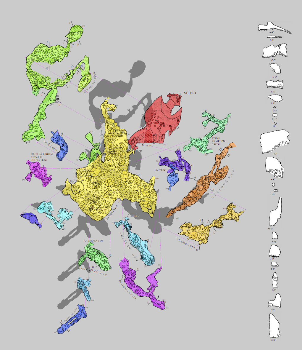
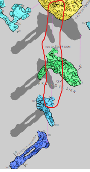
Interesting Martin Your example mostly demonstrates one level of offset, but it goes to two levels bottom-left (to blue to purple), and apparently three levels at the bottom (to green to blue to dark blue). However looking closely it seems that the map-connection line to blue goes directly from yellow (ie not from green). If this is the case there are two scenarios: Scenario 1 - based on the map-connection line I have highlighted, both the green and blue are first-level offsets. I may be mistaken as the image is not sufficiently clear. If it is two levels of offset, then that is not sufficient to trigger the 'bug' David and I have described. If it is three levels of offset, then you have somehow managed to avoid the 'bug' and the map-connection lines/points are coincidentally on the same alignment. Scenario 2 - is that this example demonstrates the 'bug' described, if not particularly clearly. My synopsis of the bug was "the line created by point map-connection is only correctly originating from its parent map at the most deeply nested level of offset and at the 1st level offset. At all other (intermediate) offset levels, the map-connection line reverts to originating from the top-level map, and not from its direct parent." So Martin, if you could perhaps clarify. I suggest adding a horizontal component to the light blue map in my snip above, and confirming whether the map offsets are two or three level. If it is two level, it does not test the bug. If it is three level and there is no 'bug', the map connection line, blue to dark blue, should radiate from blue and not from yellow. Tarquin I'll respond to your message later - off to work now! Thanks Bruce From: Therion <therion-bounces@speleo.sk> On Behalf Of Martin Sluka via Therion Sent: Wednesday, 15 March 2023 23:08 To: List for Therion users <therion@speleo.sk> Cc: Martin Sluka <martinsluka@mac.com> Subject: Re: [Therion] 2 Map-connection issue - Going to four levels - Offset tests SAMD-ITF-IS example Just a sample. Colorised by altitude. M.
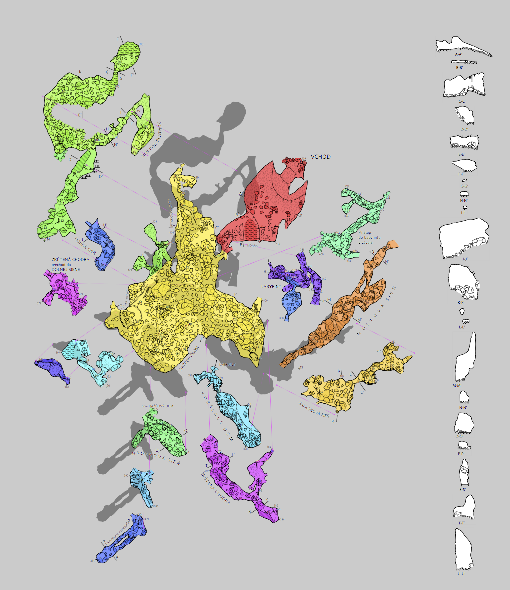
Definition of that map: map modrovska_plan.map -title "Modrovská jaskyňa" modrovska_s01.map modrovska_s03.map break modrovska_s30.map modrovska_s12-21.map [-18 10 m] below break modrovska_s27.map #Mostová sieň break modrovska_s26.map [10 -5 m] below modrovska_s16.map [25 10 m] below break modrovska_s11-20.map [-7 -5 m] below break modrovska_s19-24-25.map [0 -10 m] below modrovska_s13.map [-10 5 m] below modrovska_s28.map [-2 -9 m] below break modrovska_s14.map [14 -3 m] below break modrovska_s15.map [1 -22 m] below modrovska_s22.map [-20 0 m] below endmap
15. 3. 2023 v 19:56, Bruce Mutton <bruce@tomo.co.nz>:
Interesting Martin Your example mostly demonstrates one level of offset, but it goes to two levels bottom-left (to blue to purple), and apparently three levels at the bottom (to green to blue to dark blue). However looking closely it seems that the map-connection line to blue goes directly from yellow (ie not from green). If this is the case there are two scenarios: <image002.png> Scenario 1 - based on the map-connection line I have highlighted, both the green and blue are first-level offsets. I may be mistaken as the image is not sufficiently clear. If it is two levels of offset, then that is not sufficient to trigger the ‘bug’ David and I have described. If it is three levels of offset, then you have somehow managed to avoid the ‘bug’ and the map-connection lines/points are coincidentally on the same alignment.
Scenario 2 – is that this example demonstrates the ‘bug’ described, if not particularly clearly. My synopsis of the bug was “the line created by point map-connection is only correctly originating from its parent map at the most deeply nested level of offset and at the 1st level offset. At all other (intermediate) offset levels, the map-connection line reverts to originating from the top-level map, and not from its direct parent.”
So Martin, if you could perhaps clarify. I suggest adding a horizontal component to the light blue map in my snip above, and confirming whether the map offsets are two or three level. If it is two level, it does not test the bug. If it is three level and there is no ‘bug’, the map connection line, blue to dark blue, should radiate from blue and not from yellow.
Tarquin I’ll respond to your message later – off to work now!
Thanks Bruce
From: Therion <therion-bounces@speleo.sk <mailto:therion-bounces@speleo.sk>> On Behalf Of Martin Sluka via Therion Sent: Wednesday, 15 March 2023 23:08 To: List for Therion users <therion@speleo.sk <mailto:therion@speleo.sk>> Cc: Martin Sluka <martinsluka@mac.com <mailto:martinsluka@mac.com>> Subject: Re: [Therion] 2 Map-connection issue - Going to four levels - Offset tests SAMD-ITF-IS example
Just a sample. Colorised by altitude.
M.
<image001.png> _______________________________________________ Therion mailing list Therion@speleo.sk <mailto:Therion@speleo.sk> https://mailman.speleo.sk/listinfo/therion <https://mailman.speleo.sk/listinfo/therion>
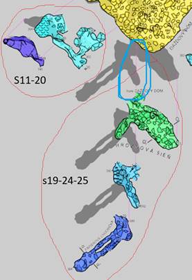
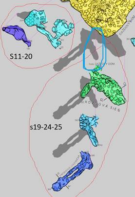
Thanks Martin The definition shows just first level offsets. Taken together with the submap naming and the image of the map itself, I deduce that: - map s11-20 contains a second level offset. - map s19-24-25 contains a second and third level offset. This is the one that I am unsure as to whether or not it displays the bug I have proposed. Hopefully I have identified them correctly in the image below. - none of the other maps include an offset. modrovska_s12-21.map seems to include two maps, but they have not been offset from each other. 1. Can you supply the map definitions for modrovska_s19-24-25.map, and any submaps it might contain, down to scrap level? 2. Can you change the offsets for the submaps below modrovska_s19-24-25.map so they do not line up with each other? I am suspicious that the map-connection line that I have highlighted in light blue shows that the bug I describe is present in your example. ie The intermediate offset level (light blue map) map-connection line reverts to originating from the top-level map, and not from its direct parent. But I cannot be sure without the above two bits of information. Also, another variable. I presume from our correspondence over the years that it is likely that this dataset maintains complete separation of maps from surveys. ie There are no survey objects that have map objects defined within them. That will be interesting regardless of whether this dataset manifests this ‘bug’ or not. Thanks for your effort. Bruce From: Therion <therion-bounces@speleo.sk> On Behalf Of Martin Sluka via Therion Sent: Thursday, 16 March 2023 22:33 To: List for Therion users <therion@speleo.sk> Cc: Martin Sluka <martinsluka@mac.com> Subject: Re: [Therion] 2 Map-connection issue - Going to four levels - Offset tests SAMD-ITF-IS example Definition of that map: map modrovska_plan.map -title "Modrovská jaskyňa" modrovska_s01.map modrovska_s03.map break modrovska_s30.map modrovska_s12-21.map [-18 10 m] below break modrovska_s27.map #Mostová sieň break modrovska_s26.map [10 -5 m] below modrovska_s16.map [25 10 m] below break modrovska_s11-20.map [-7 -5 m] below break modrovska_s19-24-25.map [0 -10 m] below modrovska_s13.map [-10 5 m] below modrovska_s28.map [-2 -9 m] below break modrovska_s14.map [14 -3 m] below break modrovska_s15.map [1 -22 m] below modrovska_s22.map [-20 0 m] below endmap 15. 3. 2023 v 19:56, Bruce Mutton <bruce@tomo.co.nz <mailto:bruce@tomo.co.nz> >: Interesting Martin Your example mostly demonstrates one level of offset, but it goes to two levels bottom-left (to blue to purple), and apparently three levels at the bottom (to green to blue to dark blue). However looking closely it seems that the map-connection line to blue goes directly from yellow (ie not from green). If this is the case there are two scenarios: <image002.png> Scenario 1 - based on the map-connection line I have highlighted, both the green and blue are first-level offsets. I may be mistaken as the image is not sufficiently clear. If it is two levels of offset, then that is not sufficient to trigger the ‘bug’ David and I have described. If it is three levels of offset, then you have somehow managed to avoid the ‘bug’ and the map-connection lines/points are coincidentally on the same alignment. Scenario 2 – is that this example demonstrates the ‘bug’ described, if not particularly clearly. My synopsis of the bug was “the line created by point map-connection is only correctly originating from its parent map at the most deeply nested level of offset and at the 1st level offset. At all other (intermediate) offset levels, the map-connection line reverts to originating from the top-level map, and not from its direct parent.” So Martin, if you could perhaps clarify. I suggest adding a horizontal component to the light blue map in my snip above, and confirming whether the map offsets are two or three level. If it is two level, it does not test the bug. If it is three level and there is no ‘bug’, the map connection line, blue to dark blue, should radiate from blue and not from yellow. Tarquin I’ll respond to your message later – off to work now! Thanks Bruce From: Therion <therion-bounces@speleo.sk <mailto:therion-bounces@speleo.sk> > On Behalf Of Martin Sluka via Therion Sent: Wednesday, 15 March 2023 23:08 To: List for Therion users <therion@speleo.sk <mailto:therion@speleo.sk> > Cc: Martin Sluka <martinsluka@mac.com <mailto:martinsluka@mac.com> > Subject: Re: [Therion] 2 Map-connection issue - Going to four levels - Offset tests SAMD-ITF-IS example Just a sample. Colorised by altitude. M. <image001.png> _______________________________________________ Therion mailing list <mailto:Therion@speleo.sk> Therion@speleo.sk <https://mailman.speleo.sk/listinfo/therion> https://mailman.speleo.sk/listinfo/therion
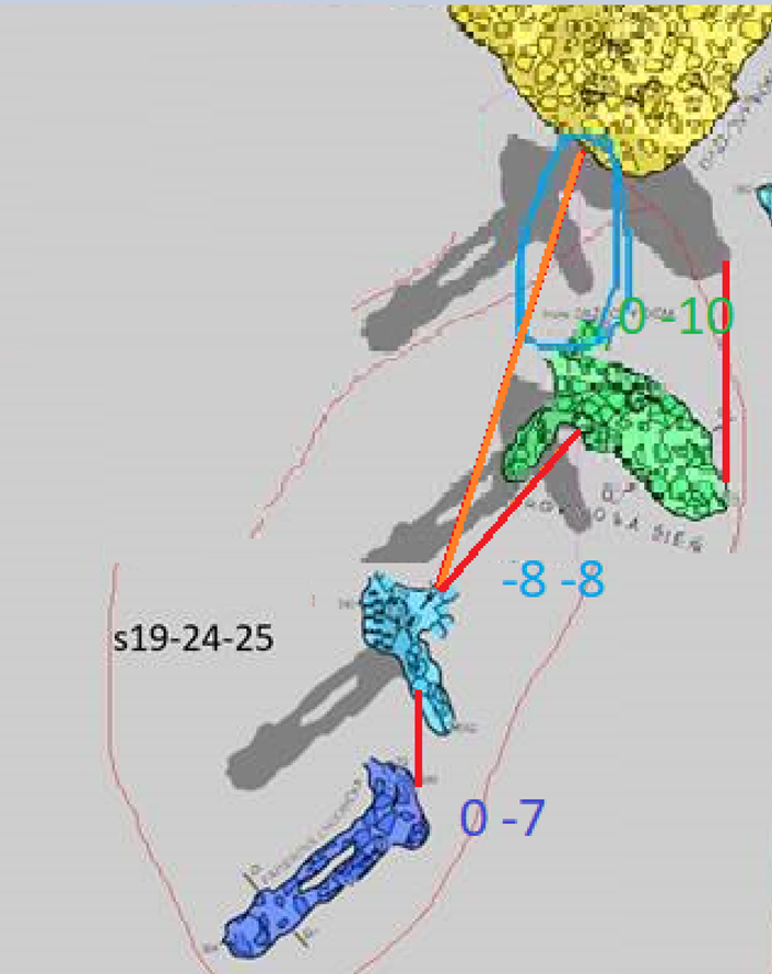
Thanks for the map definitions Martin Highlighting the relevant parts of the definitions, I think they define three levels of offsets, green, blue, dark blue respectively… Top level map with first level offset map modrovska_plan.map -title "Modrovská jaskyňa" … modrovska_s19-24-25.map [0 -10 m] below … endmap Next level map with second level offset (offset of offset) map modrovska_s19-24-25.map … modrovska_s24-25.map [0 -8 m] below endmap Next level map with third level offset (offset of offset of offset) map modrovska_s24-25.map … modrovska_s24.map [0 -7 m] below endmap To test the map-connection lines for the intermediate (second level) offset, could you compile the project with an offset of -8 -8 m, like this? map modrovska_s19-24-25.map … modrovska_s24-25.map [-8 -8 m] below endmap The resulting output should look something like this rough markup. The red map-connection lines are correct lines I believe. If there is a map connection line like the orange line, then I believe the bug affects this dataset in the same way it affects my datasets. Bruce From: Therion <therion-bounces@speleo.sk> On Behalf Of Martin Sluka via Therion Sent: Thursday, 23 March 2023 20:32 To: List for Therion users <therion@speleo.sk> Cc: Martin Sluka <martinsluka@mac.com> Subject: Re: [Therion] 2 Map-connection issue - Going to four levels - Offset tests SAMD-ITF-IS example Hi, I used the offset only to generate final map. Definitions of particular maps is very simple: <snipped> From: Therion <therion-bounces@speleo.sk> On Behalf Of Bruce Mutton Sent: Sunday, 19 March 2023 12:53 To: 'List for Therion users' <therion@speleo.sk> Subject: [Therion] 2 Map-connection issue - Going to four levels - Offset tests SAMD-ITF-IS example Thanks Martin The definition shows just first level offsets. Taken together with the submap naming and the image of the map itself, I deduce that: - map s11-20 contains a second level offset. - map s19-24-25 contains a second and third level offset. This is the one that I am unsure as to whether or not it displays the bug I have proposed. Hopefully I have identified them correctly in the image below. - none of the other maps include an offset. modrovska_s12-21.map seems to include two maps, but they have not been offset from each other. 1. Can you supply the map definitions for modrovska_s19-24-25.map, and any submaps it might contain, down to scrap level? 2. Can you change the offsets for the submaps below modrovska_s19-24-25.map so they do not line up with each other? I am suspicious that the map-connection line that I have highlighted in light blue shows that the bug I describe is present in your example. ie The intermediate offset level (light blue map) map-connection line reverts to originating from the top-level map, and not from its direct parent. But I cannot be sure without the above two bits of information. Also, another variable. I presume from our correspondence over the years that it is likely that this dataset maintains complete separation of maps from surveys. ie There are no survey objects that have map objects defined within them. That will be interesting regardless of whether this dataset manifests this ‘bug’ or not. Thanks for your effort. Bruce From: Therion <therion-bounces@speleo.sk <mailto:therion-bounces@speleo.sk> > On Behalf Of Martin Sluka via Therion Sent: Thursday, 16 March 2023 22:33 To: List for Therion users <therion@speleo.sk <mailto:therion@speleo.sk> > Cc: Martin Sluka <martinsluka@mac.com <mailto:martinsluka@mac.com> > Subject: Re: [Therion] 2 Map-connection issue - Going to four levels - Offset tests SAMD-ITF-IS example Definition of that map: map modrovska_plan.map -title "Modrovská jaskyňa" modrovska_s01.map modrovska_s03.map break modrovska_s30.map modrovska_s12-21.map [-18 10 m] below break modrovska_s27.map #Mostová sieň break modrovska_s26.map [10 -5 m] below modrovska_s16.map [25 10 m] below break modrovska_s11-20.map [-7 -5 m] below break modrovska_s19-24-25.map [0 -10 m] below modrovska_s13.map [-10 5 m] below modrovska_s28.map [-2 -9 m] below break modrovska_s14.map [14 -3 m] below break modrovska_s15.map [1 -22 m] below modrovska_s22.map [-20 0 m] below endmap 15. 3. 2023 v 19:56, Bruce Mutton <bruce@tomo.co.nz <mailto:bruce@tomo.co.nz> >: Interesting Martin Your example mostly demonstrates one level of offset, but it goes to two levels bottom-left (to blue to purple), and apparently three levels at the bottom (to green to blue to dark blue). However looking closely it seems that the map-connection line to blue goes directly from yellow (ie not from green). If this is the case there are two scenarios: <image002.png> Scenario 1 - based on the map-connection line I have highlighted, both the green and blue are first-level offsets. I may be mistaken as the image is not sufficiently clear. If it is two levels of offset, then that is not sufficient to trigger the ‘bug’ David and I have described. If it is three levels of offset, then you have somehow managed to avoid the ‘bug’ and the map-connection lines/points are coincidentally on the same alignment. Scenario 2 – is that this example demonstrates the ‘bug’ described, if not particularly clearly. My synopsis of the bug was “the line created by point map-connection is only correctly originating from its parent map at the most deeply nested level of offset and at the 1st level offset. At all other (intermediate) offset levels, the map-connection line reverts to originating from the top-level map, and not from its direct parent.” So Martin, if you could perhaps clarify. I suggest adding a horizontal component to the light blue map in my snip above, and confirming whether the map offsets are two or three level. If it is two level, it does not test the bug. If it is three level and there is no ‘bug’, the map connection line, blue to dark blue, should radiate from blue and not from yellow. Tarquin I’ll respond to your message later – off to work now! Thanks Bruce From: Therion <therion-bounces@speleo.sk <mailto:therion-bounces@speleo.sk> > On Behalf Of Martin Sluka via Therion Sent: Wednesday, 15 March 2023 23:08 To: List for Therion users <therion@speleo.sk <mailto:therion@speleo.sk> > Cc: Martin Sluka <martinsluka@mac.com <mailto:martinsluka@mac.com> > Subject: Re: [Therion] 2 Map-connection issue - Going to four levels - Offset tests SAMD-ITF-IS example Just a sample. Colorised by altitude. M. <image001.png> _______________________________________________ Therion mailing list <mailto:Therion@speleo.sk> Therion@speleo.sk <https://mailman.speleo.sk/listinfo/therion> https://mailman.speleo.sk/listinfo/therion
23. 3. 2023 v 9:24, Bruce Mutton <bruce@tomo.co.nz>:
Thanks for the map definitions Martin Highlighting the relevant parts of the definitions, I think they define three levels of offsets, green, blue, dark blue respectively…
Top level map with first level offset map modrovska_plan.map -title "Modrovská jaskyňa" … modrovska_s19-24-25.map [0 -10 m] below … endmap Next level map with second level offset (offset of offset) map modrovska_s19-24-25.map … modrovska_s24-25.map [0 -8 m] below endmap Next level map with third level offset (offset of offset of offset) map modrovska_s24-25.map … modrovska_s24.map [0 -7 m] below endmap
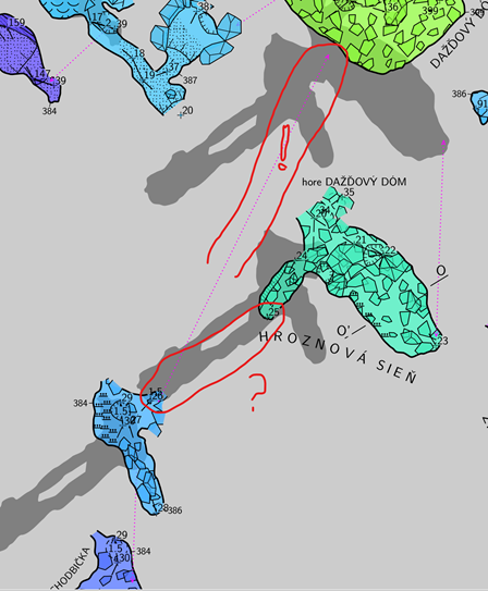
To test the map-connection lines for the intermediate (second level) offset, could you compile the project with an offset of -8 -8 m, like this? map modrovska_s19-24-25.map … modrovska_s24-25.map [-8 -8 m] below endmap
The resulting output should look something like this rough markup. <image002.png>
The red map-connection lines are correct lines I believe. If there is a map connection line like the orange line, then I believe the bug affects this dataset in the same way it affects my datasets.
Bruce
From: Therion <therion-bounces@speleo.sk <mailto:therion-bounces@speleo.sk>> On Behalf Of Martin Sluka via Therion Sent: Thursday, 23 March 2023 20:32 To: List for Therion users <therion@speleo.sk <mailto:therion@speleo.sk>> Cc: Martin Sluka <martinsluka@mac.com <mailto:martinsluka@mac.com>> Subject: Re: [Therion] 2 Map-connection issue - Going to four levels - Offset tests SAMD-ITF-IS example
Hi,
I used the offset only to generate final map.
Definitions of particular maps is very simple: <snipped>
From: Therion <therion-bounces@speleo.sk <mailto:therion-bounces@speleo.sk>> On Behalf Of Bruce Mutton Sent: Sunday, 19 March 2023 12:53 To: 'List for Therion users' <therion@speleo.sk <mailto:therion@speleo.sk>> Subject: [Therion] 2 Map-connection issue - Going to four levels - Offset tests SAMD-ITF-IS example
Thanks Martin The definition shows just first level offsets. Taken together with the submap naming and the image of the map itself, I deduce that: - map s11-20 contains a second level offset. - map s19-24-25 contains a second and third level offset. This is the one that I am unsure as to whether or not it displays the bug I have proposed. Hopefully I have identified them correctly in the image below. - none of the other maps include an offset. modrovska_s12-21.map seems to include two maps, but they have not been offset from each other.
<image006.jpg>
Can you supply the map definitions for modrovska_s19-24-25.map, and any submaps it might contain, down to scrap level? Can you change the offsets for the submaps below modrovska_s19-24-25.map so they do not line up with each other? I am suspicious that the map-connection line that I have highlighted in light blue shows that the bug I describe is present in your example. ie The intermediate offset level (light blue map) map-connection line reverts to originating from the top-level map, and not from its direct parent. But I cannot be sure without the above two bits of information.
Also, another variable. I presume from our correspondence over the years that it is likely that this dataset maintains complete separation of maps from surveys. ie There are no survey objects that have map objects defined within them. That will be interesting regardless of whether this dataset manifests this ‘bug’ or not.
Thanks for your effort. Bruce
From: Therion <therion-bounces@speleo.sk <mailto:therion-bounces@speleo.sk>> On Behalf Of Martin Sluka via Therion Sent: Thursday, 16 March 2023 22:33 To: List for Therion users <therion@speleo.sk <mailto:therion@speleo.sk>> Cc: Martin Sluka <martinsluka@mac.com <mailto:martinsluka@mac.com>> Subject: Re: [Therion] 2 Map-connection issue - Going to four levels - Offset tests SAMD-ITF-IS example
Definition of that map:
map modrovska_plan.map -title "Modrovská jaskyňa" modrovska_s01.map modrovska_s03.map break modrovska_s30.map
modrovska_s12-21.map [-18 10 m] below break modrovska_s27.map #Mostová sieň break modrovska_s26.map [10 -5 m] below modrovska_s16.map [25 10 m] below break modrovska_s11-20.map [-7 -5 m] below break modrovska_s19-24-25.map [0 -10 m] below modrovska_s13.map [-10 5 m] below modrovska_s28.map [-2 -9 m] below break modrovska_s14.map [14 -3 m] below break modrovska_s15.map [1 -22 m] below modrovska_s22.map [-20 0 m] below endmap
15. 3. 2023 v 19:56, Bruce Mutton <bruce@tomo.co.nz <mailto:bruce@tomo.co.nz>>:
Interesting Martin Your example mostly demonstrates one level of offset, but it goes to two levels bottom-left (to blue to purple), and apparently three levels at the bottom (to green to blue to dark blue). However looking closely it seems that the map-connection line to blue goes directly from yellow (ie not from green). If this is the case there are two scenarios: <image002.png> Scenario 1 - based on the map-connection line I have highlighted, both the green and blue are first-level offsets. I may be mistaken as the image is not sufficiently clear. If it is two levels of offset, then that is not sufficient to trigger the ‘bug’ David and I have described. If it is three levels of offset, then you have somehow managed to avoid the ‘bug’ and the map-connection lines/points are coincidentally on the same alignment.
Scenario 2 – is that this example demonstrates the ‘bug’ described, if not particularly clearly. My synopsis of the bug was “the line created by point map-connection is only correctly originating from its parent map at the most deeply nested level of offset and at the 1st level offset. At all other (intermediate) offset levels, the map-connection line reverts to originating from the top-level map, and not from its direct parent.”
So Martin, if you could perhaps clarify. I suggest adding a horizontal component to the light blue map in my snip above, and confirming whether the map offsets are two or three level. If it is two level, it does not test the bug. If it is three level and there is no ‘bug’, the map connection line, blue to dark blue, should radiate from blue and not from yellow.
Tarquin I’ll respond to your message later – off to work now!
Thanks Bruce
From: Therion <therion-bounces@speleo.sk <mailto:therion-bounces@speleo.sk>> On Behalf Of Martin Sluka via Therion Sent: Wednesday, 15 March 2023 23:08 To: List for Therion users <therion@speleo.sk <mailto:therion@speleo.sk>> Cc: Martin Sluka <martinsluka@mac.com <mailto:martinsluka@mac.com>> Subject: Re: [Therion] 2 Map-connection issue - Going to four levels - Offset tests SAMD-ITF-IS example
Just a sample. Colorised by altitude.
M.
<image001.png> _______________________________________________ Therion mailing list Therion@speleo.sk <mailto:Therion@speleo.sk> https://mailman.speleo.sk/listinfo/therion <https://mailman.speleo.sk/listinfo/therion>
_______________________________________________ Therion mailing list Therion@speleo.sk <mailto:Therion@speleo.sk> https://mailman.speleo.sk/listinfo/therion <https://mailman.speleo.sk/listinfo/therion>
I’m sorry, this is correct output with [-8 -8m ]:
23. 3. 2023 v 9:24, Bruce Mutton <bruce@tomo.co.nz>:
Thanks for the map definitions Martin Highlighting the relevant parts of the definitions, I think they define three levels of offsets, green, blue, dark blue respectively…
Top level map with first level offset map modrovska_plan.map -title "Modrovská jaskyňa" … modrovska_s19-24-25.map [0 -10 m] below
endmap Next level map with second level offset (offset of offset) map modrovska_s19-24-25.map … modrovska_s24-25.map [0 -8 m] below endmap Next level map with third level offset (offset of offset of offset) map modrovska_s24-25.map … modrovska_s24.map [0 -7 m] below endmap
To test the map-connection lines for the intermediate (second level) offset, could you compile the project with an offset of -8 -8 m, like this? map modrovska_s19-24-25.map … modrovska_s24-25.map [-8 -8 m] below endmap
The resulting output should look something like this rough markup. <image002.png>
The red map-connection lines are correct lines I believe. If there is a map connection line like the orange line, then I believe the bug affects this dataset in the same way it affects my datasets.
Bruce
From: Therion <therion-bounces@speleo.sk <mailto:therion-bounces@speleo.sk>> On Behalf Of Martin Sluka via Therion Sent: Thursday, 23 March 2023 20:32 To: List for Therion users <therion@speleo.sk <mailto:therion@speleo.sk>> Cc: Martin Sluka <martinsluka@mac.com <mailto:martinsluka@mac.com>> Subject: Re: [Therion] 2 Map-connection issue - Going to four levels - Offset tests SAMD-ITF-IS example
Hi,
I used the offset only to generate final map.
Definitions of particular maps is very simple: <snipped>
From: Therion <therion-bounces@speleo.sk <mailto:therion-bounces@speleo.sk>> On Behalf Of Bruce Mutton Sent: Sunday, 19 March 2023 12:53 To: 'List for Therion users' <therion@speleo.sk <mailto:therion@speleo.sk>> Subject: [Therion] 2 Map-connection issue - Going to four levels - Offset tests SAMD-ITF-IS example
Thanks Martin The definition shows just first level offsets. Taken together with the submap naming and the image of the map itself, I deduce that: - map s11-20 contains a second level offset. - map s19-24-25 contains a second and third level offset. This is the one that I am unsure as to whether or not it displays the bug I have proposed. Hopefully I have identified them correctly in the image below. - none of the other maps include an offset. modrovska_s12-21.map seems to include two maps, but they have not been offset from each other.
<image006.jpg>
Can you supply the map definitions for modrovska_s19-24-25.map, and any submaps it might contain, down to scrap level? Can you change the offsets for the submaps below modrovska_s19-24-25.map so they do not line up with each other? I am suspicious that the map-connection line that I have highlighted in light blue shows that the bug I describe is present in your example. ie The intermediate offset level (light blue map) map-connection line reverts to originating from the top-level map, and not from its direct parent. But I cannot be sure without the above two bits of information.
Also, another variable. I presume from our correspondence over the years that it is likely that this dataset maintains complete separation of maps from surveys. ie There are no survey objects that have map objects defined within them. That will be interesting regardless of whether this dataset manifests this ‘bug’ or not.
Thanks for your effort. Bruce
From: Therion <therion-bounces@speleo.sk <mailto:therion-bounces@speleo.sk>> On Behalf Of Martin Sluka via Therion Sent: Thursday, 16 March 2023 22:33 To: List for Therion users <therion@speleo.sk <mailto:therion@speleo.sk>> Cc: Martin Sluka <martinsluka@mac.com <mailto:martinsluka@mac.com>> Subject: Re: [Therion] 2 Map-connection issue - Going to four levels - Offset tests SAMD-ITF-IS example
Definition of that map:
map modrovska_plan.map -title "Modrovská jaskyňa" modrovska_s01.map modrovska_s03.map break modrovska_s30.map
modrovska_s12-21.map [-18 10 m] below break modrovska_s27.map #Mostová sieň break modrovska_s26.map [10 -5 m] below modrovska_s16.map [25 10 m] below break modrovska_s11-20.map [-7 -5 m] below break modrovska_s19-24-25.map [0 -10 m] below modrovska_s13.map [-10 5 m] below modrovska_s28.map [-2 -9 m] below break modrovska_s14.map [14 -3 m] below break modrovska_s15.map [1 -22 m] below modrovska_s22.map [-20 0 m] below endmap
15. 3. 2023 v 19:56, Bruce Mutton <bruce@tomo.co.nz <mailto:bruce@tomo.co.nz>>:
Interesting Martin Your example mostly demonstrates one level of offset, but it goes to two levels bottom-left (to blue to purple), and apparently three levels at the bottom (to green to blue to dark blue). However looking closely it seems that the map-connection line to blue goes directly from yellow (ie not from green). If this is the case there are two scenarios: <image002.png> Scenario 1 - based on the map-connection line I have highlighted, both the green and blue are first-level offsets. I may be mistaken as the image is not sufficiently clear. If it is two levels of offset, then that is not sufficient to trigger the ‘bug’ David and I have described. If it is three levels of offset, then you have somehow managed to avoid the ‘bug’ and the map-connection lines/points are coincidentally on the same alignment.
Scenario 2 – is that this example demonstrates the ‘bug’ described, if not particularly clearly. My synopsis of the bug was “the line created by point map-connection is only correctly originating from its parent map at the most deeply nested level of offset and at the 1st level offset. At all other (intermediate) offset levels, the map-connection line reverts to originating from the top-level map, and not from its direct parent.”
So Martin, if you could perhaps clarify. I suggest adding a horizontal component to the light blue map in my snip above, and confirming whether the map offsets are two or three level. If it is two level, it does not test the bug. If it is three level and there is no ‘bug’, the map connection line, blue to dark blue, should radiate from blue and not from yellow.
Tarquin I’ll respond to your message later – off to work now!
Thanks Bruce
From: Therion <therion-bounces@speleo.sk <mailto:therion-bounces@speleo.sk>> On Behalf Of Martin Sluka via Therion Sent: Wednesday, 15 March 2023 23:08 To: List for Therion users <therion@speleo.sk <mailto:therion@speleo.sk>> Cc: Martin Sluka <martinsluka@mac.com <mailto:martinsluka@mac.com>> Subject: Re: [Therion] 2 Map-connection issue - Going to four levels - Offset tests SAMD-ITF-IS example
Just a sample. Colorised by altitude.
M.
<image001.png> _______________________________________________ Therion mailing list Therion@speleo.sk <mailto:Therion@speleo.sk> https://mailman.speleo.sk/listinfo/therion <https://mailman.speleo.sk/listinfo/therion>
_______________________________________________ Therion mailing list Therion@speleo.sk <mailto:Therion@speleo.sk> https://mailman.speleo.sk/listinfo/therion <https://mailman.speleo.sk/listinfo/therion>
Thanks Martin I believe the map connection on the intermediate offset map is pointing, incorrectly, to its grandparent map, and not to its parent map. The -8 -8 map connection line should point up to the right at 45 degrees, from station 26 to station 25. While the intermediate map-connection is wrong, the first and last map-connections and all of the map offsets themselves are correctly made. One more question. I presume you have strict separation of surveys and maps in this dataset, as demonstrated here https://therion.speleo.sk/wiki/faq#how_to_arrange_the_maps and https://therion.speleo.sk/wiki/s_m ? Regards Bruce From: Therion <therion-bounces@speleo.sk> On Behalf Of Martin Sluka via Therion Sent: Friday, 24 March 2023 02:55 To: List for Therion users <therion@speleo.sk> Cc: Martin Sluka <martinsluka@mac.com> Subject: Re: [Therion] 2 Map-connection issue - Going to four levels - Offset tests SAMD-ITF-IS example I’m sorry, this is correct output with [-8 -8m ]:
23. 3. 2023 v 20:13, Bruce Mutton <bruce@tomo.co.nz>:
One more question. I presume you have strict separation of surveys and maps in this dataset, as demonstrated here https://therion.speleo.sk/wiki/faq#how_to_arrange_the_maps <https://therion.speleo.sk/wiki/faq#how_to_arrange_the_maps> and https://therion.speleo.sk/wiki/s_m <https://therion.speleo.sk/wiki/s_m> ?
I use it as preferred method. Martin
Thanks Martin So we now have confirmation of the same inconsistent map-connection behaviour, relative to offset level, across three different ways of managing surveys and maps: * Separate surveys and maps (Martin's example, Therion best practice) * Maps defined in surveys (My example from 2022, TopParser, Sexy Topo approach) * Maps defined separate to surveys, but then included in next-level surveys (My usual practice) Suggests to me that the inconsistent map-connection behaviour is not related to how surveys and maps are managed, but is rather a built-in characteristic of Therion behaviour. Tarquin mentioned that he could not replicate this inconsistent behaviour. Now that we have teased out the problem some more, can you confirm that you were testing the same issue Tarquin? Bruce From: Therion <therion-bounces@speleo.sk> On Behalf Of Martin Sluka via Therion Sent: Friday, 24 March 2023 08:28 To: List for Therion users <therion@speleo.sk> Cc: Martin Sluka <martinsluka@mac.com> Subject: Re: [Therion] 2 Map-connection issue - Going to four levels - Offset tests SAMD-ITF-IS example 23. 3. 2023 v 20:13, Bruce Mutton <bruce@tomo.co.nz <mailto:bruce@tomo.co.nz> >: One more question. I presume you have strict separation of surveys and maps in this dataset, as demonstrated here <https://therion.speleo.sk/wiki/faq#how_to_arrange_the_maps> https://therion.speleo.sk/wiki/faq#how_to_arrange_the_maps and <https://therion.speleo.sk/wiki/s_m> https://therion.speleo.sk/wiki/s_m ? I use it as preferred method. Martin
Hi, I used the offset only to generate final map. Definitions of particular maps is very simple: map modrovska_s01.map modrovska_s01 endmap map modrovska_s08.map modrovska_s08 endmap map modrovska_s03.map modrovska_s03 endmap map modrovska_s10.map modrovska_s10 endmap map modrovska_s11.map modrovska_s11 endmap map modrovska_s12.map modrovska_s12 endmap map modrovska_s12-21.map modrovska_s12.map modrovska_s21.map endmap map modrovska_s13.map modrovska_s13 endmap map modrovska_s14.map modrovska_s14 break modrovska_s14a endmap map modrovska_s15.map modrovska_s15 endmap map modrovska_s16.map modrovska_s16 endmap map modrovska_s19.map modrovska_s19 endmap map modrovska_s19-24-25.map modrovska_s19.map break modrovska_s24-25.map [0 -8 m] below endmap map modrovska_s20.map modrovska_s20 endmap map modrovska_s11-20.map modrovska_s11.map break modrovska_s20.map [-3 -3 m] below endmap map modrovska_s21.map modrovska_s21 break modrovska_s21a modrovska_s21b endmap map modrovska_s22.map modrovska_s22 endmap map modrovska_s24.map modrovska_s24 endmap map modrovska_s24-25.map modrovska_s25.map break modrovska_s24.map [0 -7 m] below endmap map modrovska_s25.map modrovska_s25 endmap map modrovska_s26.map modrovska_s26 endmap map modrovska_s27.map modrovska_s27 endmap map modrovska_s28.map modrovska_s28 endmap map modrovska_s30.map modrovska_s30a break modrovska_s30 endmap Martin
Interesting Martin Your example mostly demonstrates one level of offset, but it goes to two levels bottom-left (to blue to purple), and apparently three levels at the bottom (to green to blue to dark blue). However looking closely it seems that the map-connection line to blue goes directly from yellow (ie not from green). If this is the case there are two scenarios: <image002.png> Scenario 1 - based on the map-connection line I have highlighted, both the green and blue are first-level offsets. I may be mistaken as the image is not sufficiently clear. If it is two levels of offset, then that is not sufficient to trigger the ‘bug’ David and I have described. If it is three levels of offset, then you have somehow managed to avoid the ‘bug’ and the map-connection lines/points are coincidentally on the same alignment.
Scenario 2 – is that this example demonstrates the ‘bug’ described, if not particularly clearly. My synopsis of the bug was “the line created by point map-connection is only correctly originating from its parent map at the most deeply nested level of offset and at the 1st level offset. At all other (intermediate) offset levels, the map-connection line reverts to originating from the top-level map, and not from its direct parent.”
So Martin, if you could perhaps clarify. I suggest adding a horizontal component to the light blue map in my snip above, and confirming whether the map offsets are two or three level. If it is two level, it does not test the bug. If it is three level and there is no ‘bug’, the map connection line, blue to dark blue, should radiate from blue and not from yellow.
Tarquin I’ll respond to your message later – off to work now!
Thanks Bruce
From: Therion <therion-bounces@speleo.sk <mailto:therion-bounces@speleo.sk>> On Behalf Of Martin Sluka via Therion Sent: Wednesday, 15 March 2023 23:08 To: List for Therion users <therion@speleo.sk <mailto:therion@speleo.sk>> Cc: Martin Sluka <martinsluka@mac.com <mailto:martinsluka@mac.com>> Subject: Re: [Therion] 2 Map-connection issue - Going to four levels - Offset tests SAMD-ITF-IS example
Just a sample. Colorised by altitude.
M.
<image001.png> _______________________________________________ Therion mailing list Therion@speleo.sk <mailto:Therion@speleo.sk> https://mailman.speleo.sk/listinfo/therion <https://mailman.speleo.sk/listinfo/therion>
participants (4)
-
 Bruce Mutton
-
 david Le berre
-
 Martin Sluka
-
 Tarquin Wilton-Jones