
Hi all I'm wondering a bit about the results from the variable \cavedepth. May be it's not correct this way or I do have a different understanding and someone can explain to me why it is this way. I'm drawing a map (with scraps, points, walls etc) containing just a sidepassage of the entire cavesystem. Concerining the survey data I'm using "data diving ..." within centerline. The result from \cavedepth is now the maximum difference between the shallowest and deepest point of that part of the cave. E.g.: If I have surveypoints in this part of the cave from -15m to -20m the result in the header using \cavedepth is -5m. What I did expect to get from \cavedepth was the maximum depth of this part of the cave, so -20m. Because this is the relevant info to cavedivers. Is there any way to get this result without using the override from \cavedepth? I would like to use the automatic calculation of course but also want to get the maximum depth under water. 2nd question: I would like to use a northarrow as you can see in the attached file. Does anyone have some code for that? Thanks for your help. cheers, Torsten

Torsten If indeed the 'cave' you have entered has a depth range between -15m and -20m, then I would expect the depth to be reported as (+)5m. (I presume this is a sea cave, with altitudes below sea level - but it would also be OK if you are using an arbitrary altitude datum). Same as a dry cave that starts at 100m and descends to 95m. It's depth would be reported as (+)5m, not 100m. Maybe the solution for you is to add altitude points to the wall near each end, so that the altitudes are plotted directly on the map. Or you could add a (manual) map-comment to the header "maximum depth: 20m" Another idea, therion may store variables that define the maximum coordinate range. If so, then it would simply be a matter of a small metapost to report the minimum altitude. Stacho? Martin? Bruce -----Original Message----- From: therion-bounces@speleo.sk [mailto:therion-bounces@speleo.sk] On Behalf Of Torsten Schnitter Sent: Friday, 4 April 2014 2:28 a.m. To: therion@speleo.sk Subject: [Therion] Question about "\cavedepth" and Northarrow Hi all I'm wondering a bit about the results from the variable \cavedepth. May be it's not correct this way or I do have a different understanding and someone can explain to me why it is this way. I'm drawing a map (with scraps, points, walls etc) containing just a sidepassage of the entire cavesystem. Concerining the survey data I'm using "data diving ..." within centerline. The result from \cavedepth is now the maximum difference between the shallowest and deepest point of that part of the cave. E.g.: If I have surveypoints in this part of the cave from -15m to -20m the result in the header using \cavedepth is -5m. What I did expect to get from \cavedepth was the maximum depth of this part of the cave, so -20m. Because this is the relevant info to cavedivers. Is there any way to get this result without using the override from \cavedepth? I would like to use the automatic calculation of course but also want to get the maximum depth under water. 2nd question: I would like to use a northarrow as you can see in the attached file. Does anyone have some code for that? Thanks for your help. cheers, Torsten

I think, the idea with variables containing coordinate extents and modification of layout should do the job. I will try to implement it, in the next snapshot. And here is the layout code for your north arrow: def s_northarrow (expr rot) = T:=identity; picture tmp_pic; tmp_pic = image ( begingroup interim defaultscale:=3; label.top("N", origin shifted (0,2.2cm)); endgroup; thdraw (-.4cm,.4cm)--(0,2cm)--(.4cm,.4cm)--(2cm,0cm)--(.4cm,-.4cm)--(0,-2cm)--(-.4cm,-.4cm)--(-2cm,0)--cycle; thfill (-.4cm,.4cm)--(0,2cm)--(0,0)--cycle; thfill (.4cm,-.4cm)--(0,-2cm)--(0,0)--cycle; thfill (.4cm,.4cm)--(2cm,0)--(0,0)--cycle; thfill (-.4cm,-.4cm)--(-2cm,0)--(0,0)--cycle; ); draw tmp_pic scaled 0.5 rotatedaround(origin, -rot); enddef; S. On 3 April 2014 21:19, Bruce <bruce@tomo.co.nz> wrote:
Torsten If indeed the 'cave' you have entered has a depth range between -15m and -20m, then I would expect the depth to be reported as (+)5m. (I presume this is a sea cave, with altitudes below sea level - but it would also be OK if you are using an arbitrary altitude datum).
Same as a dry cave that starts at 100m and descends to 95m. It's depth would be reported as (+)5m, not 100m.
Maybe the solution for you is to add altitude points to the wall near each end, so that the altitudes are plotted directly on the map.
Or you could add a (manual) map-comment to the header "maximum depth: 20m"
Another idea, therion may store variables that define the maximum coordinate range. If so, then it would simply be a matter of a small metapost to report the minimum altitude. Stacho? Martin?
Bruce
-----Original Message----- From: therion-bounces@speleo.sk [mailto:therion-bounces@speleo.sk] On Behalf Of Torsten Schnitter Sent: Friday, 4 April 2014 2:28 a.m. To: therion@speleo.sk Subject: [Therion] Question about "\cavedepth" and Northarrow
Hi all
I'm wondering a bit about the results from the variable \cavedepth. May be it's not correct this way or I do have a different understanding and someone can explain to me why it is this way.
I'm drawing a map (with scraps, points, walls etc) containing just a sidepassage of the entire cavesystem. Concerining the survey data I'm using "data diving ..." within centerline.
The result from \cavedepth is now the maximum difference between the shallowest and deepest point of that part of the cave. E.g.: If I have surveypoints in this part of the cave from -15m to -20m the result in the header using \cavedepth is -5m. What I did expect to get from \cavedepth was the maximum depth of this part of the cave, so -20m. Because this is the relevant info to cavedivers.
Is there any way to get this result without using the override from \cavedepth? I would like to use the automatic calculation of course but also want to get the maximum depth under water.
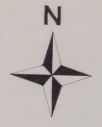
2nd question: I would like to use a northarrow as you can see in the attached file. Does anyone have some code for that?
Thanks for your help.
cheers, Torsten
_______________________________________________ Therion mailing list Therion@speleo.sk http://mailman.speleo.sk/mailman/listinfo/therion
Hi Stacho Thanks a lot for the code. Really great support. :-) Torsten
Stacho Mudrak <lists@group-s.sk> hat am 4. April 2014 um 11:02 geschrieben:
I think, the idea with variables containing coordinate extents and modification of layout should do the job. I will try to implement it, in the next snapshot.
And here is the layout code for your north arrow:
def s_northarrow (expr rot) = T:=identity; picture tmp_pic; tmp_pic = image ( begingroup interim defaultscale:=3; label.top("N", origin shifted (0,2.2cm)); endgroup; thdraw (-.4cm,.4cm)--(0,2cm)--(.4cm,.4cm)--(2cm,0cm)--(.4cm,-.4cm)--(0,-2cm)--(-.4cm,-.4cm)--(-2cm,0)--cycle; thfill (-.4cm,.4cm)--(0,2cm)--(0,0)--cycle; thfill (.4cm,-.4cm)--(0,-2cm)--(0,0)--cycle; thfill (.4cm,.4cm)--(2cm,0)--(0,0)--cycle; thfill (-.4cm,-.4cm)--(-2cm,0)--(0,0)--cycle; ); draw tmp_pic scaled 0.5 rotatedaround(origin, -rot); enddef;
S.
On 3 April 2014 21:19, Bruce <bruce@tomo.co.nz> wrote:
Torsten If indeed the 'cave' you have entered has a depth range between -15m and -20m, then I would expect the depth to be reported as (+)5m. (I presume this is a sea cave, with altitudes below sea level - but it would also be OK if you are using an arbitrary altitude datum).
Same as a dry cave that starts at 100m and descends to 95m. It's depth would be reported as (+)5m, not 100m.
Maybe the solution for you is to add altitude points to the wall near each end, so that the altitudes are plotted directly on the map.
Or you could add a (manual) map-comment to the header "maximum depth: 20m"
Another idea, therion may store variables that define the maximum coordinate range. If so, then it would simply be a matter of a small metapost to report the minimum altitude. Stacho? Martin?
Bruce
-----Original Message----- From: therion-bounces@speleo.sk [mailto:therion-bounces@speleo.sk] On Behalf Of Torsten Schnitter Sent: Friday, 4 April 2014 2:28 a.m. To: therion@speleo.sk Subject: [Therion] Question about "\cavedepth" and Northarrow
Hi all
I'm wondering a bit about the results from the variable \cavedepth. May be it's not correct this way or I do have a different understanding and someone can explain to me why it is this way.
I'm drawing a map (with scraps, points, walls etc) containing just a sidepassage of the entire cavesystem. Concerining the survey data I'm using "data diving ..." within centerline.
The result from \cavedepth is now the maximum difference between the shallowest and deepest point of that part of the cave. E.g.: If I have surveypoints in this part of the cave from -15m to -20m the result in the header using \cavedepth is -5m. What I did expect to get from \cavedepth was the maximum depth of this part of the cave, so -20m. Because this is the relevant info to cavedivers.
Is there any way to get this result without using the override from \cavedepth? I would like to use the automatic calculation of course but also want to get the maximum depth under water.
2nd question: I would like to use a northarrow as you can see in the attached file. Does anyone have some code for that?
Thanks for your help.
cheers, Torsten
_______________________________________________ Therion mailing list Therion@speleo.sk http://mailman.speleo.sk/mailman/listinfo/therion
_______________________________________________ Therion mailing list Therion@speleo.sk http://mailman.speleo.sk/mailman/listinfo/therion
I think, the idea with variables containing coordinate extents and modification of layout should do the job. I will try to implement it, in the next snapshot.
Stacho, You are becoming prolific. I like it! Can I request a \thversion variable as well please, so the Bruce
Stacho Sorry I did not finish typing my last message. I'd like to request some more metapost variables that users can make use of, to make their map headers more complete. I regularly get complaints from judges at map competition time, and I refuse to 'hard code' these in my layouts, because I regularly change versions and coordinate systems, so to 'hard code' is not only duplication (I selected it in the input files and then type it again in the output layout), it also invites mistakes if I forget to change something. So, some suggestions; \thversion = the current version of therion, ie 5.3.15 (for the next version) \thoutputcs = output coordinate system code ie <null>, UTM1, or EPSG: 2193 \thoutputcsshort = output coordinate system short text ie arbitrary, UTM1, or NZTM 2000 \thoutputcslong = output coordinate system long text ie arbitrary, Universal Transverse Mercator Zone 1, or New Zealand Transverse Mercator 2000. If it would help to have someone do a menial task, I can put together a table of EPSG and ESRI codes (in english). \thnorth = grid, true or magnetic \thgeomagdeclination = the geomagnetic declination at the date of compilation (or perhaps the date of the most recent survey?) \thgridangle = similar to declination, but wrt grid north. This will allow us to define metapost north arrows that points combinations of grid, true and to magnetic north at will. _____ From: therion-bounces@speleo.sk [mailto:therion-bounces@speleo.sk] On Behalf Of Bruce Sent: Saturday, 5 April 2014 5:38 p.m. To: 'List for Therion users' Subject: Re: [Therion] Question about "\cavedepth" and Northarrow
I think, the idea with variables containing coordinate extents and modification of layout should do the job. I will try to implement it, in the next snapshot.
Stacho, You are becoming prolific. I like it! Can I request a \thversion variable as well please, so the Bruce

Been trying to get my grid looking good. I find the default crosses for my standard 100m grid about twice the size I would like. Secondly, I would then like the kilometre grid lines to be continuous like the code from Stacho and Bruce, but still with the 100m small crosses. Finally to label just the kilometre grid at its intersections but not the 100m crosses Has anyone got any meta code to help with any section of this request. John S
Maybe a straight forward approach is to adopt gridlines spaced at 1km, and label them in the usual way using standard Therion statements. Then add to the metapost example on the wiki (which draws continuous lines), to add small crosses at 0.1x grid spacing (0.1x xsize and 0.1x ysize). Not exactly sure how it will turn out around the edges, but worth a try. I'll leave the actual coding to someone who is proficient at metapost. Bruce _____ From: therion-bounces@speleo.sk [mailto:therion-bounces@speleo.sk] On Behalf Of John Stevens Sent: Monday, 7 April 2014 10:21 p.m. To: List for Therion users Subject: Re: [Therion] grid lines Been trying to get my grid looking good. I find the default crosses for my standard 100m grid about twice the size I would like. Secondly, I would then like the kilometre grid lines to be continuous like the code from Stacho and Bruce, but still with the 100m small crosses. Finally to label just the kilometre grid at its intersections but not the 100m crosses Has anyone got any meta code to help with any section of this request. John S
participants (4)
-
 Bruce
-
 John Stevens
-
 Stacho Mudrak
-
 Torsten Schnitter