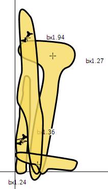
Up until now I've been creating cross-section scraps and inserting them within plan or elevation scraps using a statement like; point 331.25 -43.0 section -scrap BX-Ent2PLANxs-24 This is how I think it is usually done(?) It works fine most of the time, but sometimes the density of passages is such that the cross-section needs to be on the far side of the page, or maybe you prefer to group the cross-sections together in their own little table. This makes including the cross-section insertion points within plan or elevation scraps impractical I think. Some time back there were discussions on this forum about alternative ways of presenting cross-sections however I am not sure if they were resolved. Something in the Therion Book made me think this might give interesting results. 1. Add one or more cross-section scraps to a map (or maps) of type -projection none 2. Export those maps to a map output. So perhaps the result below is interesting, but I'm not sure how I might develop it further into a means of presenting the cross-sections where the sections are not plotted adjacent to the plan or elevation of the passage. The trouble is all the cross-section maps plot on top of each other. One way might be to export each cross-section one at a time then have lots of map-image statements to add them to a final master map. This would be a very messy th-config file. Or would a plan scrap with no associated survey, and lots of 'point x y section -scrap <scrap>' work? Has anyone tried to layout cross-sections independent of the passage without resorting to post processing? Bruce (Example below) map BX-Ent2SectionsA \ -projection none BX-Ent2PLANxs-24 BX-Ent2PLANxs-94 endmap map BX-Ent2SectionsB \ -projection none BX-Ent2PLANxs-36 BX-Ent2PLANxs-27 endmap . export map -projection none \ -layout LayoutMapThisCave \ -layout LayoutMapThisCaveElev \ -layout-scale 1 100 \ -layout-scale-bar 10 m \ -output ../Outputs/CaveSections.pdf