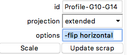
Hi Bill, it looks you have not defined „extend“ of centerline in your centerline data. Because extend right is default Therion will extend your stations form OC5a to the right, but it has to close the loop and there should be the problem. Your scrap extended Profile-OC5a-G10 includes stations OC5a to G10, stations OC5a-G are extended to East but stations C9 and C10 are extended to West. Try to divide that loop to two scraps from OC5a to G8 and G8 to G14 and add extend commands. Not use join commands for first elevation export. extend right OC5a G1 19.6 134 3.0 314 -3.0 1.0 9.8 18.7 3.5 G1 G2 20.4 133 29.0 313 -28.0 3.0 6.6 17.3 4.2 G2 G3 21.2 125 13.0 306 -13.0 2.3 3.0 9.3 6.4 G3 G4 22.6 60 4.0 239 -5.0 6.2 2.0 4.8 2.4 G4 G5 4.5 48 -10.0 228 10.0 2.6 1.7 1.2 0.3 G5 G6 12.3 101 18.0 281 -18.0 1.5 1.5 7.2 0.3 G6 G7 9.0 127 7.0 308 -7.0 7.3 16.2 5.1 2.0 G7 G8 10.9 44 -8.0 225 8.0 12.8 10.4 4.1 2.3 extend left G8 G9 8.5 335 -15.0 157 16.0 8.5 27.4 2.7 3.1 G9 G10 15.5 307 -1.0 128.5 1.0 3.4 3.9 0.7 0.8 G10 G11 32.0 267 -1.5 88.5 2.0 7.4 5.6 0.5 1.0 G11 G12 21.8 262 0.0 81 0.0 1.7 4.8 1.5 1.4 G12 G13 5.7 246 6.0 - -6.0 1.8 3.0 1.0 2.0 G13 G14 13.9 236 -61.0 57 62.0 - - - - extend hide G14 G1 5.9 - -32.0 220 32.0 - - - - flags splay G1 G1a 12.9 200 -6.0 - 6.0 20.0 20.0 17.3 4.2 G7 G7a 18.4 249 12.0 - -12.0 10.4 12.8 4.1 2.3 flags not splay Add command select to your thconfig file source StarkCaverns.th select StarkCavernsProfiles@StarkCavernsProfiles # Load the Metapost code for custom symbols and add to scrap G10-G14 (G8-G14) parameter -flip horizontal, because in output it should be flipped. Martin And after some editing:
6. 9. 2019 v 16:09, Bill Gee <bgee@campercaver.net>:
Hi Martin -
This is a commercial cave - there are no secrets! The attached ZIP file has the thconfig, .th, .th2 and centerline data files for the whole project.
-- Bill Gee
On Friday, September 6, 2019 8:50:38 AM CDT Martin Sluka via Therion wrote:
Bill,
may you publish all your data? Or send it privately?
Martin
6. 9. 2019 v 15:47, Bill Gee <bgee@campercaver.net>:
Hello everyone -
I have not been putting elevation profiles on my maps for several years because it is such a pain to do in Therion. The time has come where I need to start adding them to several maps in progress.
In the past I have defined the profile scraps as type "elevation" and given them a viewpoint angle. The profile I am working on now will not work for that because it basically goes around in a circle. There is no viewpoint angle where the entire profile lays out in a line. The plan view is a loop.
So for this one I defined the scrap as type "extended". Holy cow, that makes a mess of things! Take a look at the attached file. This is so distorted it is hard to figure out how it relates to the drawing! The stations in this profile go about 3/4 of the way around the circle. The upper half of the resulting map is upside down and magnified about 5 times larger than it should be.
What am I missing??? Do I correctly understand that an "extended" scrap should draw just the way it appears on the original sketch? How should I be drawing
Maybe I should completely skip using elevations. I can probably make them work by drawing as cross-sections. Indeed, that might be easier to fit onto the final map. I think the only real problem there is whether cross-section scraps can be joined.
_______________________________________________ Therion mailing list Therion@speleo.sk https://mailman.speleo.sk/listinfo/therion
<StarkCavernsData.zip>_______________________________________________ Therion mailing list Therion@speleo.sk https://mailman.speleo.sk/listinfo/therion