
Nick Bairstow wrote: "I have been giving some thought to producing a tutorial to follow on from Footlegs wiki item. Unfortunately it's not a simple as I first thought. Over the next few months I will attempt to come up with something that will enable a novice therioneer understand the next steps following the Footleg wiki article. It would be nice to continue using Bull Pot as the sample cave but I have not got time to re-survey that so I propose we use an existing data set which could become the default novice reference. It seems many people give up with Therion as it is difficult to learn but with a good tutorial and a little help many more could be using it. What do people think, am I wasting my time, comments please. Oh and if someone else is already doing something similar please shout up. No point doing it twice." I use Footleg's tutorial a lot. If you are not using a program every day, then having a handy known reference point for the details is always a good thing. It doesn't cover every single aspect, so if Nick wants to add further material, I for one would be delighted. Please do it, Nick. The other main trick for learning in this way is "How did we do this last time?" or looking back at a previous data set, your own or someone else's, and seeing how it works. If there was a reference data set available (if not on the Therion wiki but on the cave-registry page, perhaps) then the tutorial could certainly link to that. Of course 'live' data can change over time, so having a fixed example set might be better. Bear in mind that data for a single cave is insufficient to cover all problems. We routinely combine data from different caves, because they are close together or, as has been done several times, to produce a context overview to show a cave in relation to its neighbours and the land surface. See, for example, the thing below the caption in the latest version of the Gough's Cave survey http://www.ubss.org.uk/resources/surveys/survex/Goughs_all.pdf . Does anyone have a good multi-cave dataset that is now stable and so can be used for this purpose? It is also worth remembering, of course, that different people do some things differently, an example data set might enshrine work habits that are not the same as mine or yours. Graham

In my opinion - and I'm repeating myself here - people give up because of the unfriendly command line environment. A windows-type interface with radio buttons and drop down menus would be much easier to use and remember. Please can the programmers work at this aspect instead of tweaking the underlying code? I don't think that yet another tutorial will help the majority of potential users. On 6 Sep 2015 07:18, Graham Mullan <graham.mullan@coly.org.uk> wrote:
Nick Bairstow wrote:
"I have been giving some thought to producing a tutorial to follow on from Footlegs wiki item. Unfortunately it's not a simple as I first thought. Over the next few months I will attempt to come up with something that will enable a novice therioneer understand the next steps following the Footleg wiki article. It would be nice to continue using Bull Pot as the sample cave but I have not got time to re-survey that so I propose we use an existing data set which could become the default novice reference. It seems many people give up with Therion as it is difficult to learn but with a good tutorial and a little help many more could be using it. What do people think, am I wasting my time, comments please. Oh and if someone else is already doing something similar please shout up. No point doing it twice."
I use Footleg's tutorial a lot. If you are not using a program every day, then having a handy known reference point for the details is always a good thing. It doesn't cover every single aspect, so if Nick wants to add further material, I for one would be delighted. Please do it, Nick.
The other main trick for learning in this way is "How did we do this last time?" or looking back at a previous data set, your own or someone else's, and seeing how it works. If there was a reference data set available (if not on the Therion wiki but on the cave-registry page, perhaps) then the tutorial could certainly link to that. Of course 'live' data can change over time, so having a fixed example set might be better. Bear in mind that data for a single cave is insufficient to cover all problems. We routinely combine data from different caves, because they are close together or, as has been done several times, to produce a context overview to show a cave in relation to its neighbours and the land surface. See, for example, the thing below the caption in the latest version of the Gough's Cave survey http://www.ubss.org.uk/resources/surveys/survex/Goughs_all.pdf . Does anyone have a good multi-cave dataset that is now stable and so can be used for this purpose?
It is also worth remembering, of course, that different people do some things differently, an example data set might enshrine work habits that are not the same as mine or yours.
Graham
_______________________________________________ Therion mailing list Therion@speleo.sk http://mailman.speleo.sk/mailman/listinfo/therion

There is possibility to use right click in map editor which helps much there yet. The data editor is as is, there are several tools you may use to prepare data for therion. But to tune up the data structure you need line text format anyway. The same for archiving your data. Plain text format is human readable and one may interprets it with piece of graph paper, protractor and ruler in extreme situation. The same for maps. The output compilation editor is the same case, there are so many possibilities, tricks, modifications of codes etc. it is not possible to use any an usable windows-like menus. There is possibility to define default layouts and then use these layouts as blocks or inputs without modifications there. Imagine you may to use full potential of very very powerful software tools MetaPost for definition of symbols and for workaround with scraps and TeX for definition of exported maps and atlases. These programs are behind the Therion. For error analysis you may use Survex log and for visual identification of problem "debug on“ command in layout in compilation. etc. But there is not any other tool to archive data from surveys and produce maps of complicated in many levels existed cave systems. To make a simple map of a simple cave you may in many ways. But to create an usable map of real maze cave system there is only one solution. And because any simple cave may be changed to a big maze after an exploration, … :) The Therion package is free and multi platform! Maybe you’ll find a programer which will be able to proof I’m not right. Martin
7. 9. 2015 v 8:46, Juan Corrin <uzueka@aol.com>:
In my opinion - and I'm repeating myself here - people give up because of the unfriendly command line environment. A windows-type interface with radio buttons and drop down menus would be much easier to use and remember. Please can the programmers work at this aspect instead of tweaking the underlying code? I don't think that yet another tutorial will help the majority of potential users.
On 6 Sep 2015 07:18, Graham Mullan <graham.mullan@coly.org.uk> wrote:
Nick Bairstow wrote:
"I have been giving some thought to producing a tutorial to follow on from Footlegs wiki item. Unfortunately it's not a simple as I first thought. Over the next few months I will attempt to come up with something that will enable a novice therioneer understand the next steps following the Footleg wiki article. It would be nice to continue using Bull Pot as the sample cave but I have not got time to re-survey that so I propose we use an existing data set which could become the default novice reference. It seems many people give up with Therion as it is difficult to learn but with a good tutorial and a little help many more could be using it. What do people think, am I wasting my time, comments please. Oh and if someone else is already doing something similar please shout up. No point doing it twice."
I use Footleg's tutorial a lot. If you are not using a program every day, then having a handy known reference point for the details is always a good thing. It doesn't cover every single aspect, so if Nick wants to add further material, I for one would be delighted. Please do it, Nick.
The other main trick for learning in this way is "How did we do this last time?" or looking back at a previous data set, your own or someone else's, and seeing how it works. If there was a reference data set available (if not on the Therion wiki but on the cave-registry page, perhaps) then the tutorial could certainly link to that. Of course 'live' data can change over time, so having a fixed example set might be better. Bear in mind that data for a single cave is insufficient to cover all problems. We routinely combine data from different caves, because they are close together or, as has been done several times, to produce a context overview to show a cave in relation to its neighbours and the land surface. See, for example, the thing below the caption in the latest version of the Gough's Cave survey http://www.ubss.org.uk/resources/surveys/survex/Goughs_all.pdf . Does anyone have a good multi-cave dataset that is now stable and so can be used for this purpose?
It is also worth remembering, of course, that different people do some things differently, an example data set might enshrine work habits that are not the same as mine or yours.
Graham
_______________________________________________ Therion mailing list Therion@speleo.sk http://mailman.speleo.sk/mailman/listinfo/therion
_______________________________________________ Therion mailing list Therion@speleo.sk http://mailman.speleo.sk/mailman/listinfo/therion
There's no doubting the powerful and useful nature of Therion. It is almost indispensable when surveying large and complex systems. My only point is the poor interface that requires most users to re-learn the system. There must be a programmer or programmers out there who are up to the task of producing a more user-friendly interface? It seems daft to me that enthusiastic surveyors are not using the software because of its complicated front end. Regards Juan -----Original Message----- From: Martin Sluka <martinsluka@mac.com> To: List for Therion users <therion@speleo.sk> Sent: Sun, Sep 6, 2015 9:25 am Subject: Re: [Therion] Therion tutorial There is possibility to use right click in map editor which helps much there yet. The data editor is as is, there are several tools you may use to prepare data for therion. But to tune up the data structure you need line text format anyway. The same for archiving your data. Plain text format is human readable and one may interprets it with piece of graph paper, protractor and ruler in extreme situation. The same for maps. The output compilation editor is the same case, there are so many possibilities, tricks, modifications of codes etc. it is not possible to use any an usable windows-like menus. There is possibility to define default layouts and then use these layouts as blocks or inputs without modifications there. Imagine you may to use full potential of very very powerful software tools MetaPost for definition of symbols and for workaround with scraps and TeX for definition of exported maps and atlases. These programs are behind the Therion. For error analysis you may use Survex log and for visual identification of problem "debug on“ command in layout in compilation. etc. But there is not any other tool to archive data from surveys and produce maps of complicated in many levels existed cave systems. To make a simple map of a simple cave you may in many ways. But to create an usable map of real maze cave system there is only one solution. And because any simple cave may be changed to a big maze after an exploration, … :) The Therion package is free and multi platform! Maybe you’ll find a programer which will be able to proof I’m not right. Martin
7. 9. 2015 v 8:46, Juan Corrin <uzueka@aol.com>:
In my opinion - and I'm repeating myself here - people give up because of the unfriendly command line environment. A windows-type interface with radio buttons and drop down menus would be much easier to use and remember. Please can the programmers work at this aspect instead of tweaking the underlying code? I don't think that yet another tutorial will help the majority of potential users.
On 6 Sep 2015 07:18, Graham Mullan <graham.mullan@coly.org.uk> wrote:
Nick Bairstow wrote:
"I have
been giving some thought to producing a tutorial to follow on from
Footlegs wiki item. Unfortunately it's not a simple as I first thought. Over the next few months I will attempt to come up with something that will enable a novice therioneer understand the next steps following the Footleg wiki article. It would be nice to continue using Bull Pot as the sample cave but I have not got time to re-survey that so I propose we use an existing data set which could become the default novice reference. It seems many people give up with Therion as it is difficult to learn but with a good tutorial and a little help many more could be using it. What do people think, am I wasting my time, comments please. Oh and if someone else is already doing something similar please shout up. No point doing it twice."
I use Footleg's tutorial a lot. If you are not using a program every day, then having a handy known reference point for the details is always a good thing. It doesn't cover every single aspect, so if Nick wants to add further
material, I for one would be delighted. Please do it, Nick.
The other
main trick for learning in this way is "How did we do this last
time?" or looking back at a previous data set, your own or someone else's, and seeing how it works. If there was a reference data set available (if not on the Therion wiki but on the cave-registry page, perhaps) then the tutorial could certainly link to that. Of course 'live' data can change over time, so having a fixed example set might be better. Bear in mind that data for a single cave is insufficient to cover all problems. We routinely combine data from different caves, because they are close together or, as has been done several times, to produce a context overview to show a cave in relation to its neighbours and the land surface. See, for example, the thing below the caption in the latest version of the Gough's Cave survey
http://www.ubss.org.uk/resources/surveys/survex/Goughs_all.pdf . Does
anyone have a good multi-cave dataset that is now stable and so can be used
for this purpose?
It is also worth remembering, of course, that
different people do some
things differently, an example data set might enshrine work habits that are not the same as mine or yours.
Graham
_______________________________________________ Therion
mailing list
Therion@speleo.sk
_______________________________________________
Therion mailing list
Therion@speleo.sk
http://mailman.speleo.sk/mailman/listinfo/therion _______________________________________________ Therion mailing list Therion@speleo.sk http://mailman.speleo.sk/mailman/listinfo/therion
6. 9. 2015 v 11:50, Juan Corrin <uzueka@aol.com>:
It seems daft to me that enthusiastic surveyors are not using the software because of its complicated front end.
Again: 1. try to imagine format of data for all kinds of surveying technologies available, with preserving the original format of data and include all the logs and notes around. Try imagine such windows only editor. 2. try to imagine map editor you may use any kind of vector symbol you are able to imagine. 3. try to imagine export command to export all the kinds of PDF outputs you may imagine, and export all the format therion is able to export. The problem is not the therion itself, problem is the complexity of documentation of caves. If somebody have to make a map of cave for himself and for his group, he may use what he want. If he will want to make complex documentation of cave and preserve it for feature, independent of computer platform, computers as well, … he has only one choice. One may use therion in very, very simple way, without 99 % of its complexity. So maybe much better is to start from this point. Use simple file 123.th: survey 123 input 123.th2 centerline …. encenterline map 123.map …. endmap ensurvey file 123.th2: small simple scraps in map editor. In compiler part use simple: source 123.th <http://123.th/> select 123.map export map export model Enough simple for newbies, isn’t it. Martin

Martin, today, yes it is simple. 3 weeks ago no it wasn't, I didn't have a clue what you have done there or more importantly why. Also throw in naming conventions and file structure then absolutely no chance of getting it correct, for me anyway. This is part of what I think needs covering. Nick. ________________________________________ From: therion-bounces@speleo.sk [therion-bounces@speleo.sk] On Behalf Of Martin Sluka [martinsluka@mac.com] Sent: Sunday, September 06, 2015 11:58 AM To: List for Therion users Subject: Re: [Therion] Therion tutorial 6. 9. 2015 v 11:50, Juan Corrin <uzueka@aol.com<mailto:uzueka@aol.com>>: It seems daft to me that enthusiastic surveyors are not using the software because of its complicated front end. Again: 1. try to imagine format of data for all kinds of surveying technologies available, with preserving the original format of data and include all the logs and notes around. Try imagine such windows only editor. 2. try to imagine map editor you may use any kind of vector symbol you are able to imagine. 3. try to imagine export command to export all the kinds of PDF outputs you may imagine, and export all the format therion is able to export. The problem is not the therion itself, problem is the complexity of documentation of caves. If somebody have to make a map of cave for himself and for his group, he may use what he want. If he will want to make complex documentation of cave and preserve it for feature, independent of computer platform, computers as well, … he has only one choice. One may use therion in very, very simple way, without 99 % of its complexity. So maybe much better is to start from this point. Use simple file 123.th<http://123.th>: survey 123 input 123.th2 centerline …. encenterline map 123.map …. endmap ensurvey file 123.th2: small simple scraps in map editor. In compiler part use simple: source 123.th<http://123.th> select 123.map export map export model Enough simple for newbies, isn’t it. Martin
6. 9. 2015 v 13:19, Nick Bairstow <Nick@pff.uk.com>:
Martin, today, yes it is simple. 3 weeks ago no it wasn't, I didn't have a clue what you have done there or more importantly why. Also throw in naming conventions and file structure then absolutely no chance of getting it correct, for me anyway. This is part of what I think needs covering.
Simplest way: folder: cave_123 123.th 123.th2 123.thconfig 123.txt (from PocketTopo) or 123.jpg (scan of surveying book) or 123.xls … cave.pdf cave.lox from this you may start. m.s.

or: big cave (folder) ..data (.th, th2, config, other data) ..images (sketches, jpg, xvi, corel, svg....) ..output (pdf, lox, xvi, sql...) ..topo (.top, .dxf, .txt) it is all Radek www.estavela.cz

There are many ways to arrange data, and although I set up a system, at times I do have to break it. Surveying is simple at a low level, but is amazing what happens when you combine lots of simple things. We, the people who deliver paperless surveying courses, (nomaly csg) have played with the idea of a course part 2. Usual deal; we will deliver, but organisation is done by others. Welsh caving, Cambrian I believe, has expressed interest, there is probably enough uk based surveyors who have done the introduction, to run this now. Footleg wrote his tutorial as, notes when he attended the second course I ran, hence a little out of date now. Maybe running a more advanced course on putting projects together and data management is the best place to write the tutorial, each trainee taking notes for different sections. We cam discuss this if people turn up to the csg agm at Hidden Earth at the end of the month, reminds me, must get an agenda out. Also at HE I will be running a workshop for trouble shooting surveying problems, hopefully some other people with knowledge will also be press ganged into service. (Sorry last bit of this is uk based, but a tutorial may emerge) Andrew On 6 Sep 2015 5:43 pm, "Radek" <Raadjaa@seznam.cz> wrote:
or:
big cave (folder) ..data (.th, th2, config, other data) ..images (sketches, jpg, xvi, corel, svg....) ..output (pdf, lox, xvi, sql...) ..topo (.top, .dxf, .txt)
it is all
Radek www.estavela.cz
_______________________________________________ Therion mailing list Therion@speleo.sk http://mailman.speleo.sk/mailman/listinfo/therion
6. 9. 2015 v 19:12, Andrew Atkinson <andrew@wotcc.org.uk>:
There are many ways to arrange data, and although I set up a system, at times I do have to break it. Surveying is simple at a low level, but is amazing what happens when you combine lots of simple things.
To call or „input“ a file it is used normal system path. To call an object from survey or scrap or map it is used a special path, something as mail address: object@survey.survey_higher_lever.survey_more_higher_level etc. From my poit of view is best way to make one survey/endsurvey with one centerline for one survey trip and defining base map in the same level. What is quite helpful in base level therion with simple "export map“ command in thconfig will generate pdf map from all data available for therion in that base level. So if you input th2 file with scraps in that base survey/endsurvey it will generate map from that scraps. It is very easy way, if you want to check the scraps drawn. But is is not the best way for the future work in higher levels of surveys or maps. So I always define one or more maps in base level too and I strictly use command „select“ the particular map in thconfig. I don’t use any kind of index.th file with input 123.th and input 123.th2 concurrently, simple because it is necessary to rename station points in base level scraps. Each higher level map definition will use path to base level scraps or maps. It is quite enough typing but there exists copy/paste fortunately. m.s.
Very important: The structure os surveys and structure of maps if absolutely independent. m.s.
Enough simple for newbies, isn’t it. ?! No ?! -----Original Message----- From: Martin Sluka <martinsluka@mac.com> To: List for Therion users <therion@speleo.sk> Sent: Sun, Sep 6, 2015 11:58 am Subject: Re: [Therion] Therion tutorial 6. 9. 2015 v 11:50, Juan Corrin < uzueka@aol.com>: It seems daft to me that enthusiastic surveyors are not using the software because of its complicated front end. Again: 1. try to imagine format of data for all kinds of surveying technologies available, with preserving the original format of data and include all the logs and notes around. Try imagine such windows only editor. 2. try to imagine map editor you may use any kind of vector symbol you are able to imagine. 3. try to imagine export command to export all the kinds of PDF outputs you may imagine, and export all the format therion is able to export. The problem is not the therion itself, problem is the complexity of documentation of caves. If somebody have to make a map of cave for himself and for his group, he may use what he want. If he will want to make complex documentation of cave and preserve it for feature, independent of computer platform, computers as well, … he has only one choice. One may use therion in very, very simple way, without 99 % of its complexity. So maybe much better is to start from this point. Use simple file 123.th: survey 123 input 123.th2 centerline …. encenterline map 123.map …. endmap ensurvey file 123.th2: small simple scraps in map editor. In compiler part use simple: source 123.th select 123.map export map export model Enough simple for newbies, isn’t it. Martin _______________________________________________ Therion mailing list Therion@speleo.sk http://mailman.speleo.sk/mailman/listinfo/therion
I think Graham is thinking along the same lines as me. A stable data set which covers a bit of everything is whats needed but with tutorials to cover the different aspects of the build. Juan a windows type GUI would be great but if what Martin says is correct the Therion is what it is. As a new user I don't have a problem with how it works once someone showed me the way. It's quite straight forward and no more difficult to learn than the two new cad programs I am currently getting to grips with. I will admit the th2 files get a bit confusing at times - how about different colours for different line types- but once you get your work flow under control then it's not difficult. I am an average PC user and all this MetaTex stuff is a mystery. I just copy what others have shown me, as time goes on I will learn more but at the moment I am producing maps which is all I want. Actually I want a 3d model with a surface overlay for our whole system but one step a time. The tutorials available, apart from Footlegs, we have found hard to follow and to be honest we made little progress following them, sorry. My reference now is the data that Dave Clucas has helped me with and when I show this and explain it to my mates who have more or less given up with Therion I am sure they will start using the software again. Yesterday afternoon I got Thursday nights data into the main plan all joined to the system in under 2 hours, 3 weeks ago I did not have a clue how to do that. This is the secondary level of knowledge we should aim to cover with this tutorial. I suspect the biggest issue will be which is the best way to do things, as an engineer my mantra is keep it simple, simple, simple as it always works best. It can always be made more complex once you understand what you are doing. Bruce, I believe your comment is correct which is why I want to start this now. and you're right I will need help. I might add this is something that I would normally avoid getting involved with but I am really starting to get into this surveying game and by my reasoning the more people using the software especially locally the quicker I will learn more. Selfish interest I'm afraid. Any Therion novice lurkers out there with anything to say. Nick. ________________________________________ From: therion-bounces@speleo.sk [therion-bounces@speleo.sk] On Behalf Of Martin Sluka [martinsluka@mac.com] Sent: Sunday, September 06, 2015 9:25 AM To: List for Therion users Subject: Re: [Therion] Therion tutorial There is possibility to use right click in map editor which helps much there yet. The data editor is as is, there are several tools you may use to prepare data for therion. But to tune up the data structure you need line text format anyway. The same for archiving your data. Plain text format is human readable and one may interprets it with piece of graph paper, protractor and ruler in extreme situation. The same for maps. The output compilation editor is the same case, there are so many possibilities, tricks, modifications of codes etc. it is not possible to use any an usable windows-like menus. There is possibility to define default layouts and then use these layouts as blocks or inputs without modifications there. Imagine you may to use full potential of very very powerful software tools MetaPost for definition of symbols and for workaround with scraps and TeX for definition of exported maps and atlases. These programs are behind the Therion. For error analysis you may use Survex log and for visual identification of problem "debug on“ command in layout in compilation. etc. But there is not any other tool to archive data from surveys and produce maps of complicated in many levels existed cave systems. To make a simple map of a simple cave you may in many ways. But to create an usable map of real maze cave system there is only one solution. And because any simple cave may be changed to a big maze after an exploration, … :) The Therion package is free and multi platform! Maybe you’ll find a programer which will be able to proof I’m not right. Martin
7. 9. 2015 v 8:46, Juan Corrin <uzueka@aol.com>:
In my opinion - and I'm repeating myself here - people give up because of the unfriendly command line environment. A windows-type interface with radio buttons and drop down menus would be much easier to use and remember. Please can the programmers work at this aspect instead of tweaking the underlying code? I don't think that yet another tutorial will help the majority of potential users.
On 6 Sep 2015 07:18, Graham Mullan <graham.mullan@coly.org.uk> wrote:
Nick Bairstow wrote:
"I have been giving some thought to producing a tutorial to follow on from Footlegs wiki item. Unfortunately it's not a simple as I first thought. Over the next few months I will attempt to come up with something that will enable a novice therioneer understand the next steps following the Footleg wiki article. It would be nice to continue using Bull Pot as the sample cave but I have not got time to re-survey that so I propose we use an existing data set which could become the default novice reference. It seems many people give up with Therion as it is difficult to learn but with a good tutorial and a little help many more could be using it. What do people think, am I wasting my time, comments please. Oh and if someone else is already doing something similar please shout up. No point doing it twice."
I use Footleg's tutorial a lot. If you are not using a program every day, then having a handy known reference point for the details is always a good thing. It doesn't cover every single aspect, so if Nick wants to add further material, I for one would be delighted. Please do it, Nick.
The other main trick for learning in this way is "How did we do this last time?" or looking back at a previous data set, your own or someone else's, and seeing how it works. If there was a reference data set available (if not on the Therion wiki but on the cave-registry page, perhaps) then the tutorial could certainly link to that. Of course 'live' data can change over time, so having a fixed example set might be better. Bear in mind that data for a single cave is insufficient to cover all problems. We routinely combine data from different caves, because they are close together or, as has been done several times, to produce a context overview to show a cave in relation to its neighbours and the land surface. See, for example, the thing below the caption in the latest version of the Gough's Cave survey http://www.ubss.org.uk/resources/surveys/survex/Goughs_all.pdf . Does anyone have a good multi-cave dataset that is now stable and so can be used for this purpose?
It is also worth remembering, of course, that different people do some things differently, an example data set might enshrine work habits that are not the same as mine or yours.
Graham
_______________________________________________ Therion mailing list Therion@speleo.sk http://mailman.speleo.sk/mailman/listinfo/therion
_______________________________________________ Therion mailing list Therion@speleo.sk http://mailman.speleo.sk/mailman/listinfo/therion
_______________________________________________ Therion mailing list Therion@speleo.sk http://mailman.speleo.sk/mailman/listinfo/therion

I've been thinking along much the same lines regarding my tutorial, as I have increased my knowledge of Therion somewhat since I wrote to original. I started work on a new version earlier in the year, based on a more suitable data set which would enable me to cover more Therion skills with less drawing and expand into some of the areas I was unsure about when I wrote the original. I also tried to incorporate details of all the common pitfalls I have observer trainees fall into on the training courses we have run in recent years in the UK. I've not got back to continue work on this tutorial since March (I took a break to actually do some survey drawing up) so rather than sit on this longer, I have posted a link to the current draft on the Documentation section of the wiki. Or you can find it directly from this link: http://wscc.darkgem.com/footleg/therion/ I would welcome any feedback on this new revision. If you spot any errors or omissions of course, but particularly please let me know what Therion knowledge is not covered which you think is important to progress further. Great to hear that the original tutorial has proved so useful. I hope this revision can make it even more valuable to people. Footleg On Sun, Sep 6, 2015 at 7:19 AM Graham Mullan <graham.mullan@coly.org.uk> wrote:
Nick Bairstow wrote:
"I have been giving some thought to producing a tutorial to follow on from Footlegs wiki item. Unfortunately it's not a simple as I first thought. Over the next few months I will attempt to come up with something that will enable a novice therioneer understand the next steps following the Footleg wiki article. It would be nice to continue using Bull Pot as the sample cave but I have not got time to re-survey that so I propose we use an existing data set which could become the default novice reference. It seems many people give up with Therion as it is difficult to learn but with a good tutorial and a little help many more could be using it. What do people think, am I wasting my time, comments please. Oh and if someone else is already doing something similar please shout up. No point doing it twice."
I use Footleg's tutorial a lot. If you are not using a program every day, then having a handy known reference point for the details is always a good thing. It doesn't cover every single aspect, so if Nick wants to add further material, I for one would be delighted. Please do it, Nick.
The other main trick for learning in this way is "How did we do this last time?" or looking back at a previous data set, your own or someone else's, and seeing how it works. If there was a reference data set available (if not on the Therion wiki but on the cave-registry page, perhaps) then the tutorial could certainly link to that. Of course 'live' data can change over time, so having a fixed example set might be better. Bear in mind that data for a single cave is insufficient to cover all problems. We routinely combine data from different caves, because they are close together or, as has been done several times, to produce a context overview to show a cave in relation to its neighbours and the land surface. See, for example, the thing below the caption in the latest version of the Gough's Cave survey http://www.ubss.org.uk/resources/surveys/survex/Goughs_all.pdf . Does anyone have a good multi-cave dataset that is now stable and so can be used for this purpose?
It is also worth remembering, of course, that different people do some things differently, an example data set might enshrine work habits that are not the same as mine or yours.
Graham _______________________________________________ Therion mailing list Therion@speleo.sk http://mailman.speleo.sk/mailman/listinfo/therion
7. 9. 2015 v 11:27, Footleg <drfootleg@gmail.com>:
I would welcome any feedback on this new revision.
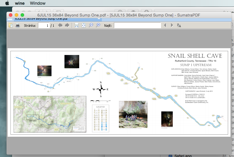
I just checked Sumatra on MacOSX as Wine application made by WineBottler. It works well. The same with Notepad++. I’m not able to bottled PocketTopo only. If somebody may help with it, please. m.s.
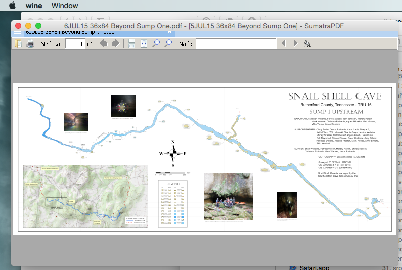

Hi Martin, If it is possible, I would like to have the thconfig file witch you have used for that well looking plan. I’ am sure, I will learn a lot from that to make better plans with Therion. I’ am more a learner by doing, so it would help ☺. Regards Markus Von: therion-bounces@speleo.sk [mailto:therion-bounces@speleo.sk] Im Auftrag von Martin Sluka (External) Gesendet: Montag, 7. September 2015 22:22 An: List for Therion users Betreff: Re: [Therion] Therion tutorial 7. 9. 2015 v 11:27, Footleg <drfootleg@gmail.com<mailto:drfootleg@gmail.com>>: I would welcome any feedback on this new revision. I just checked Sumatra on MacOSX as Wine application made by WineBottler. It works well. The same with Notepad++. I’m not able to bottled PocketTopo only. If somebody may help with it, please. m.s. [cid:image001.png@01D0EA11.FC04C8E0] This message is intended solely for the designated recipient(s). It may contain confidential or proprietary information and may be subject to attorney-client privilege or other confidentiality protections. If you are not a designated recipient you may not review, copy or distribute this message. If you receive this in error, please notify the sender by reply e-mail and delete this message. Thank you. Diese Nachricht ist nur für vorgesehene Empfänger bestimmt. Die Nachricht kann vertrauliche oder persönliche Informationen enthalten und kann datenschutzrechtlichen Bestimmungen unterliegen. Wenn Sie kein vorgesehener Empfänger dieser Nachricht sind, ist es Ihnen untersagt, die darin enthaltenen Informationen einzusehen, zu vervielfältigen und zu veröffentlichen. Sollten Sie diese Nachricht versehentlich erhalten, bitten wir Sie, den Sender zu informieren, indem Sie auf diese Nachricht antworten und die Nachricht dann löschen. Vielen Dank.
participants (8)
-
 Andrew Atkinson
-
 Footleg
-
 Graham Mullan
-
 Juan Corrin
-
 Markus Boldt
-
 Martin Sluka
-
 Nick Bairstow
-
 Radek