
Hello fellows, I've faced a problem when I started to use therion for the surveys we do. The matter is that when we survey a vertical passage (a well) we are used to take such sets of measurements: shot from-to, length(vertical) and 3-5 combinations of azimuth and distance. Ex. 1-2 5m. (210' - 1,2m)(0' - 4m)(75' - 3m)(160' - 0m) 210' stands for 210 degrees etc. And I cannot find out how using syntax of therion to note these measurements. Or should I change the way I do notes. Thanks for any ideas and advises. Vilius A. Speleoclub "Ænigma" www.speleo.lt

Vilius A wrote:
I've faced a problem when I started to use therion for the surveys we do. The matter is that when we survey a vertical passage (a well) we are used to take such sets of measurements: shot from-to, length(vertical) and 3-5 combinations of azimuth and distance. Ex. 1-2 5m. (210' - 1,2m)(0' - 4m)(75' - 3m)(160' - 0m) 210' stands for 210 degrees etc.
Do you have some idea, where would you like to use these data? As far as I can see, if you will specify cross section that way, it can be used in 3D model (with a very special 3D generation algorithm designed to us these data). And some of these points could be used when plan or elevatn is drawn. Do you use them for something else? And why not to give to these points some names and specify them as ordinary stations? May be with "duplicate" flag? Normally, when you specify LRUD data for vertical shot - it is in fact West - East - North - South and that way it is used in 3D model. Would like to have possibility to specify passage dimension in arbitrary direction (not only LRUD)? Regards, S.
On 7/27/07, Stacho Mudrak <s.m@group-s.sk> wrote:
Vilius A wrote:
I've faced a problem when I started to use therion for the surveys we do. The matter is that when we survey a vertical passage (a well) we are used to take such sets of measurements: shot from-to, length(vertical) and 3-5 combinations of azimuth and distance. Ex. 1-2 5m. (210' - 1,2m)(0' - 4m)(75' - 3m)(160' - 0m) 210' stands for 210 degrees etc.
Do you have some idea, where would you like to use these data?
As far as I can see, if you will specify cross section that way, it can be used in 3D model (with a very special 3D generation algorithm designed to us these data). And some of these points could be used when plan or elevatn is drawn. Do you use them for something else?
And why not to give to these points some names and specify them as ordinary stations? May be with "duplicate" flag?
Normally, when you specify LRUD data for vertical shot - it is in fact West - East - North - South and that way it is used in 3D model. Would like to have possibility to specify passage dimension in arbitrary direction (not only LRUD)?
Regards, S.
_______________________________________________ Therion mailing list Therion@speleo.sk http://www.speleo.sk/mailman/listinfo/therion
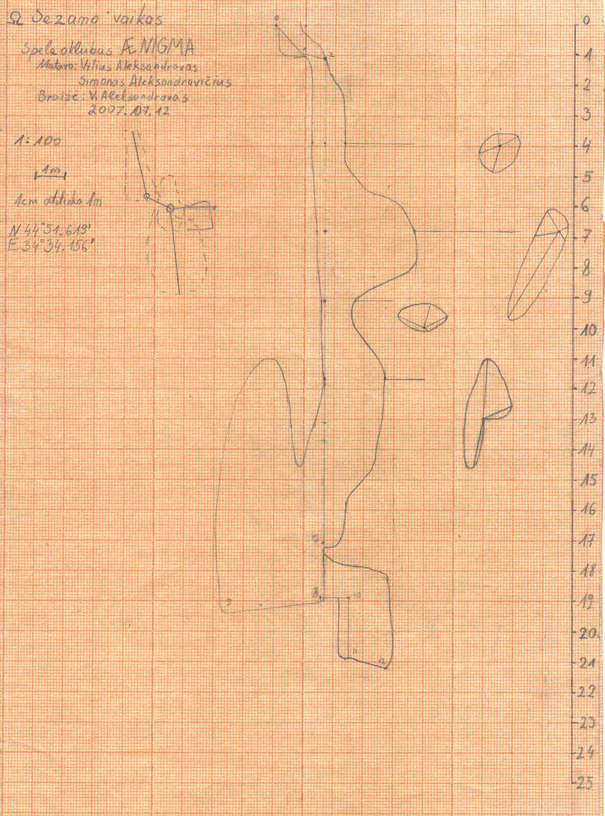
Sorry for late answer. Actually, we use such data drawing xelevations. Its useful to draw a small plan of a vertical passage close to the same place in a xelevaton. It would be nice to have such function in therion though it's not highly important. I attach an example of a simple cave An other thing - we have already done several surveys of some caves the way I mentioned. So it would be good to enter the data to some software the same way. Vilius A Speleoclub "Ænigma" www.speleo.lt
Vilyzzz wrote:
Actually, we use such data drawing xelevations. Its useful to draw a small plan of a vertical passage close to the same place in a xelevaton. It would be nice to have such function in therion though it's not highly important.
OK, I think now I know what you mean. This small plan is in fact a cross section - and also other people were asking to show LRUD information for specified survey station in map editor to support cross section drawing. I think it is possible to do it, but it will take some time.
I attach an example of a simple cave An other thing - we have already done several surveys of some caves the way I mentioned. So it would be good to enter the data to some software the same way.
I will think about syntax, it would be good to allow such generic cross section specification (directions + distance) also in other projections. S.
participants (3)
-
 Stacho Mudrak
-
 Vilius A
-
Vilyzzz