
Hello. I like to have cave maps colored by altitude. I think color is an important piece of information, especially in plant layouts. As far as I know, Therion is able to color on scrap basis only. Because I also like to have the same color in the same piece of cave either in elevation and plant map, I usually split scraps at the same borders in both projections. This is quite cumbersome and time consuming. Also, there's no practical way to do such a split when trying to draw on a touch screen while hanging up from a rope.. So I'm proposing a solution: is it possible to split scraps offline based on altitude? I'm thinking about a script which takes a (series of) .th2 file as its input, and generates another .th2 file containing no scraps deeper than, say, M meters. Scraps with stations whose vertical distance exceeds M should be split in two or more scraps. Areas, lines and other symbols should be connected (if possible) across scraps. Using a script like that, one could push M around to zero and get a cave filled with something like a color gradient, which could be wonderful. Is that a crazy idea? ;-) Marco

Hello Marco, The 'map-fg' layout command instructs therion to color scraps based on the (I believe) average value of station altitudes in a given scrap. A scrap will have one color, but neighboring scraps will differ if their average altitude differs. Perhaps this functionality will suit your needs. Best regards, Jonny --- Please excuse my brevity, I am responding from my phone. On Jun 28, 2016 09:17, "Marco Menchise" <marco.menchise@gmail.com> wrote:
Hello.
I like to have cave maps colored by altitude. I think color is an important piece of information, especially in plant layouts.
As far as I know, Therion is able to color on scrap basis only. Because I also like to have the same color in the same piece of cave either in elevation and plant map, I usually split scraps at the same borders in both projections.
This is quite cumbersome and time consuming. Also, there's no practical way to do such a split when trying to draw on a touch screen while hanging up from a rope..
So I'm proposing a solution: is it possible to split scraps offline based on altitude? I'm thinking about a script which takes a (series of) .th2 file as its input, and generates another .th2 file containing no scraps deeper than, say, M meters. Scraps with stations whose vertical distance exceeds M should be split in two or more scraps. Areas, lines and other symbols should be connected (if possible) across scraps.
Using a script like that, one could push M around to zero and get a cave filled with something like a color gradient, which could be wonderful.
Is that a crazy idea? ;-)
Marco
_______________________________________________ Therion mailing list Therion@speleo.sk http://mailman.speleo.sk/mailman/listinfo/therion
I should add that page 54 of the therion book describes map-fg usage, including the altitude parameter. Best regards, Jonny --- Please excuse my brevity, I am responding from my phone. On Jun 28, 2016 09:56, "Jonny Prouty" <jonathanprouty@gmail.com> wrote:
Hello Marco,
The 'map-fg' layout command instructs therion to color scraps based on the (I believe) average value of station altitudes in a given scrap. A scrap will have one color, but neighboring scraps will differ if their average altitude differs. Perhaps this functionality will suit your needs.
Best regards,
Jonny
---
Please excuse my brevity, I am responding from my phone. On Jun 28, 2016 09:17, "Marco Menchise" <marco.menchise@gmail.com> wrote:
Hello.
I like to have cave maps colored by altitude. I think color is an important piece of information, especially in plant layouts.
As far as I know, Therion is able to color on scrap basis only. Because I also like to have the same color in the same piece of cave either in elevation and plant map, I usually split scraps at the same borders in both projections.
This is quite cumbersome and time consuming. Also, there's no practical way to do such a split when trying to draw on a touch screen while hanging up from a rope..
So I'm proposing a solution: is it possible to split scraps offline based on altitude? I'm thinking about a script which takes a (series of) .th2 file as its input, and generates another .th2 file containing no scraps deeper than, say, M meters. Scraps with stations whose vertical distance exceeds M should be split in two or more scraps. Areas, lines and other symbols should be connected (if possible) across scraps.
Using a script like that, one could push M around to zero and get a cave filled with something like a color gradient, which could be wonderful.
Is that a crazy idea? ;-)
Marco
_______________________________________________ Therion mailing list Therion@speleo.sk http://mailman.speleo.sk/mailman/listinfo/therion

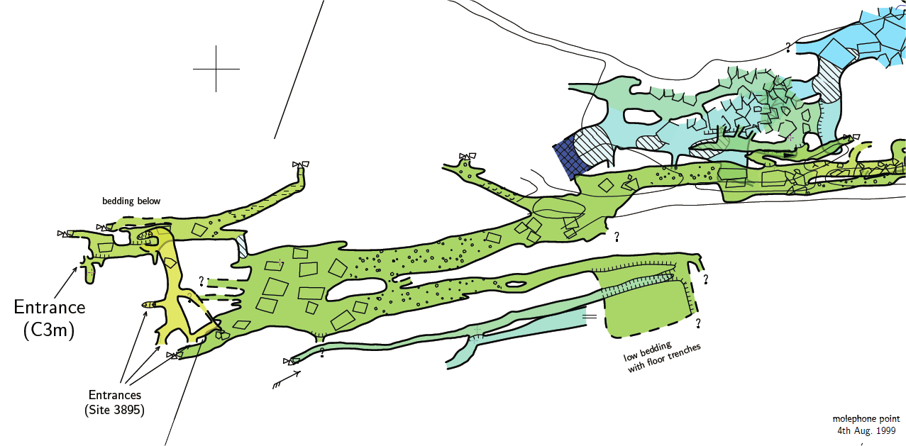
I generate my maps using the colour by altitude (in the plans). I just break my scraps wherever the altitude of the stations changes significantly for the cave I am drawing. I pin the min and max altitude used for the colour scale using invisible dummy stations fixed as specific altitudes, so the colours do not keep changing as I draw more scraps. I try hard to hide my scrap borders with pitch or floor step lines, Or under water area fills. I've attached an example. Footleg
participants (3)
-
 Footleg
-
 Jonny Prouty
-
 Marco Menchise