
Hi there I have a Disto arriving hopefully in a few days, and looking ahead I've been tentatively trialling PocketTopo on my PC. I suspect therein lies my first problem. Perhaps it only has limited functionality on PC's? I can manually enter data, but I can not seem to draw passage outline. The Export Therion format does not seem to produce data in a format similar to what Therion normally accepts - after the data it produces some form of co-ords separated into plan and elevation partitions. Most of the survey stations are converted to 10 digit numbers and all of the keywords are in capitals. Much of the file content could be made Therion compatible relatively easily using a text editor, but surely this is not what is intended? Obviously there is something significant here that I am missing. Have searched about but have not found the solution yet. Does anyone have a small dataset that demonstrates the interaction between PocketTopo and Therion? Bruce

Bruce Bruce Mutton writes:
I have a Disto arriving hopefully in a few days, and looking ahead I've been tentatively trialling PocketTopo on my PC.
Disto / PocketTopo seems to get quite some traction here in Switzerland. I never actually used that software, but I got some parts of a cavemap that was produced with PocketTopo. It is definitively not Therion format. Attached is a first try to make something useful from the tpo file. I do a simple translation in absolute coordinates, and add a million splay commands where necessary. Also there seem to be whole drawings in the tpo file, that I am able to plot. To run the program you'll need Python, and Matplotlib for the drawing part. Very rough, but working. Best, Martin -- Dr. Martin Lüthi luethi@vaw.baug.ethz.ch VAW Glaciology http://www.glaciology.ethz.ch ETH Zürich http://people.ee.ethz.ch/~luthi 8092 Zürich +41 44 632 4093 phone Switzerland +41 44 632 1192 fax

On 24 Mar 2009 at 10:02, Martin Luethi wrote:
Bruce
Bruce Mutton writes:
I have a Disto arriving hopefully in a few days, and looking ahead I've been > tentatively trialling PocketTopo on my PC.
Disto / PocketTopo seems to get quite some traction here in Switzerland. I never actually used that software, but I got some parts of a cavemap that was produced with PocketTopo. It is definitively not Therion format.
The very latest version 1.21 should have an option "Export >> Therion". Is this export file format not suitable for Therion? Regards Matthias -- Matthias Mansfeld Elektronik * Leiterplattenlayout Neithardtstr. 3, 85540 Haar; Tel.: 089/4620 093-7, Fax: -8 Internet: http://www.mansfeld-elektronik.de GPG http://www.mansfeld-elektronik.de/gnupgkey/mansfeld.asc

The Export Therion format does not seem to produce data in a format similar to what Therion normally accepts – after the data it produces some form of co-ords separated into plan and elevation partitions. Most of the survey stations are converted to 10 digit numbers and all of the keywords are in capitals. Much of the file content could be made Therion compatible relatively easily using a text editor, but surely this is not what is intended?
This is a special intermediate format which can be easily imported into xtherion: * added import functions for PocketTopo export - centerline in text editor - File->Import->PocketTopo therion export - sketches in map editor - Backgroud Images->Insert->PocketTopo therion export There are some issues, but most of the features are supported. Martin
There are a lot of Martins! Thank you all who responded. I'll spend some time and digest the information, and check it out in due course. Martin B came up with one of the key pieces of information that I'd seen before but forgotten.
This is a special intermediate format which can be easily imported into xtherion:
* added import functions for PocketTopo export - centerline in text editor - File->Import->PocketTopo therion export - sketches in map editor - Backgroud Images->Insert->PocketTopo therion export
There are some issues, but most of the features are supported.
The toporobot website is a bit of a challenge for a lowly English speaker, but luckily the "toporobot method" page has lots of pictures, so I get the drift. This numbering system will cause some consternation over here, because we usually use lettered prefix's to describe the survey year and trip/team. I guess I'll have to convert letters to digits. Thanks again Bruce
Thanks for the tip Martin, however it only partly helps if one is to maintain an 0126.123 system on the pocket topo and a AZ123 system in Therion. Somewhere the 0126. must be deleted and then Therion can prefix the AZ as you describe. If one does NOT load all past surveys for the cave in pocket topo then it will work OK, but this seems to defeat one of the nicer features. Bruce -----Original Message----- From: therion-bounces@speleo.sk [mailto:therion-bounces@speleo.sk] On Behalf Of Martin Sluka Sent: Wednesday, 25 March 2009 8:38 a.m. To: List for Therion users Subject: Re: [Therion] DistoX and PocketTopo with Therion On 24.3.2009, at 20:07, Bruce Mutton wrote:
I guess I'll have to convert letters to digits.
from therionbook p.21: . station-names <prefix> <suffix> . adds given prefix/suffix to all survey stations in the current centreline. Saves some typing. Hope it helps. m.s. _______________________________________________ Therion mailing list Therion@speleo.sk http://mailman.speleo.sk/mailman/listinfo/therion

One note more: There is a practical problem if you have to draw and there are too many splay shots. Only solution now is one MUST measure and draw too. If measurement is done by somebody else the drawer is not able to recognize which shot is which. And one should use the splay shots very carefully. m.
My answer from ukcaving forum: Note: for DistoX use primary Lithium AAA cells from Energizer. They have the highest capacity from all AAA cells, they work from -40 to +60 Celsius without significant loss of capacity, they will not discharge 15 years (!!!!!). They are not cheap :( My workflow: 1. From station 1.0 (you must follow the Toporobot logic of station numbering, series, etc. - http://www.geo.unizh.ch/~heller/ toporobot/ ) you start measure the splay shots - it means you measure the important points and objects around the station 1.0. 2. You measure the surveying leg from station 1.0 to station 1.1 three times. 3. On your PocketPC in EasyTopo program you check the shots and draw the map, extended elevation and profile (optionaly) based on real measurements - splay shots and leg in map and elevation editor. 4. Go to station 1.1 and repeat. You should receive in scale drawn map and elevation of surveyed part of cave at the end of your surveying trip. At base camp, or at home you export data from EasyTopo and import both data and sketches into Therion. You redraw the map, elevation and profiles in Therion to receive the final map. Or you may export from Therion only the sketches to PDF and print them too. Calibration is question of 15-20 minutes. Martin






On Tue, 2009-03-24 at 21:50 +1300, Bruce Mutton wrote:
Hi there
I have a Disto arriving hopefully in a few days, and looking ahead I’ve been tentatively trialling PocketTopo on my PC.
hi, also i have a distoX. i am writing a program to use it with linux. (the programs runs also on windows). export as therion, of course. anyone interested to alpha test ? (cannot guarantee, but is should not damage your distox) marco.

+++ marco corvi [2009-03-24 12:43 +0100]:
On Tue, 2009-03-24 at 21:50 +1300, Bruce Mutton wrote:
Hi there
I have a Disto arriving hopefully in a few days, and looking ahead I’ve been tentatively trialling PocketTopo on my PC.
hi,
also i have a distoX. i am writing a program to use it with linux. (the programs runs also on windows).
export as therion, of course.
anyone interested to alpha test ? (cannot guarantee, but is should not damage your distox)
John Pybus has a disto and no Windows machines so he will no doubt be interested... Wookey -- Principal hats: iEndian - Balloonboard - Toby Churchill - Emdebian http://wookware.org/

Hi all, I should be interested too... Thierry Wookey a écrit :
+++ marco corvi [2009-03-24 12:43 +0100]:
On Tue, 2009-03-24 at 21:50 +1300, Bruce Mutton wrote:
Hi there
I have a Disto arriving hopefully in a few days, and looking ahead I’ve been tentatively trialling PocketTopo on my PC.
hi,
also i have a distoX. i am writing a program to use it with linux. (the programs runs also on windows).
export as therion, of course.
anyone interested to alpha test ? (cannot guarantee, but is should not damage your distox)
John Pybus has a disto and no Windows machines so he will no doubt be interested...
Wookey
Me too, please, Martin S.
Hi all,
I should be interested too...
Thierry
Wookey a écrit :
+++ marco corvi [2009-03-24 12:43 +0100]:
On Tue, 2009-03-24 at 21:50 +1300, Bruce Mutton wrote:
Hi there
I have a Disto arriving hopefully in a few days, and looking ahead I’ve been tentatively trialling PocketTopo on my PC.
hi,
also i have a distoX. i am writing a program to use it with linux. (the programs runs also on windows).
export as therion, of course.
anyone interested to alpha test ? (cannot guarantee, but is should not damage your distox)
John Pybus has a disto and no Windows machines so he will no doubt be interested...
Wookey
_______________________________________________ Therion mailing list Therion@speleo.sk http://mailman.speleo.sk/mailman/listinfo/therion

Hello Do you know about Auriga from Luc Le Blanc? This runs on a Palm. (see: http://www.speleo.qc.ca/auriga/) Guido
Date: Fri, 17 Apr 2009 14:34:08 +0100 From: wookey@wookware.org To: therion@speleo.sk Subject: Re: [Therion] DistoX and PocketTopo with Therion
+++ marco corvi [2009-03-24 12:43 +0100]:
On Tue, 2009-03-24 at 21:50 +1300, Bruce Mutton wrote:
Hi there
I have a Disto arriving hopefully in a few days, and looking ahead I’ve been tentatively trialling PocketTopo on my PC.
hi,
also i have a distoX. i am writing a program to use it with linux. (the programs runs also on windows).
export as therion, of course.
anyone interested to alpha test ? (cannot guarantee, but is should not damage your distox)
John Pybus has a disto and no Windows machines so he will no doubt be interested...
Wookey -- Principal hats: iEndian - Balloonboard - Toby Churchill - Emdebian http://wookware.org/ _______________________________________________ Therion mailing list Therion@speleo.sk http://mailman.speleo.sk/mailman/listinfo/therion
_________________________________________________________________ Hebben jij en je vrienden leuke foto's van jullie feestje? Maak een groepsalbum en geniet nog extra na. http://www.microsoft.com/belux/nl/windows/windowslive/products/photos.aspx
+++ Guido Verhoeven [2009-04-20 13:27 +0200]:
Hello
Do you know about Auriga from Luc Le Blanc? This runs on a Palm. (see: [1]http://www.speleo.qc.ca/auriga/)
Yes. At the CSG meet yesterday we used a distoX with both Auriga and pockettopo, and compared with a SAP+Disto and conventional instruments. i.e we surveyed the same route 4 times with 4 methods/teams at once and had 6 laser measures on one trip :-) I also worked on the data import from pockettopo to Therion (not quite finished), as a variation on the existing pt2pdf script. I have not yet tried the auriga import because I failed to extract data from it. This work will be reported in in more detail in Compass Points, but various issues arose to do with platform support, calibration, bluetooth syncing, data transfer, distoX-disto integration, auriga focus bug and data import. The SAP/conventional surveyors were still much faster by the time we had made all our computers work, but even so the process, especially with pockettopo, is very powerful and promising, and is clearly the way to go. But it does still need a bit of work to reduce the pain and faffing :-) Thanks to all involved for very useful excercise and especially Svein and Torsten for bringing lots of cool toys from Norway. Wookey -- Principal hats: iEndian - Balloonboard - Toby Churchill - Emdebian http://wookware.org/

Just returned from Matienzo exedition in Spain using a DistoX with PocketTopo on a Windows Mobile PDA. I found it to be a very powerful and time saving way to survey. Sketching underground is still the rate limiting step, but being able to extract the data (into Survex in my case) and get a scale survey printed out within minutes after the trip was superb. My tool for getting existing Survex data into PocketTopo, and getting data from the surveying trip into Survex from the PDA is detailed here: http://www.darkgem.com/wscc/caving-talk/index.php?title=CaveSurveyDataConver... Footleg 2009/4/20 Wookey <wookey@wookware.org>
+++ Guido Verhoeven [2009-04-20 13:27 +0200]:
Hello
Do you know about Auriga from Luc Le Blanc? This runs on a Palm. (see: [1]http://www.speleo.qc.ca/auriga/)
Yes. At the CSG meet yesterday we used a distoX with both Auriga and pockettopo, and compared with a SAP+Disto and conventional instruments. i.e we surveyed the same route 4 times with 4 methods/teams at once and had 6 laser measures on one trip :-)
I also worked on the data import from pockettopo to Therion (not quite finished), as a variation on the existing pt2pdf script. I have not yet tried the auriga import because I failed to extract data from it.
This work will be reported in in more detail in Compass Points, but various issues arose to do with platform support, calibration, bluetooth syncing, data transfer, distoX-disto integration, auriga focus bug and data import. The SAP/conventional surveyors were still much faster by the time we had made all our computers work, but even so the process, especially with pockettopo, is very powerful and promising, and is clearly the way to go. But it does still need a bit of work to reduce the pain and faffing :-)
Thanks to all involved for very useful excercise and especially Svein and Torsten for bringing lots of cool toys from Norway.
Wookey -- Principal hats: iEndian - Balloonboard - Toby Churchill - Emdebian http://wookware.org/ _______________________________________________ Therion mailing list Therion@speleo.sk http://mailman.speleo.sk/mailman/listinfo/therion
On 20.4.2009, at 16:04, Footleg wrote:
Just returned from Matienzo exedition in Spain using a DistoX with PocketTopo on a Windows Mobile PDA. I found it to be a very powerful and time saving way to survey. Sketching underground is still the rate limiting step, but being able to extract the data (into Survex in my case) and get a scale survey printed out within minutes after the trip was superb.
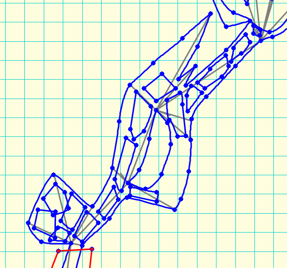
Just an example of real using of Therion - Dave Clucas drawn more than 24 km of new explored passages on Mulu 2009 expedition. The attached file illustrated what was finished at the day of end of expedition. Footleg, I know, I wrote it before, but just try the import to therion from data file exported from PocketTopo. Both to data editor and map editor. Martin
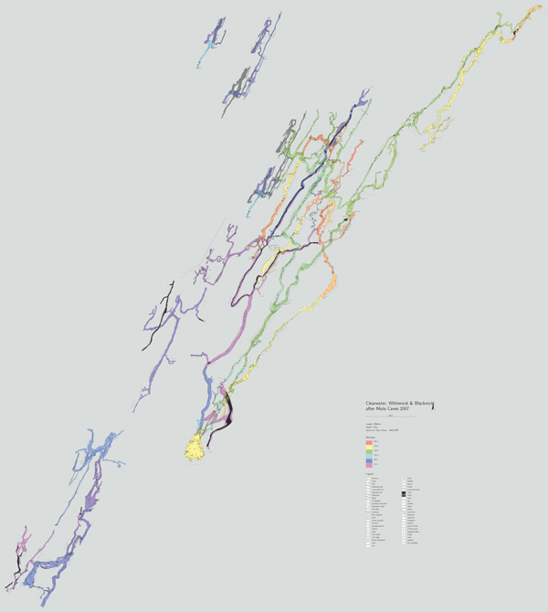
Yes, I realise PocketTopo exports directly to Therion, but we are using Survex to manage the survey data and I am drawing up the finished surveys in Tunnel. If I import to Therion then I am not aware of a method to get my data out again to use in Survex. I did take a look at the Therion export file in a plain text editor, but could not determine the actual survey data from the sketches (I am not an experienced Therion user). Footleg 2009/4/20 Martin Sluka <martinsluka@mac.com>
Footleg, I know, I wrote it before, but just try the import to therion from data file exported from PocketTopo. Both to data editor and map editor.
Martin
_______________________________________________ Therion mailing list Therion@speleo.sk http://mailman.speleo.sk/mailman/listinfo/therion
On 20.4.2009, at 16:51, Footleg wrote:
Therion export file in a plain text editor, but could not determine the actual survey data from the sketches (I am not an experienced Therion user).
Therion export file from PockeTopo is an intermediate format. The data and sketches are generated right in Therion - Import for data and Insert background images -> format PocketTopo for sketches. m.
+++ Martin Sluka [2009-04-20 17:05 +0200]:
On 20.4.2009, at 16:51, Footleg wrote:
Therion export file in a plain text editor, but could not determine the actual survey data from the sketches (I am not an experienced Therion user).
Therion export file from PockeTopo is an intermediate format.
Indeed. Pockettopo puts out threee slightly different text files, none of which is actually in therion or survex format. The one intended for toporobot is closest to one you could use directly in survex. I don't really understand why it outputs something called 'therion export' which is not in therion format. In another message, decribing the process you say: "At base camp, or at home you export data from EasyTopo and import both data and sketches into Therion." Easytopo? Where does that come from - or is that a typo for pockettopo? Therion 5.2.7 comes with a pt2pdf.pl script which does a direct conversion of the 'therion' pockettopo export file into a PDF file containing the data in 3 column format and then the actual rendered plan and elevation, over 4 pages. I guess that's useful as something you could import and draw over, but it seems useless for importing the actual data. It is this script I rewrote to just turn the 'therion export' format file into something which therion could actually understand directly. I get the feeling that I am missing something here... Who writes PocketTopo? Is the code available so we could just make it directly export both survex and therion data? (and so we could port it to Linux perhaps). Wookey -- Principal hats: iEndian - Balloonboard - Toby Churchill - Emdebian http://wookware.org/
On Mon, Apr 20, 2009 at 5:49 PM, Wookey <wookey@wookware.org> wrote:
Therion 5.2.7 comes with a pt2pdf.pl script which does a direct conversion of the 'therion' pockettopo export file into a PDF file containing the data in 3 column format and then the actual rendered plan and elevation, over 4 pages.
I guess that's useful as something you could import and draw over, but it seems useless for importing the actual data. It is this script I rewrote to just turn the 'therion export' format file into something which therion could actually understand directly.
pt2pdf is intended for archivation. It will be included as a tool in xtherion in the future (this is the reason why it is not documented yet). You can already import 'therion export' from PocketTopo directly into latest XTherion: - centerline in text editor - File->Import->PocketTopo therion export - sketches in map editor - Backgroud Images->Insert->PocketTopo therion export
Who writes PocketTopo? Is the code available so we could just make it directly export both survex and therion data? (and so we could port it to Linux perhaps).
Beat Heeb, author of DistoX. Unfortunately it is closed-source, like Auriga. Martin
On 20.4.2009, at 17:49, Wookey wrote:
Easytopo? Where does that come from - or is that a typo for pockettopo?
typo, sorry
Who writes PocketTopo? Is the code available so we could just make it directly export both survex and therion data? (and so we could port it to Linux perhaps).
Beat Heeb himself - paperless.bheeb.ch m.
+++ marco corvi [2009-03-24 12:43 +0100]:
also i have a distoX. i am writing a program to use it with linux. (the programs runs also on windows).
export as therion, of course.
anyone interested to alpha test ? (cannot guarantee, but is should not damage your distox)
Any progress on this Marco (or anyone else?) I have joined the DistoX club too and there is a CSG meet next weekend. I would like to have it talking to my (linux) mobile phone (openmoko). Beat has still not openned the Pocketopo codebase, despite saying he might one day. I am inclined to write a free version rather than wait longer. I'm hoping someone has already done some of this work? Even a really simple app to log the bluetooth data would be a useful start. Wookey -- Principal hats: iEndian - Balloonboard - Toby Churchill - Emdebian http://wookware.org/
participants (10)
-
 Bruce Mutton
-
 Footleg
-
 Guido Verhoeven
-
 marco corvi
-
 Martin Budaj
-
 Martin Luethi
-
 Martin Sluka
-
 Matthias Mansfeld
-
 thierrygonon
-
 Wookey