How to combine two maps

Hello everyone - I am sure someone has come across this problem. I looked all through the Therion Book and the online Wiki, but did not find anything that looked useful. We've been surveying a cave for several years now. It is a tough cave. The map is now a bit over 10,700 feet (3,261 meters). There are several nearby caves that have been getting mapped as time permits. They have been treated as separate projects, each with their own map. Last weekend a human-passable connection was discovered between the big cave and one of the nearby caves. It is only for small humans, but it has been traversed. The centerline survey should be done the next time we go out there. It will only take a few more stations to survey the connection. First question: Is there a way to combine the two maps so that Therion treats them as a single map? I don't want to have to redraw over 300 meters of cave! I suppose I could simply add the th2 files of one cave to the other. Is that the usual method? Second question: We have GPS coordinates of the two entrances. Is it possible to specify both sets in the centerline data? Third question: As I said, there are several smaller caves nearby. It would be useful to have them all displayed on the same printout. Is there a way to tell Therion to import a map and place it on the drawing using GPS coordinates to maintain scale distance? Thanks! -- Bill Gee

Simply create higher survey in which you input all your caves and use it as source for export. This is on of main principles of Therion. Martin S. Odesláno z iPhonu 16. 2. 2018 v 20:19, Bill Gee via Therion <therion@speleo.sk>:
Hello everyone -
I am sure someone has come across this problem. I looked all through the Therion Book and the online Wiki, but did not find anything that looked useful.
We've been surveying a cave for several years now. It is a tough cave. The map is now a bit over 10,700 feet (3,261 meters). There are several nearby caves that have been getting mapped as time permits. They have been treated as separate projects, each with their own map.
Last weekend a human-passable connection was discovered between the big cave and one of the nearby caves. It is only for small humans, but it has been traversed. The centerline survey should be done the next time we go out there. It will only take a few more stations to survey the connection.
First question: Is there a way to combine the two maps so that Therion treats them as a single map? I don't want to have to redraw over 300 meters of cave! I suppose I could simply add the th2 files of one cave to the other. Is that the usual method?
Second question: We have GPS coordinates of the two entrances. Is it possible to specify both sets in the centerline data?
Third question: As I said, there are several smaller caves nearby. It would be useful to have them all displayed on the same printout. Is there a way to tell Therion to import a map and place it on the drawing using GPS coordinates to maintain scale distance?
Thanks!
-- Bill Gee
_______________________________________________ Therion mailing list Therion@speleo.sk https://mailman.speleo.sk/listinfo/therion

Hi Bill, Three times yes. But everything depends on your data/file structure. For every cave I have one top level index file including all surveys and containing maps. When I want to merge related caves I would just create one upper level index th file including index files of relevant caves and define joins using equate commands. For caves without direct connection you can define fix points. \Ladislav 16. 2. 2018 v 20:19, Bill Gee via Therion <therion@speleo.sk>:
Hello everyone -
I am sure someone has come across this problem. I looked all through the Therion Book and the online Wiki, but did not find anything that looked useful.
We've been surveying a cave for several years now. It is a tough cave. The map is now a bit over 10,700 feet (3,261 meters). There are several nearby caves that have been getting mapped as time permits. They have been treated as separate projects, each with their own map.
Last weekend a human-passable connection was discovered between the big cave and one of the nearby caves. It is only for small humans, but it has been traversed. The centerline survey should be done the next time we go out there. It will only take a few more stations to survey the connection.
First question: Is there a way to combine the two maps so that Therion treats them as a single map? I don't want to have to redraw over 300 meters of cave! I suppose I could simply add the th2 files of one cave to the other. Is that the usual method?
Second question: We have GPS coordinates of the two entrances. Is it possible to specify both sets in the centerline data?
Third question: As I said, there are several smaller caves nearby. It would be useful to have them all displayed on the same printout. Is there a way to tell Therion to import a map and place it on the drawing using GPS coordinates to maintain scale distance?
Thanks!
-- Bill Gee
_______________________________________________ Therion mailing list Therion@speleo.sk https://mailman.speleo.sk/listinfo/therion

On 16 February 2018 at 19:19, Bill Gee via Therion <therion@speleo.sk> wrote:
Hello everyone -
I am sure someone has come across this problem. I looked all through the Therion Book and the online Wiki, but did not find anything that looked useful.
We've been surveying a cave for several years now. It is a tough cave. The map is now a bit over 10,700 feet (3,261 meters). There are several nearby caves that have been getting mapped as time permits. They have been treated as separate projects, each with their own map.
Last weekend a human-passable connection was discovered between the big cave and one of the nearby caves. It is only for small humans, but it has been traversed. The centerline survey should be done the next time we go out there. It will only take a few more stations to survey the connection.
First question: Is there a way to combine the two maps so that Therion treats them as a single map? I don't want to have to redraw over 300 meters of cave! I suppose I could simply add the th2 files of one cave to the other. Is that the usual method?
Absolutely no way does it need to be redrawn, or the files moved. in the map defintion of the first cave as add the map of the second cave, maps can be nested and combined in many ways simultaneously
Second question: We have GPS coordinates of the two entrances. Is it possible to specify both sets in the centerline data?
Yes more than one fix (gps) can be used, one gotcha to watch is if no variance is specified on a fixed point they are taken as perfect and not moved in the error distribution. With modern gps and a good signal this is probably becoming close to true on the Northings and Westings, but not always good for height
Third question: As I said, there are several smaller caves nearby. It would be useful to have them all displayed on the same printout. Is there a way to tell Therion to import a map and place it on the drawing using GPS coordinates to maintain scale distance?
Yes I have loads of caves on the same printout in the Cheddar Catchment http://www.cave-registry.org.uk/svn/CheddarCatchment/ Andrew

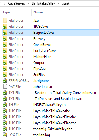
Hi Bill I think you have the answers you need already, but I’ll add my two bits anyway. I do almost the same as Ladislav. Sounds like your caves are or should be part of one Therion project (simply because they are in the same general locality). No need to change anything other than to make sure all of the existing cave folders are collected together in a single project folder (as in the image below). In the example below, my project folder is th_TakakaValley/trunk (the /trunk is just an artefact of the version control system we use) and there are 7 caves. The other folders are for outputs and standardised layout files. I use a flat structure these days, ie each individual cave has its own folder, with INDEX*.th and thconfig files, which is entirely self-contained (except for the output and standard files folders) so an individual cave can be easily moved to any other folder location and still compile with little fuss. Below, the INDEXTakakaValley.thc ties together all of the caves in the project, and puts them on the same map. If two or more of the caves were joined, then I would just create another INDEX file in the top level project folder, eg INDEXBaigentsBreweryCaves.thc, and possibly matching thconfg and layout files. If you download the latest development version of Therion, you can use a lookup to specify particular colours for each of the caves, as described https://therion.speleo.sk/wiki/examples?s[]=lookup#colour_scales_-_lookups <https://therion.speleo.sk/wiki/examples?s%5b%5d=lookup#colour_scales_-_lookups> (half way down the page). Regards Bruce
Hello everyone - Well, that turned out to be easy! I was fearing a huge conglomerated mess of entries in a thconfig and *.th file. It turned out to be some relatively simple mods to thconfig. As noted by several people - I put each cave survey in its own directory. Each directory contains a master .th file and a thconfig file. For bigger projects I create a subdirectory for each survey trip which contains the centerline data and all scanned sketches from that trip. It also contains the .th2 files. One of the centerline data files (usually the first one) contains the GPS coordinates of the cave and also specifies the entrance station. To create the combined map, I created a new survey directory. It contains only a thconfig file. The thconfig file names the three cave surveys like this: # Name the three input caves source ../AllieSpringCaveSurvey/AllieSpringCave.th source ../MillCreekCaveSurvey/MillCreekCave.th source ../ShiftyRockPit/ShiftyRockPit.th The layout sections are exactly the same as in the thconfig files for each cave. The TeX code that I have for changing the size of the legend is also identical, as is the MetaPost code for drawing my custom symbols. At the bottom of the thconfig file I listed the exports. The only thing I changed was the export file names. Everything else is the same as in the thconfig files for each cave. # The main plan map export map -proj plan -layout mainmapnocolor -o CaveRanch.pdf # The main map for printing export map -proj plan -layout mainmapprint -o CaveRanchPrint.pdf (continue for kml, lox and 3d files) When I ran therion with this thconfig file, it Just Worked! The first time! I was astounded. The output files contain all three cave maps and they are properly located relative to each other. WooHoo! That was easy! The next adventure will happen when the link between two of the caves is finally surveyed. The use of an "equate" statement has been mentioned. That needs to go in a .th file - right? Which means, in the end, there will be four .th files mentioned in the thconfig. Is that right? Thanks for all the help and suggestions. -- Bill Gee On Friday, February 16, 2018 10:57:27 PM CST Bruce Mutton via Therion wrote:
Hi Bill
I think you have the answers you need already, but I’ll add my two bits anyway.
I do almost the same as Ladislav.
Sounds like your caves are or should be part of one Therion project (simply because they are in the same general locality). No need to change anything other than to make sure all of the existing cave folders are collected together in a single project folder (as in the image below).
In the example below, my project folder is th_TakakaValley/trunk (the /trunk is just an artefact of the version control system we use) and there are 7 caves.
The other folders are for outputs and standardised layout files.
I use a flat structure these days, ie each individual cave has its own folder, with INDEX*.th and thconfig files, which is entirely self-contained (except for the output and standard files folders) so an individual cave can be easily moved to any other folder location and still compile with little fuss.
Below, the INDEXTakakaValley.thc ties together all of the caves in the project, and puts them on the same map. If two or more of the caves were joined, then I would just create another INDEX file in the top level project folder, eg INDEXBaigentsBreweryCaves.thc, and possibly matching thconfg and layout files.
If you download the latest development version of Therion, you can use a lookup to specify particular colours for each of the caves, as described https://therion.speleo.sk/wiki/examples?s[]=lookup#colour_scales_-_lookups <https://therion.speleo.sk/wiki/examples?s%5b%5d=lookup#colour_scales_-_loo kups> (half way down the page).
Regards
Bruce

Hi Bill, I generally put just one .th file in my thconfig file, and that .th file represents all the caves I want to process with that config. My master .th file then includes the different .th files for different caves, and also contains the equates to link them together (where they are joined by survey data). Footleg On Sun, Feb 18, 2018 at 2:27 PM Bill Gee via Therion <therion@speleo.sk> wrote:
Hello everyone -
Well, that turned out to be easy! I was fearing a huge conglomerated mess of entries in a thconfig and *.th file. It turned out to be some relatively simple mods to thconfig.
As noted by several people - I put each cave survey in its own directory. Each directory contains a master .th file and a thconfig file. For bigger projects I create a subdirectory for each survey trip which contains the centerline data and all scanned sketches from that trip. It also contains the .th2 files.
One of the centerline data files (usually the first one) contains the GPS coordinates of the cave and also specifies the entrance station.
To create the combined map, I created a new survey directory. It contains only a thconfig file. The thconfig file names the three cave surveys like this:
# Name the three input caves
source ../AllieSpringCaveSurvey/AllieSpringCave.th
source ../MillCreekCaveSurvey/MillCreekCave.th
source ../ShiftyRockPit/ShiftyRockPit.th
The layout sections are exactly the same as in the thconfig files for each cave. The TeX code that I have for changing the size of the legend is also identical, as is the MetaPost code for drawing my custom symbols.
At the bottom of the thconfig file I listed the exports. The only thing I changed was the export file names. Everything else is the same as in the thconfig files for each cave.
# The main plan map
export map -proj plan -layout mainmapnocolor -o CaveRanch.pdf
# The main map for printing
export map -proj plan -layout mainmapprint -o CaveRanchPrint.pdf
(continue for kml, lox and 3d files)
When I ran therion with this thconfig file, it Just Worked! The first time! I was astounded. The output files contain all three cave maps and they are properly located relative to each other. WooHoo! That was easy!
The next adventure will happen when the link between two of the caves is finally surveyed. The use of an "equate" statement has been mentioned. That needs to go in a .th file - right? Which means, in the end, there will be four .th files mentioned in the thconfig. Is that right?
Thanks for all the help and suggestions.
--
Bill Gee
On Friday, February 16, 2018 10:57:27 PM CST Bruce Mutton via Therion wrote:
Hi Bill
I think you have the answers you need already, but I’ll add my two bits
anyway.
I do almost the same as Ladislav.
Sounds like your caves are or should be part of one Therion project (simply
because they are in the same general locality). No need to change anything
other than to make sure all of the existing cave folders are collected
together in a single project folder (as in the image below).
In the example below, my project folder is th_TakakaValley/trunk (the
/trunk is just an artefact of the version control system we use) and there
are 7 caves.
The other folders are for outputs and standardised layout files.
I use a flat structure these days, ie each individual cave has its own
folder, with INDEX*.th and thconfig files, which is entirely self-contained
(except for the output and standard files folders) so an individual cave
can be easily moved to any other folder location and still compile with
little fuss.
Below, the INDEXTakakaValley.thc ties together all of the caves in the
project, and puts them on the same map. If two or more of the caves were
joined, then I would just create another INDEX file in the top level
project folder, eg INDEXBaigentsBreweryCaves.thc, and possibly matching
thconfg and layout files.
If you download the latest development version of Therion, you can use a
lookup to specify particular colours for each of the caves, as described
https://therion.speleo.sk/wiki/examples?s[]=lookup#colour_scales_-_lookups
< https://therion.speleo.sk/wiki/examples?s%5b%5d=lookup#colour_scales_-_loo
kups> (half way down the page).
Regards
Bruce
_______________________________________________ Therion mailing list Therion@speleo.sk https://mailman.speleo.sk/listinfo/therion
Bill, if your way works it is OK. But according Therion's philosophy it could be better to create another "higher" "index" .th file which will include all your individual .th files: survey all input ./AllieSpringCaveSurvey/AllieSpringCave.th input ./MillCreekCaveSurvey/MillCreekCave.th input ./ShiftyRockPit/ShiftyRockPit.th map #if necessary ... ... endmap endsurvey Than in thconfig should be source all.th In menu on right side of comparator window you may click on survey or map structure and check, how your data and maps are organised. Martin S. On Feb 18, 2018, at 03:27 PM, Bill Gee via Therion <therion@speleo.sk> wrote: Hello everyone - Well, that turned out to be easy! I was fearing a huge conglomerated mess of entries in a thconfig and *.th file. It turned out to be some relatively simple mods to thconfig. As noted by several people - I put each cave survey in its own directory. Each directory contains a master .th file and a thconfig file. For bigger projects I create a subdirectory for each survey trip which contains the centerline data and all scanned sketches from that trip. It also contains the .th2 files. One of the centerline data files (usually the first one) contains the GPS coordinates of the cave and also specifies the entrance station. To create the combined map, I created a new survey directory. It contains only a thconfig file. The thconfig file names the three cave surveys like this: # Name the three input caves source ../AllieSpringCaveSurvey/AllieSpringCave.th source ../MillCreekCaveSurvey/MillCreekCave.th source ../ShiftyRockPit/ShiftyRockPit.th The layout sections are exactly the same as in the thconfig files for each cave. The TeX code that I have for changing the size of the legend is also identical, as is the MetaPost code for drawing my custom symbols. At the bottom of the thconfig file I listed the exports. The only thing I changed was the export file names. Everything else is the same as in the thconfig files for each cave. # The main plan map export map -proj plan -layout mainmapnocolor -o CaveRanch.pdf # The main map for printing export map -proj plan -layout mainmapprint -o CaveRanchPrint.pdf (continue for kml, lox and 3d files) When I ran therion with this thconfig file, it Just Worked! The first time! I was astounded. The output files contain all three cave maps and they are properly located relative to each other. WooHoo! That was easy! The next adventure will happen when the link between two of the caves is finally surveyed. The use of an "equate" statement has been mentioned. That needs to go in a .th file - right? Which means, in the end, there will be four .th files mentioned in the thconfig. Is that right? Thanks for all the help and suggestions. -- Bill Gee On Friday, February 16, 2018 10:57:27 PM CST Bruce Mutton via Therion wrote:
Hi Bill
I think you have the answers you need already, but I’ll add my two bits anyway.
I do almost the same as Ladislav.
Sounds like your caves are or should be part of one Therion project (simply because they are in the same general locality). No need to change anything other than to make sure all of the existing cave folders are collected together in a single project folder (as in the image below).
In the example below, my project folder is th_TakakaValley/trunk (the /trunk is just an artefact of the version control system we use) and there are 7 caves.
The other folders are for outputs and standardised layout files.
I use a flat structure these days, ie each individual cave has its own folder, with INDEX*.th and thconfig files, which is entirely self-contained (except for the output and standard files folders) so an individual cave can be easily moved to any other folder location and still compile with little fuss.
Below, the INDEXTakakaValley.thc ties together all of the caves in the project, and puts them on the same map. If two or more of the caves were joined, then I would just create another INDEX file in the top level project folder, eg INDEXBaigentsBreweryCaves.thc, and possibly matching thconfg and layout files.
If you download the latest development version of Therion, you can use a lookup to specify particular colours for each of the caves, as described https://therion.speleo.sk/wiki/examples?s[]=lookup#colour_scales_-_lookups <https://therion.speleo.sk/wiki/examples?s%5b%5d=lookup#colour_scales_-_loo kups> (half way down the page).
Regards
Bruce
Therion mailing list Therion@speleo.sk https://mailman.speleo.sk/listinfo/therion
participants (6)
-
 Andrew Atkinson
-
 Bill Gee
-
 Bruce Mutton
-
 Footleg
-
 Ladislav Blažek
-
 Martin Sluka