scrap-drawn maps to small by factor 2

Hallo everybody, I noticed a strange problem drawing a quick survey of a little adit today. This being a little adit I immediately noticed that the scale bar is off by a factor 2, as 20 real meters (in the adit) gave 10 meters in the scale bar. Then I fell back to Therion defaults (no values of mine, no input'ed metapost files etc.), but could not find anything unusual. I noticed then I had the same problem in the survey before, so I wonder. I forced the polygon draw printed besides the scraps-drawn map, then I saw the polygon draw is correct but the acrap-drawn outlines (via th2) are not. So I think I have done some mistake drawing the outlines (curve points followed by 'convert to curve'), but I cannot find anything regarding some scaling I have inadvertly done. As I assume it has something to do with scraps, here the first scrap line from th2: scrap scrap1 -scale [-128.0 -147.685 954.77 -147.685 0.0 0.0 27.502357999999997 0.0 m] Well, can anyone give me a hint? I will gladly give more information, if I just know which:). By the way: I confess I have not read the attachment policy of the list. I risk a little attachment anyway; on may see the scaling mishap in the resulting pdf. Best regards, Christian file.th: -------------------------------------------------------- survey adenauerrank -title "Stollen am Adenauerrank" input stollen_klein_intervall_01.th [some more inputs] equate 0@Stollen_klein_02 25@Stollen_klein_01 [some more equates] input stollen_klein.th2 join scrap2 scrap1 join scrap3 scrap1 map polygon_only.map -projection plan scrap1 scrap2 scrap3 endmap endsurvey map total-map polygon_only.map@stollen_klein # stollen_klein endmap thconfig: ------------------------------------------------------------ source stollen_klein.th select total-map select polygon_only.map@stollen_klein export map -projection plan -o stollen_klein.xvi export map -projection plan -layout-color map-fg 90 -output Stollen_klein.pdf -fmt pdf
Am Montag, 16. Mai 2016, 17:16:31 schrieb Christian Rößler (Roessler): Hallo everybody,
I noticed a strange problem drawing a quick survey of a little adit today. This being a little adit I immediately noticed that the scale bar is off by a factor 2, as 20 real meters (in the adit) gave 10 meters in the scale bar.
well, I cannot find any misconfiguration, and on the other hand I do not think this could be a bug in Therion as other people would have surely noticed such before me. But it drives me nuts, as none of my surveys is of course complete without correct scaling or, in other words, at least a correct scale bar. I think I should give more information to make it easier for others to take a look. I have included a polygon line output in the archive (testmine_polygon_only.pdf) so one may see easily that the polygon draw is correctly scaled. I could not find any information whether the Therion mailing list policy allows attachments, so I prepared two archives containing a Therion project folder for download: http://kartan.de/div/scaling_mishap.zip http://kartan.de/div/scaling_mishap.tar.gz Best regards, Christian
Am Dienstag, 17. Mai 2016, 20:01:12 schrieb Christian Rößler: I am sorry; I forgot: running is a Debian Linux 8.4 (jessie) 64bit, Therion is installed via Debian repository, Therion version is therion 5.3.15-2+b1 amd64. Please let me know if I can supply anything more! Best regards, Christian
Am Dienstag, 17. Mai 2016, 20:01:12 schrieb Christian Rößler: Hallo everybody,
I noticed a strange problem drawing a quick survey of a little adit today. This being a little adit I immediately noticed that the scale bar is off by a factor 2, as 20 real meters (in the adit) gave 10 meters in the scale bar.
well, I cannot find any misconfiguration, and on the other hand I do not think this could be a bug in Therion as other people would have surely noticed such before me.
http://kartan.de/div/scaling_mishap.zip http://kartan.de/div/scaling_mishap.tar.gz
could anyone reproduce this, or even better _not_ reproduce, so I at least know I have done some mistake? By the way: I have tried it on a friend's computer: Newly installed Therion (Debian install); same result. Best regards, Christian

Hi Christian, I had a quick look on your files. First, open you th2 file : you have drawn the walls, but you do not have makes any stations. I think that the mistake comes from that. Maybe I am wrong, but if i have good understood the way Therion is working, for each scrap, you need to plot the stations (using the point "station", and having the option -name 5@testmine_03.testmine for instance). This the way to clip the drawing to the survey. An other comment : in your *.th files, you define both date 2016.05.16 and then declination -2 degrees If I good understood, the « date » option gives the date of the survey, not the date of the drawing (for that, you have to add it in each scrap of the *th2 files). This date is used to correct from the declination. In consequence, you do not have to add the declination -2 degrees after the date option if you have set it well ;-) Cheers, Xavier
Le 26 mai 2016 à 17:08, Christian Rößler <chr_rossi@kartan.de> a écrit :
Am Dienstag, 17. Mai 2016, 20:01:12 schrieb Christian Rößler:
Hallo everybody,
I noticed a strange problem drawing a quick survey of a little adit today. This being a little adit I immediately noticed that the scale bar is off by a factor 2, as 20 real meters (in the adit) gave 10 meters in the scale bar.
well, I cannot find any misconfiguration, and on the other hand I do not think this could be a bug in Therion as other people would have surely noticed such before me.
http://kartan.de/div/scaling_mishap.zip http://kartan.de/div/scaling_mishap.tar.gz
could anyone reproduce this, or even better _not_ reproduce, so I at least know I have done some mistake?
By the way: I have tried it on a friend's computer: Newly installed Therion (Debian install); same result.
Best regards, Christian _______________________________________________ Therion mailing list Therion@speleo.sk http://mailman.speleo.sk/mailman/listinfo/therion

You have to add to each scrap the calibration - either minimum two stations, either manual calibration (scale). Odesláno z iPhonu 28. 5. 2016 v 17:50, Xavier Robert <xavier.robert@ujf-grenoble.fr>:
Hi Christian,
I had a quick look on your files.
First, open you th2 file : you have drawn the walls, but you do not have makes any stations. I think that the mistake comes from that. Maybe I am wrong, but if i have good understood the way Therion is working, for each scrap, you need to plot the stations (using the point "station", and having the option -name 5@testmine_03.testmine for instance). This the way to clip the drawing to the survey.
An other comment : in your *.th files, you define both date 2016.05.16 and then declination -2 degrees If I good understood, the « date » option gives the date of the survey, not the date of the drawing (for that, you have to add it in each scrap of the *th2 files). This date is used to correct from the declination. In consequence, you do not have to add the declination -2 degrees after the date option if you have set it well ;-)
Cheers,
Xavier
Le 26 mai 2016 à 17:08, Christian Rößler <chr_rossi@kartan.de> a écrit :
Am Dienstag, 17. Mai 2016, 20:01:12 schrieb Christian Rößler:
Hallo everybody,
I noticed a strange problem drawing a quick survey of a little adit today. This being a little adit I immediately noticed that the scale bar is off by a factor 2, as 20 real meters (in the adit) gave 10 meters in the scale bar.
well, I cannot find any misconfiguration, and on the other hand I do not think this could be a bug in Therion as other people would have surely noticed such before me.
http://kartan.de/div/scaling_mishap.zip http://kartan.de/div/scaling_mishap.tar.gz
could anyone reproduce this, or even better _not_ reproduce, so I at least know I have done some mistake?
By the way: I have tried it on a friend's computer: Newly installed Therion (Debian install); same result.
Best regards, Christian _______________________________________________ Therion mailing list Therion@speleo.sk http://mailman.speleo.sk/mailman/listinfo/therion
_______________________________________________ Therion mailing list Therion@speleo.sk http://mailman.speleo.sk/mailman/listinfo/therion
Am Samstag, 28. Mai 2016, 10:50:20 schrieb Xavier Robert: Hallo Xavier,
First, open you th2 file : you have drawn the walls, but you do not have makes any stations. I think that the mistake comes from that. Maybe I am wrong, but if i have good understood the way Therion is working, for each scrap, you need to plot the stations (using the point "station", and having the option -name 5@testmine_03.testmine for instance). This the way to clip the drawing to the survey.
many thanks (and to Martin), this is the cause, I think. I had not known about necessary stations at all. I have tried to insert stations, but option | --name 5@testmine_03.testmine yields an error: | therion: error -- testmine.th2 [10] -- survey does not exist -- | testmine_01.testmine -- station does not exist -- 2@testmine_01.testmine If I shorten this to --name 5@testmine_03 it works. I have read in the wiki, that (obviously) two stations are necessary to compute the scale, but if I do that in each scrap, the resulting pdf is heavily distorted, very much so in the free-drawn scrap. I have not found out how to add, as Martin wrote, manual calibration (scale), bit frustrating. Well, an example would take me a long way. Please, can anyone point me to a lrud-survey example with good stations, or, even better, can insert working stations in this testmine survey to see? I promise to write a "miner's beginner guide to Therion with pitfalls" doing the next survey, so others may profit also :).
An other comment : in your *.th files, you define both date 2016.05.16 and then declination -2 degrees If I good understood, the « date » option gives the date of the survey, not the date of the drawing (for that, you have to add it in each scrap of the *th2 files). This date is used to correct from the declination. In consequence, you do not have to add the declination -2 degrees after the date option if you have set it well ;-)
Thanks, will use that, much better! Best regards, Christian PS. If anyone has a litte time for an example, would be most grateful: http://kartan.de/div/scaling_mishap.zip http://kartan.de/div/scaling_mishap.tar.gz
1. 6. 2016 v 14:03, Christian Rößler <chr_rossi@kartan.de>:
| --name 5@testmine_03.testmine
yields an error: | therion: error -- testmine.th2 [10] -- survey does not exist -- | testmine_01.testmine -- station does not exist -- 2@testmine_01.testmine
If I shorten this to --name 5@testmine_03 it works.
Each survey is the namespace. The easiest way how to name stations is, if you input .th2 file in the survey where surveying data are. Then is enough to use only name of station itself - 5 or 2, ...
I have read in the wiki, that (obviously) two stations are necessary to compute the scale, but if I do that in each scrap, the resulting pdf is heavily distorted, very much so in the free-drawn scrap. I have not found out how to add, as Martin wrote, manual calibration (scale), bit frustrating.
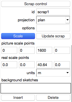
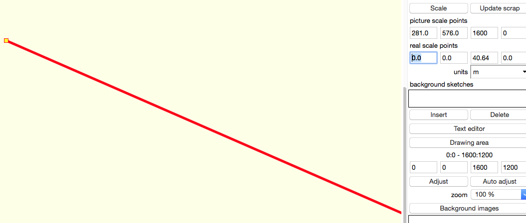
In scrap section of edit window is button Scale. Press it and click on your working canvas on known point - a red rectangle with thick red line should appear. Then click on other known point and there should be second red rectangle and that red line connects both of them. Under button scale are pairs of coordinates - above coordinates measured (in pixels) bellow the correct relative values in meters or inches. m.s. after first click after second click and filling correct coordinates

participants (4)
-
 Christian Rößler
-
Christian Rößler (Roessler)
-
 Martin Sluka
-
 Xavier Robert