
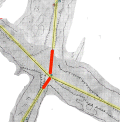
I might understand something wrong, but it seems to me, that what is called `cavelength` in Therion is actually the length of all centerlines. This might correspondent to the cave length in straight caves but certainly not in labyrinth like caves. I was told about the "Kluterthöhle" in germany which was surveyed in the 60ies to ca. 5900 m and then resurveyed and recalculated - to have only a length of 5200 m or so. This is for on the one hand a problem with circular shots inside big rooms, like http://filez.foxel.org/3s3H0d2X361A0K222Z3N An other problem are crossroads like http://filez.foxel.org/1t0C0r2Q011i0g1L0i00 where you can't young the shared area of two passages twice but must - at least to what I have been thought - deduct some part of the centerlines: in the following picture I have marked the parts being considered cavelength yellow and the centerlines not counting as part of the cavelength red https://img.skitch.com/20120221-jhraj625isy8j1i9naxiki3b76.png Certainly I'm not the first person stumbling about this. What is the preferred way to approach the calculation of cave lengths? Regards Maximillian

Interesting questions. In the the main cave I survey, we use a value (called "share") between 0 and 1 for each shot (normally we use 0, 0,5 and 1 and a very few times 0,3 and 0,7). If the the share = 0,5, means that only 50 % of the length is used when we calculate the length of the cave. The total length of the cave is therefore 24439 meters. The length of the centerline is 25703 meters. We calculate the length in Excel, and the depth in Therion. Normally, we do not exclude any length at proper crossroads (share=1,0), meaning that we would have included the red parts in the length of the cave in the crossroad example. Our argument to do so is that a person has to walk that distance if he walks in the center of the passage. (A cave is a 3D-void and, strictly speaking, doesn't have any length, - but we humans would like to think that is has ... :-)) Regards Torstein Den 21.02.2012 21:17, skrev Maximillian Dornseif:
I might understand something wrong, but it seems to me, that what is called `cavelength` in Therion is actually the length of all centerlines.
This might correspondent to the cave length in straight caves but certainly not in labyrinth like caves.
I was told about the "Kluterthöhle" in germany which was surveyed in the 60ies to ca. 5900 m and then resurveyed and recalculated - to have only a length of 5200 m or so.
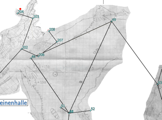
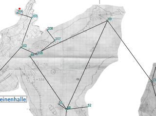
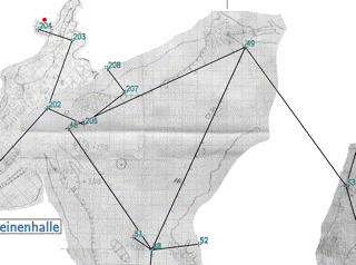
This is for on the one hand a problem with circular shots inside big rooms, like http://filez.foxel.org/3s3H0d2X361A0K222Z3N
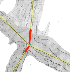
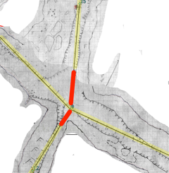
An other problem are crossroads like http://filez.foxel.org/1t0C0r2Q011i0g1L0i00 where you can't young the shared area of two passages twice but must - at least to what I have been thought - deduct some part of the centerlines: in the following picture I have marked the parts being considered cavelength yellow and the centerlines not counting as part of the cavelength red https://img.skitch.com/20120221-jhraj625isy8j1i9naxiki3b76.png
Certainly I'm not the first person stumbling about this.
What is the preferred way to approach the calculation of cave lengths?
Regards
Maximillian
Image 2012.02.21 21:06:44.png20120221-jhraj625isy8j1i9naxiki3b76.png
_______________________________________________ Therion mailing list Therion@speleo.sk http://mailman.speleo.sk/mailman/listinfo/therion

. it seems to me, that what is called `cavelength` in Therion is actually the length of all centerlines.
Yes
This is for on the one hand a problem with circular shots inside big rooms, like http://filez.foxel.org/3s3H0d2X361A0K222Z3N
An other problem are crossroads like http://filez.foxel.org/1t0C0r2Q011i0g1L0i00 where you can't young the shared area of two passages twice but must - at least to what I have been thought - deduct some part of the centerlines: in the following picture I have marked the parts being considered cavelength yellow and the centerlines not counting as part of the cavelength >red https://img.skitch.com/20120221-jhraj625isy8j1i9naxiki3b76.png
I don't get too concerned about this. Like Torstein I figure that if it is similar to a length that you have to walk or crawl along to go from one passage to the next (crossroads), then it is part of the cave length and generally it is close enough to the centerline length as well. Where there are legs that circumambulate big rooms or duplicate passage already surveyed, then I just add 'flags duplicate' (or maybe sometimes 'flags splay'). This removes these legs from Therions centerline cavelength calculation. If one is concerned about precise lengths then one could ensure they place a survey station at each transition between what they deem to be 'duplicate' and 'original' cave passage. Bruce Image 2012.02.21 21:06:44.png20120221-jhraj625isy8j1i9naxiki3b76.png
On 2012-02-21, at 21:17, Maximillian Dornseif wrote:
I might understand something wrong, but it seems to me, that what is called `cavelength` in Therion is actually the length of all centerlines.
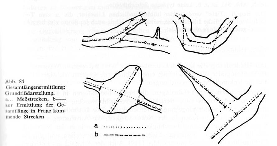
Thanks for the answers I got. To sum up: "don't worry. keep in mind the distance you are traveling when passing 'crossroads' is in both directions so both directions can count for cavelength. My peers in our local caving club where not willing to accept such a Laissez-faire approach. Mind you - we are germans so we like to over specify anything. I was given the canonical german language book on Speleology "Höhlenkunde" (see http://books.google.be/books/about/Höhlenkunde.html?id=CEAJAQAAIAAJ&redir_esc=y#) on page 239f there are 5 paragraphs on "determining the total passage length of a cave". Please forgive my crude translation: The total length of a cave is defined as the sum of all surveyed passages in a cave system. It will be determined by the survey but is not the sum off all centerlines ("Messtrecken") of a survey ("Polygonzug"). If your centerline is running from wall to wall the cave length [has to be based on the center of the passage]. At branches the length of the branching passage is counted from the wall-connection ("Ansatzstelle") and not from the survey station located in the middle of the room. In bigger chambers the longest axis is to be used for calculating the cave length. Small branching passages, which have been documented by crosswise measurement are to be added to the cave length. I have attached the illustration from the page. Has anybody suggestions how to use Therion to calculate the cave length based on this definition? --md
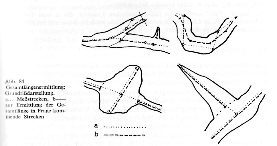
* Has anybody suggestions how to use Therion to calculate the cave length based on this definition? You would have to bear in mind the definition of cave length that you want to adhere to when surveying the cave, and choose stations accordingly. The legs that do not contribute to length would be flagged as duplicate. Alternatively or additionally I think a 'third party' add-on could be written to determine the true passage centerline (not therion's survey centerline) based on the wall lines in the scraps. If the effort is worth the small reduction in length I expect someone will do it. Please not Stacho and Martin though, you have many more important features to work on. Good Luck :) Bruce _____
On 2012-03-04, at 01:22, Bruce wrote:
You would have to bear in mind the definition of cave length that you want to adhere to when surveying the cave, and choose stations accordingly. The legs that do not contribute to length would be flagged as duplicate.
Any suggestion how to integrate that nicely into the data format - be it for therion itself, be it for post processing. Generally what would help a lot is a way to say "of this leg 4.50m long only 3.50m should be added to the cave length. This can be done within Therion today via flags duplicate P144 P147a 252 -2 1.00 flags no duplicate P147a P147 252 -2 3.50 But this seems to be very error prone. An alternative would be to use an external program to determine cave length and just encode the information in the therion file. E.g. flags duplicate P144 P147 252 -2 4.50 # length:3.50 But this would mean not only parsing therion files but also parsing comments. Any suggestions how to incorporate such data with maximum clarity and comparability? I'm unsure it will ever be possible to automatically extract cavelength in complex caves - see attached examples. The "small reduction in length" was about 16% length reduction for the "Kluterthöhle" shown in the second attachment. And to my understanding all organized Austrian & German caving is basing their calculations today on the Trimmel method. Perhaps that is the reason therion sees relative little use (http://therion.speleo.sk/wiki/doku.php?id=projeurope#) in german speaking countries? I'm not complaining. But I would be very grateful for guidance how i can integrate cave length calculation with minimal fuss and thus keeping the data in *.th files in a state where they document our surveys and are not full of hacks which nobody will be able to understand 25 years from now. --md

On 4.3.2012, at 8:46, Maximillian Dornseif wrote:
the definition of cave length
Isn't more simple instead of cave length use the length of surveying legs used to survey a cave? The "length" itself is only for lists of records and reports for sponsors and association administrators. ;o) m.
I wonder whether the cavelength discussed here (or perhaps sum of Passagelength) is, more or less, the same as the sum of the length of the walls divided by two. If yes, I wonder whether it is possible for Therion to calculate the length (3D) of the walls in the scraps/map. Actually, there are several morphometric values that would be very interesting, - if Therion could calculate them. For instance the horisontal passage area of the scraps/map and the volume of the cave. Btw, I could find any attachments. Torstein Den 04.03.2012 08:46, skrev Maximillian Dornseif:
On 2012-03-04, at 01:22, Bruce wrote:
You would have to bear in mind the definition of cave length that you want to adhere to when surveying the cave, and choose stations accordingly. The legs that do not contribute to length would be flagged as duplicate.
Any suggestion how to integrate that nicely into the data format - be it for therion itself, be it for post processing. Generally what would help a lot is a way to say "of this leg 4.50m long only 3.50m should be added to the cave length.
This can be done within Therion today via
flags duplicate P144P147a252-21.00 flags no duplicate P147aP147252-23.50
But this seems to be very error prone. An alternative would be to use an external program to determine cave length and just encode the information in the therion file. E.g.
flags duplicate P144P147252-24.50 # length:3.50
But this would mean not only parsing therion files but also parsing comments. Any suggestions how to incorporate such data with maximum clarity and comparability?
I'm unsure it will ever be possible to automatically extract cavelength in complex caves - see attached examples. The "small reduction in length" was about 16% length reduction for the "Kluterthöhle" shown in the second attachment. And to my understanding all organized Austrian & German caving is basing their calculations today on the Trimmel method. Perhaps that is the reason therion sees relative little use (http://therion.speleo.sk/wiki/doku.php?id=projeurope#) in german speaking countries?
I'm not complaining. But I would be very grateful for guidance how i can integrate cave length calculation with minimal fuss and thus keeping the data in *.th files in a state where they document our surveys and are not full of hacks which nobody will be able to understand 25 years from now.
--md
_______________________________________________ Therion mailing list Therion@speleo.sk http://mailman.speleo.sk/mailman/listinfo/therion
Btw, I could find any attachments.
See http://filez.foxel.org/2v0A2o0o1M2y0K1y3d2P and http://filez.foxel.org/3a3v0g3U0e3X0d3d0M3F (The attachments where TIFF i guess this is stripped by the Mailinglist) --md
On 2012-03-04, at 10:51, Torstein Finnesand wrote:
Actually, there are several morphometric values that would be very interesting, - if Therion could calculate them. For instance the horisontal passage area of the scraps/map and the volume of the cave.
Some of this is calculated by `cavern` (Part of Survex) if you have installed it and Therion is using it. I see the output in therion.log (only when running `therion -d`?): $ cat therion.log ... processing survey data ... ####################### cavern log file ######################## 1> Survex 1.2.5 2> Copyright ? 1990-2012 Olly Betts 3> 4> Survey contains 257 survey stations, joined by 259 legs. 5> There are 3 loops. 6> Total length of survey legs = 630.36m ( 630.12m adjusted) 7> Total plan length of survey legs = 625.40m 8> Total vertical length of survey legs = 42.82m 9> Vertical range = 3.51m (from 169 at 255.68m to 26 at 252.17m) 10> North-South range = 32.41m (from 34 at 1097443.72m to 220 at 1097411.31m) 11> East-West range = 50.22m (from 186 at 5635035.26m to 254 at 5634985.04m) 12> 103 1-nodes. 13> 82 2-nodes. 14> 50 3-nodes. 15> 13 4-nodes. 16> 5 5-nodes. 17> 4 6-nodes. … #################### end of cavern log file #################### … --md
participants (4)
-
 Bruce
-
 Martin Sluka
-
 Maximillian Dornseif
-
 Torstein Finnesand