Depth seems to be including surface legs

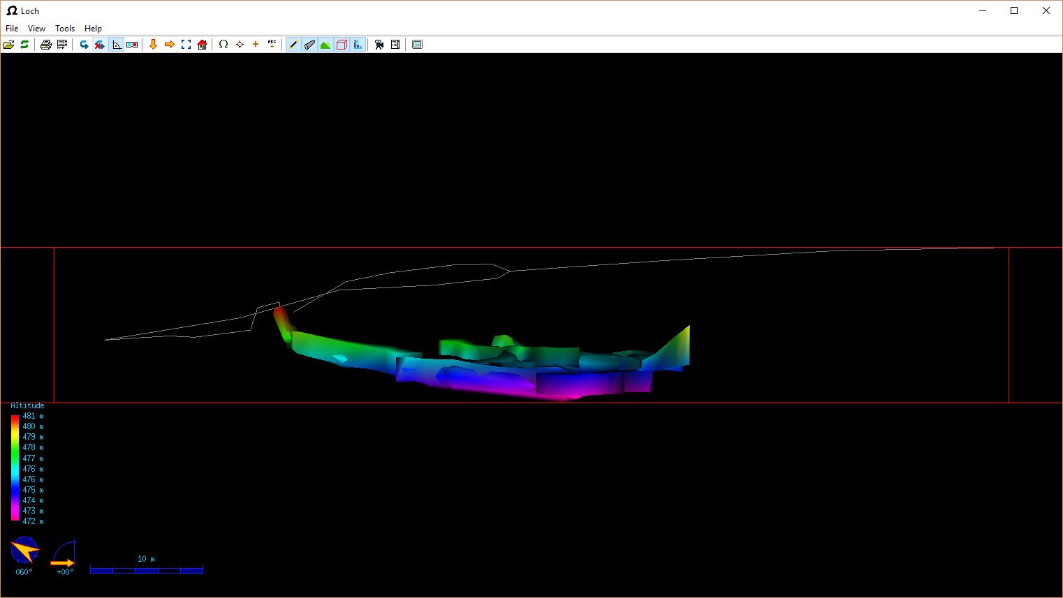
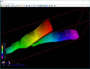
We surveyed the surface above an old mine to get a feel for how thin the roof is. See attached Loch screenshot. Unfortunately, the surface legs are being included in the Depth value displayed on the Plan PDF (see attached). Displayed value is 13m, it should be about 8m. 13m is the maximum vertical extent of all our survey legs. The centerline data for the surface legs has been flagged as "flags surface". These have been correctly omitted from the cave length, and cave length is updated when the surface flag is commented out. However, the vertical range does not alter when the surface flag is toggled. I expected cave depth to be the maximum vertical range of the underground data. Hope someone can set me straight :) Duncan

Is there entrance marked? m.s. On Mar 23, 2017, at 02:04 PM, Duncan via Therion <therion@speleo.sk> wrote: We surveyed the surface above an old mine to get a feel for how thin the roof is. See attached Loch screenshot. Unfortunately, the surface legs are being included in the Depth value displayed on the Plan PDF (see attached). Displayed value is 13m, it should be about 8m. 13m is the maximum vertical extent of all our survey legs. The centerline data for the surface legs has been flagged as "flags surface". These have been correctly omitted from the cave length, and cave length is updated when the surface flag is commented out. However, the vertical range does not alter when the surface flag is toggled. I expected cave depth to be the maximum vertical range of the underground data. Hope someone can set me straight :) Duncan <OldMineLoch.JPG> _______________________________________________ Therion mailing list Therion@speleo.sk https://mailman.speleo.sk/listinfo/therion
Yes the entrance is marked. I've attached the Aven view with entrances highlighted (Therion generated 3D file). Note that the surface legs have been excluded from the Aven presentation. Entrance was declared as follows: cs OSGB:XX fix 21 XXXXX XXXXX 480 # Tweaked to match Google Earth station 21 "Old Mine" entrance Coordinates blanked out at this time. Duncan On 23/03/2017 13:36, Martin Sluka via Therion wrote:
Is there entrance marked?
m.s.
On Mar 23, 2017, at 02:04 PM, Duncan via Therion <therion@speleo.sk> wrote:
We surveyed the surface above an old mine to get a feel for how thin the roof is. See attached Loch screenshot.
Unfortunately, the surface legs are being included in the Depth value displayed on the Plan PDF (see attached). Displayed value is 13m, it should be about 8m. 13m is the maximum vertical extent of all our survey legs.
The centerline data for the surface legs has been flagged as "flags surface". These have been correctly omitted from the cave length, and cave length is updated when the surface flag is commented out. However, the vertical range does not alter when the surface flag is toggled.
I expected cave depth to be the maximum vertical range of the underground data. Hope someone can set me straight :) Duncan
<OldMineLoch.JPG> _______________________________________________ Therion mailing list Therion@speleo.sk <mailto:Therion@speleo.sk> https://mailman.speleo.sk/listinfo/therion
_______________________________________________ Therion mailing list Therion@speleo.sk https://mailman.speleo.sk/listinfo/therion

Hmm, but it looks to me, that scale is only up to altitude 481m, which is altitude of entrance. No surface centerline taken into account. S. On 23 March 2017 at 16:17, Duncan via Therion <therion@speleo.sk> wrote:
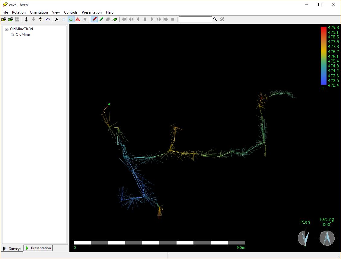
Yes the entrance is marked. I've attached the Aven view with entrances highlighted (Therion generated 3D file). Note that the surface legs have been excluded from the Aven presentation.
Entrance was declared as follows: cs OSGB:XX fix 21 XXXXX XXXXX 480 # Tweaked to match Google Earth station 21 "Old Mine" entrance Coordinates blanked out at this time.
Duncan
On 23/03/2017 13:36, Martin Sluka via Therion wrote:
Is there entrance marked?
m.s.
On Mar 23, 2017, at 02:04 PM, Duncan via Therion <therion@speleo.sk> <therion@speleo.sk> wrote:
We surveyed the surface above an old mine to get a feel for how thin the roof is. See attached Loch screenshot.
Unfortunately, the surface legs are being included in the Depth value displayed on the Plan PDF (see attached). Displayed value is 13m, it should be about 8m. 13m is the maximum vertical extent of all our survey legs.
The centerline data for the surface legs has been flagged as "flags surface". These have been correctly omitted from the cave length, and cave length is updated when the surface flag is commented out. However, the vertical range does not alter when the surface flag is toggled.
I expected cave depth to be the maximum vertical range of the underground data. Hope someone can set me straight :) Duncan
<OldMineLoch.JPG> _______________________________________________ Therion mailing list Therion@speleo.sk https://mailman.speleo.sk/listinfo/therion
_______________________________________________ Therion mailing listTherion@speleo.skhttps://mailman.speleo.sk/listinfo/therion
_______________________________________________ Therion mailing list Therion@speleo.sk https://mailman.speleo.sk/listinfo/therion
Agreed - which makes it all the stranger that the indicated depth on the plan legend is 13m - which includes the surface centerlines. Duncan On 24/03/2017 11:26, Stacho Mudrak via Therion wrote:
Hmm, but it looks to me, that scale is only up to altitude 481m, which is altitude of entrance. No surface centerline taken into account.
S.
On 23 March 2017 at 16:17, Duncan via Therion <therion@speleo.sk <mailto:therion@speleo.sk>> wrote:
Yes the entrance is marked. I've attached the Aven view with entrances highlighted (Therion generated 3D file). Note that the surface legs have been excluded from the Aven presentation.
Entrance was declared as follows: cs OSGB:XX fix 21 XXXXX XXXXX 480 # Tweaked to match Google Earth station 21 "Old Mine" entrance Coordinates blanked out at this time.
Duncan
On 23/03/2017 13:36, Martin Sluka via Therion wrote:
Is there entrance marked?
m.s.
On Mar 23, 2017, at 02:04 PM, Duncan via Therion <therion@speleo.sk> <mailto:therion@speleo.sk> wrote:
We surveyed the surface above an old mine to get a feel for how thin the roof is. See attached Loch screenshot.
Unfortunately, the surface legs are being included in the Depth value displayed on the Plan PDF (see attached). Displayed value is 13m, it should be about 8m. 13m is the maximum vertical extent of all our survey legs.
The centerline data for the surface legs has been flagged as "flags surface". These have been correctly omitted from the cave length, and cave length is updated when the surface flag is commented out. However, the vertical range does not alter when the surface flag is toggled.
I expected cave depth to be the maximum vertical range of the underground data. Hope someone can set me straight :) Duncan
<OldMineLoch.JPG> _______________________________________________ Therion mailing list Therion@speleo.sk <mailto:Therion@speleo.sk> https://mailman.speleo.sk/listinfo/therion <https://mailman.speleo.sk/listinfo/therion>
_______________________________________________ Therion mailing list Therion@speleo.sk <mailto:Therion@speleo.sk> https://mailman.speleo.sk/listinfo/therion <https://mailman.speleo.sk/listinfo/therion>
_______________________________________________ Therion mailing list Therion@speleo.sk <mailto:Therion@speleo.sk> https://mailman.speleo.sk/listinfo/therion <https://mailman.speleo.sk/listinfo/therion>
_______________________________________________ Therion mailing list Therion@speleo.sk https://mailman.speleo.sk/listinfo/therion

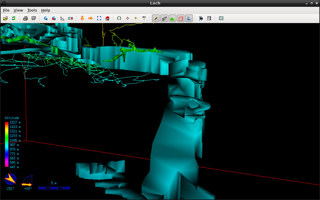
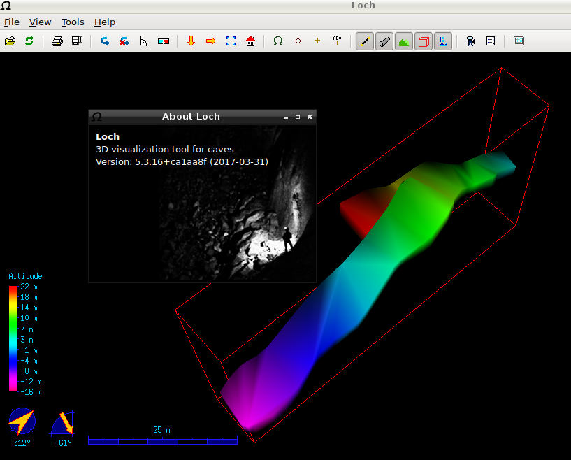
Hello, in my loch model i get some strange artefacts. It seems that the further-away objects are rendered in front of the nearer-in-front objects. I would expect that the passages far away would be covered by those in the front of the camera (as is the case where i did not yet have scraps and only the centerline is present... look at the screenshot) What am i doing wrong?

Possibly your walls are inside out. Do the walls appear and vanish as you rotate the model? That is a sure sign some of your scrap boundaries are not right. Common causes are the insides of loops not flagged as outline in, or walls which cross other walls. Footleg On Fri, Mar 24, 2017 at 3:34 PM Benedikt Hallinger via Therion < therion@speleo.sk> wrote:
Hello, in my loch model i get some strange artefacts.
It seems that the further-away objects are rendered in front of the nearer-in-front objects. I would expect that the passages far away would be covered by those in the front of the camera (as is the case where i did not yet have scraps and only the centerline is present... look at the screenshot)
What am i doing wrong?_______________________________________________ Therion mailing list Therion@speleo.sk https://mailman.speleo.sk/listinfo/therion
Hello, sorry for not responding a while, i tried to debug this myself. Unfortunately i was not able to detect an error in my data. The compile gives no warning at all and also the pdf map output looks like expected. Fortunately i was able to reproduce it in a very simple dataset (with therion 5.3.15 on debian). Please see the attached archive. It does even happen when: - the data is contained in one single centerline only - the break in the map is commented out - no map definition is present at all - all in parallel Is this a bug with loch? With best regards, Beni Am 2017-03-27 10:55, schrieb Footleg:
Possibly your walls are inside out. Do the walls appear and vanish as you rotate the model? That is a sure sign some of your scrap boundaries are not right. Common causes are the insides of loops not flagged as outline in, or walls which cross other walls.
Footleg
On Fri, Mar 24, 2017 at 3:34 PM Benedikt Hallinger via Therion <therion@speleo.sk [3]> wrote:
Hello, in my loch model i get some strange artefacts.
It seems that the further-away objects are rendered in front of the nearer-in-front objects. I would expect that the passages far away would be covered by those in the front of the camera (as is the case where i did not yet have scraps and only the centerline is present... look at the screenshot)
What am i doing wrong?_______________________________________________ Therion mailing list Therion@speleo.sk [1] https://mailman.speleo.sk/listinfo/therion [2]
Links: ------ [1] mailto:Therion@speleo.sk [2] https://mailman.speleo.sk/listinfo/therion [3] mailto:therion@speleo.sk

I'm not seeing any problem with the 2.lox file you supplied, and no problem when compiled with the latest ca1aa8f experimental version of Therion. On windows 10, as perfect a lox file as I’ve ever seen! Maybe it is an Debian 5.3.15 thing? Bruce -----Original Message----- From: Therion [mailto:therion-bounces@speleo.sk] On Behalf Of Benedikt Hallinger via Therion Sent: Saturday, 1 April 2017 9:46 AM To: Footleg <drfootleg@gmail.com> Cc: Benedikt Hallinger <beni@hallinger.org>; List for Therion users <therion@speleo.sk> Subject: Re: [Therion] Loch giving strange artifacts Hello, sorry for not responding a while, i tried to debug this myself. Unfortunately i was not able to detect an error in my data. The compile gives no warning at all and also the pdf map output looks like expected. Fortunately i was able to reproduce it in a very simple dataset (with therion 5.3.15 on debian). Please see the attached archive. It does even happen when: - the data is contained in one single centerline only - the break in the map is commented out - no map definition is present at all - all in parallel Is this a bug with loch? With best regards, Beni Am 2017-03-27 10:55, schrieb Footleg:
Possibly your walls are inside out. Do the walls appear and vanish as
you rotate the model? That is a sure sign some of your scrap
boundaries are not right. Common causes are the insides of loops not
flagged as outline in, or walls which cross other walls.
Footleg
On Fri, Mar 24, 2017 at 3:34 PM Benedikt Hallinger via Therion
< <mailto:therion@speleo.sk%20[3]> therion@speleo.sk [3]> wrote:
Hello,
in my loch model i get some strange artefacts.
It seems that the further-away objects are rendered in front of the
nearer-in-front objects.
I would expect that the passages far away would be covered by those
in the front of the camera (as is the case where i did not yet have
scraps and only the centerline is present... look at the screenshot)
What am i doing wrong?_______________________________________________
Therion mailing list
<mailto:Therion@speleo.sk> Therion@speleo.sk [1]
<https://mailman.speleo.sk/listinfo/therion> https://mailman.speleo.sk/listinfo/therion [2]
Links:
------
[1] <mailto:Therion@speleo.sk> mailto:Therion@speleo.sk
[2] <https://mailman.speleo.sk/listinfo/therion> https://mailman.speleo.sk/listinfo/therion
[3] <mailto:therion@speleo.sk> mailto:therion@speleo.sk
Well... that i interesting. I will try to dig into how to compile therion myself and give it a look! Am 2017-04-01 6:47, schrieb Bruce Mutton via Therion:
I'm not seeing any problem with the 2.lox file you supplied, and no problem when compiled with the latest ca1aa8f experimental version of Therion.
On windows 10, as perfect a lox file as I’ve ever seen!
Maybe it is an Debian 5.3.15 thing?
Bruce
-----Original Message----- From: Therion [mailto:therion-bounces@speleo.sk] On Behalf Of Benedikt Hallinger via Therion Sent: Saturday, 1 April 2017 9:46 AM To: Footleg <drfootleg@gmail.com> Cc: Benedikt Hallinger <beni@hallinger.org>; List for Therion users <therion@speleo.sk> Subject: Re: [Therion] Loch giving strange artifacts
Hello,
sorry for not responding a while, i tried to debug this myself.
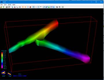
Unfortunately i was not able to detect an error in my data. The compile gives no warning at all and also the pdf map output looks like expected.
Fortunately i was able to reproduce it in a very simple dataset (with therion 5.3.15 on debian).
Please see the attached archive.
It does even happen when:
- the data is contained in one single centerline only
- the break in the map is commented out
- no map definition is present at all
- all in parallel
Is this a bug with loch?
With best regards,
Beni
Am 2017-03-27 10:55, schrieb Footleg:
Possibly your walls are inside out. Do the walls appear and vanish as
you rotate the model? That is a sure sign some of your scrap
boundaries are not right. Common causes are the insides of loops not
flagged as outline in, or walls which cross other walls.
Footleg
On Fri, Mar 24, 2017 at 3:34 PM Benedikt Hallinger via Therion
<therion@speleo.sk [3] [1]> wrote:
Hello,
in my loch model i get some strange artefacts.
It seems that the further-away objects are rendered in front of the
nearer-in-front objects.
I would expect that the passages far away would be covered by those
in the front of the camera (as is the case where i did not yet have
scraps and only the centerline is present... look at the screenshot)
What am i doing wrong?_______________________________________________
Therion mailing list
Therion@speleo.sk [2] [1]
Links:
------
[1] mailto:Therion@speleo.sk [4]
[3] mailto:therion@speleo.sk [6]
Links: ------ [1] mailto:therion@speleo.sk%20[3] [2] mailto:Therion@speleo.sk [3] https://mailman.speleo.sk/listinfo/therion [4] mailto:Therion@speleo.sk [5] https://mailman.speleo.sk/listinfo/therion [6] mailto:therion@speleo.sk
I managed to compile myself[*] but still get the same results. If you don't get such errors i strongly presume that this is a problem either in the underlying libs but i think more probable an issue with my graphics card and/or linux driver. Currently i run the following setup: - Linux phobos 4.9.0-2-686-pae #1 SMP Debian 4.9.13-1 (2017-02-27) i686 GNU/Linux - Debian GNU/Linux 9 (debian stretch / testing) - lxde/openbox on Xorg - Therion from GIT (commit ca1aa8f1b7b4760b9; Fri Mar 31 21:06:03); compiled against VTK 6.3.0 - old Fjitsu-Siemens Amilo Xa2528 - with an GeForce 8600M GS viedo card - running on noveau drivers On my stationary PC i cannot test this as loch hangs up itself (probably an issue with the proprietary nvidia drivers i run there) [*] @wookey: at debian jessie i had some strange dependency problem with some dependant libs of other libs, probably caused by some older mixing of stable/testing; just wanted you to know in case you want to dig into it. I upgraded to debian stretch, where i could install all libs and compile without trouble) Am 2017-03-31 22:46, schrieb Benedikt Hallinger:
Hello, sorry for not responding a while, i tried to debug this myself. Unfortunately i was not able to detect an error in my data. The compile gives no warning at all and also the pdf map output looks like expected.
Fortunately i was able to reproduce it in a very simple dataset (with therion 5.3.15 on debian). Please see the attached archive.
It does even happen when: - the data is contained in one single centerline only - the break in the map is commented out - no map definition is present at all - all in parallel
Is this a bug with loch?
With best regards, Beni
Am 2017-03-27 10:55, schrieb Footleg:
Possibly your walls are inside out. Do the walls appear and vanish as you rotate the model? That is a sure sign some of your scrap boundaries are not right. Common causes are the insides of loops not flagged as outline in, or walls which cross other walls.
Footleg
On Fri, Mar 24, 2017 at 3:34 PM Benedikt Hallinger via Therion <therion@speleo.sk [3]> wrote:
Hello, in my loch model i get some strange artefacts.
It seems that the further-away objects are rendered in front of the nearer-in-front objects. I would expect that the passages far away would be covered by those in the front of the camera (as is the case where i did not yet have scraps and only the centerline is present... look at the screenshot)
What am i doing wrong?_______________________________________________ Therion mailing list Therion@speleo.sk [1] https://mailman.speleo.sk/listinfo/therion [2]
Links: ------ [1] mailto:Therion@speleo.sk [2] https://mailman.speleo.sk/listinfo/therion [3] mailto:therion@speleo.sk
participants (6)
-
 Benedikt Hallinger
-
 Bruce Mutton
-
 Duncan
-
 Footleg
-
 Martin Sluka
-
 Stacho Mudrak