
Further to the posting below, I'm just wondering if there are any updates on the ability to label co-ordinate grids with the northings and eastings at the edge of each sheet (map and or atlas). (I have modified the grids to be displayed as continuous lines.) Bruce From: Martin Budaj <m.b <at> speleo.sk> Subject: Re: labelling the grid <http://news.gmane.org/find-root.php?message_id=%3c20050823062815.M68068%40s peleo.sk%3e> Newsgroups: gmane.comp.gis.therion <http://news.gmane.org/gmane.comp.gis.therion> Date: 2005-08-23 06:33:00 GMT (2 years, 27 weeks, 4 days, 7 hours and 56 minutes ago) On Tue, 23 Aug 2005 00:06:31 +0100, Wookey wrote
Can I make therion put numbers on the edges of the grid to match the co-ordinates used in the dataset?
Unfortunately, not yet. It's somewhere in to-do list. . Martin

With the latest snapshot - it is possible. Just use grid-coords all or grid-coords border in your layout. Not yet docummented feature. Regards, S. Quoting Bruce Mutton <bruce.mutton@paradise.net.nz>:
Further to the posting below, I'm just wondering if there are any updates on the ability to label co-ordinate grids with the northings and eastings at the edge of each sheet (map and or atlas). (I have modified the grids to be displayed as continuous lines.)
Bruce
From: Martin Budaj <m.b <at> speleo.sk> Subject: Re: labelling the grid <http://news.gmane.org/find-root.php?message_id=%3c20050823062815.M68068%40s peleo.sk%3e> Newsgroups: gmane.comp.gis.therion <http://news.gmane.org/gmane.comp.gis.therion> Date: 2005-08-23 06:33:00 GMT (2 years, 27 weeks, 4 days, 7 hours and 56 minutes ago)
On Tue, 23 Aug 2005 00:06:31 +0100, Wookey wrote
Can I make therion put numbers on the edges of the grid to match the co-ordinates used in the dataset?
Unfortunately, not yet. It's somewhere in to-do list. . Martin

Is the latest snapshot only available on linux? The windows version (http://therion.speleo.sk/downloads/therion-update-20080306.exe) does not seem to be accessible:
Forbidden: You don't have permission to access /downloads/therion-update-20080306.exe on this server.
Xavier Stacho Mudrak a écrit :
With the latest snapshot - it is possible. Just use
grid-coords all
or
grid-coords border
in your layout. Not yet docummented feature.
Regards, S.
Quoting Bruce Mutton <bruce.mutton@paradise.net.nz>:
Further to the posting below, I'm just wondering if there are any updates on the ability to label co-ordinate grids with the northings and eastings at the edge of each sheet (map and or atlas). (I have modified the grids to be displayed as continuous lines.)
Bruce
From: Martin Budaj <m.b <at> speleo.sk> Subject: Re: labelling the grid <http://news.gmane.org/find-root.php?message_id=%3c20050823062815.M68068%40s peleo.sk%3e> Newsgroups: gmane.comp.gis.therion <http://news.gmane.org/gmane.comp.gis.therion> Date: 2005-08-23 06:33:00 GMT (2 years, 27 weeks, 4 days, 7 hours and 56 minutes ago)
On Tue, 23 Aug 2005 00:06:31 +0100, Wookey wrote
Can I make therion put numbers on the edges of the grid to match the co-ordinates used in the dataset?
Unfortunately, not yet. It's somewhere in to-do list. . Martin
_______________________________________________ Therion mailing list Therion@speleo.sk http://www.speleo.sk/mailman/listinfo/therion
I am sorry - this file should be accessible now. Thanks for pointing out, S. Quoting Xavier Pennec <Xavier.Pennec@sophia.inria.fr>:
Is the latest snapshot only available on linux? The windows version (http://therion.speleo.sk/downloads/therion-update-20080306.exe) does not seem to be accessible:
Forbidden: You don't have permission to access /downloads/therion-update-20080306.exe on this server.
Xavier
Stacho Mudrak a écrit :
With the latest snapshot - it is possible. Just use
grid-coords all
or
grid-coords border
in your layout. Not yet docummented feature.
Regards, S.
Quoting Bruce Mutton <bruce.mutton@paradise.net.nz>:
Further to the posting below, I'm just wondering if there are any updates on the ability to label co-ordinate grids with the northings and eastings at the edge of each sheet (map and or atlas). (I have modified the grids to be displayed as continuous lines.)
Bruce
From: Martin Budaj <m.b <at> speleo.sk> Subject: Re: labelling the grid
<http://news.gmane.org/find-root.php?message_id=%3c20050823062815.M68068%40s
peleo.sk%3e> Newsgroups: gmane.comp.gis.therion <http://news.gmane.org/gmane.comp.gis.therion> Date: 2005-08-23 06:33:00 GMT (2 years, 27 weeks, 4 days, 7 hours and 56 minutes ago)
On Tue, 23 Aug 2005 00:06:31 +0100, Wookey wrote
Can I make therion put numbers on the edges of the grid to match the co-ordinates used in the dataset?
Unfortunately, not yet. It's somewhere in to-do list. . Martin
_______________________________________________ Therion mailing list Therion@speleo.sk http://www.speleo.sk/mailman/listinfo/therion
...but before you go caving Stacho, The following code; grid-coords all works very nicely, but the next seems to produce no output grid-coords border Could it be that the border co-ordinates are hidden on my exported maps because of some other setting? Bruce -----Original Message----- From: therion-bounces@speleo.sk [mailto:therion-bounces@speleo.sk] On Behalf Of Stacho Mudrak Sent: Friday, 7 March 2008 3:39 a.m. To: therion@speleo.sk Subject: Re: [Therion] labelling grids With the latest snapshot - it is possible. Just use grid-coords all or grid-coords border in your layout. Not yet docummented feature. Regards, S. Quoting Bruce Mutton <bruce.mutton@paradise.net.nz>:
Further to the posting below, I'm just wondering if there are any updates on the ability to label co-ordinate grids with the northings and eastings at the edge of each sheet (map and or atlas). (I have modified the grids to be displayed as continuous lines.)
Bruce
From: Martin Budaj <m.b <at> speleo.sk> Subject: Re: labelling the grid
<http://news.gmane.org/find-root.php?message_id=%3c20050823062815.M68068%40s
peleo.sk%3e> Newsgroups: gmane.comp.gis.therion <http://news.gmane.org/gmane.comp.gis.therion> Date: 2005-08-23 06:33:00 GMT (2 years, 27 weeks, 4 days, 7 hours and 56 minutes ago)
On Tue, 23 Aug 2005 00:06:31 +0100, Wookey wrote
Can I make therion put numbers on the edges of the grid to match the co-ordinates used in the dataset?
Unfortunately, not yet. It's somewhere in to-do list. . Martin
_______________________________________________ Therion mailing list Therion@speleo.sk http://www.speleo.sk/mailman/listinfo/therion
This is probably because your grid border is behind paper margin. Try to set bigger layout overlap. Regards, S. On Thu, Apr 17, 2008 at 12:04 AM, Bruce Mutton <bruce.mutton@paradise.net.nz> wrote:
...but before you go caving Stacho, The following code; grid-coords all
works very nicely, but the next seems to produce no output grid-coords border
Could it be that the border co-ordinates are hidden on my exported maps because of some other setting?
Bruce
-----Original Message----- From: therion-bounces@speleo.sk [mailto:therion-bounces@speleo.sk] On Behalf Of Stacho Mudrak Sent: Friday, 7 March 2008 3:39 a.m. To: therion@speleo.sk Subject: Re: [Therion] labelling grids
With the latest snapshot - it is possible. Just use
grid-coords all
or
grid-coords border
in your layout. Not yet docummented feature.
Regards, S.
Quoting Bruce Mutton <bruce.mutton@paradise.net.nz>:
Further to the posting below, I'm just wondering if there are any updates on the ability to label co-ordinate grids with the northings and eastings at the edge of each sheet (map and or atlas). (I have modified the grids to be displayed as continuous lines.)
Bruce
From: Martin Budaj <m.b <at> speleo.sk> Subject: Re: labelling the grid
<http://news.gmane.org/find-root.php?message_id=%3c20050823062815.M68068%40s
peleo.sk%3e> Newsgroups: gmane.comp.gis.therion <http://news.gmane.org/gmane.comp.gis.therion> Date: 2005-08-23 06:33:00 GMT (2 years, 27 weeks, 4 days, 7 hours and 56 minutes ago)
On Tue, 23 Aug 2005 00:06:31 +0100, Wookey wrote
Can I make therion put numbers on the edges of the grid to match the co-ordinates used in the dataset?
Unfortunately, not yet. It's somewhere in to-do list. . Martin
_______________________________________________ Therion mailing list Therion@speleo.sk http://www.speleo.sk/mailman/listinfo/therion
_______________________________________________ Therion mailing list Therion@speleo.sk http://www.speleo.sk/mailman/listinfo/therion
grid-coords border Have had quite a play with "grid-coords border", and they work well on projections, but not so well with plan views. With my grids 100mm apart (100m @ 1:1000) I have to have quite large overlap values (typically 6 - 9 cm) to encompass the outermost grids. This I can live with I guess, but it can mean that my map will not fit on a standard paper roll width. If the 'rotate' value is other than 000 (north up page) then only the values are displayed where the grid outline falls within the page. I wonder if the behaviour could be changed so that the co-ords are plotted along the PAGE outline rather than along the GRID outline. This way they would be plotted regardless of the overlap and rotate values. Also, perhaps rather than plotting co-ordinate pairs on the east-west grids, maybe plotting the eastings on the north-south grids and the northings on the east-west grids would be more intuitive for users of the map. labels And researching this, I noticed that not only do the text labels not survive changes of output scale very well, but changes of output map 'rotate' value really screws them up. Ultimately I'd like to print the components of the cave system I'm working on in at least two orientations. I realise that this presents some conceptual layout problems that the user will always have to deal with, regardless of whether software or paper is the drawing medium, but perhaps Therion could ultimately be made to help out? Perhaps all point labels without 'orientation' could be given a default orientation within the layout definition. (Maybe this exists already?) At the moment I think the default is, orientate text to be read from the 'bottom' of the page (directly linked to the 'rotate' variable I think) What if there was another alternative, say, make the label orientation relative to the map grid? There could be a label-flip [on/off] to make labels flip up the correct way if they happen to be plotted upside down. For now I guess I could use point labels with orientation, or line labels to achieve similar results. Enough! My brain is beginning to hurt. Bruce From: therion-bounces@speleo.sk [mailto:therion-bounces@speleo.sk] On Behalf Of Stacho Mudrak Sent: Thursday, 17 April 2008 8:28 p.m. This is probably because your grid border is behind paper margin. Try to set bigger layout overlap. Regards, S. On Thu, Apr 17, 2008 at 12:04 AM, Bruce Mutton <bruce.mutton@paradise.net.nz> wrote:
...but before you go caving Stacho, The following code; grid-coords all
works very nicely, but the next seems to produce no output grid-coords border
Could it be that the border co-ordinates are hidden on my exported maps because of some other setting?
Bruce
I wonder if the behaviour could be changed so that the co-ords are plotted along the PAGE outline rather than along the GRID outline. This way they would be plotted regardless of the overlap and rotate values.
It is not yet possible - but we will add it to the TODO list. Labeling grid with coordinates is currently quite preliminary feature. User has very limited control over it. This functionality needs to be enhanced a lot including adding more user control and also showing grid coordinates in the atlas page border also.
And researching this, I noticed that not only do the text labels not survive changes of output scale very well, but changes of output map 'rotate' value really screws them up. Ultimately I'd like to print the components of the cave system I'm working on in at least two orientations. I realise that this presents some conceptual layout problems that the user will always have to deal with, regardless of whether software or paper is the drawing medium, but perhaps Therion could ultimately be made to help out?
Labeling is another issue - that needs a lot of work :( You are completely right.
Perhaps all point labels without 'orientation' could be given a default orientation within the layout definition. (Maybe this exists already?) At the moment I think the default is, orientate text to be read from the 'bottom' of the page (directly linked to the 'rotate' variable I think) What if there was another alternative, say, make the label orientation relative to the map grid? There could be a label-flip [on/off] to make labels flip up the correct way if they happen to be plotted upside down.
OK, I think at least it should not be very complicated to add some switch to the layout, that will define default text orientation for labels without it. It looks to me like a good idea - I will add it into TODO list. Regards, S.

On Tue, Apr 22, 2008 at 9:36 AM, Stacho Mudrak <s.m@group-s.sk> wrote:
I wonder if the behaviour could be changed so that the co-ords are plotted along the PAGE outline rather than along the GRID outline. This way they would be plotted regardless of the overlap and rotate values.
It is not yet possible - but we will add it to the TODO list.
Labeling grid with coordinates is currently quite preliminary feature. User has very limited control over it. This functionality needs to be enhanced a lot including adding more user control and also showing grid coordinates in the atlas page border also.
Printing coordinates along the border is straightforward if the grid is plotted using continuous lines and not too much rotated, like parallels and meridians in the school atlas. But there are problems if the grid is plotted using small crosses (default in therion) -- how the intersection of grid and page border should be indicated if no cross lies accidentaly just on the border? Should some additional cross or line be added?
Also, perhaps rather than plotting co-ordinate pairs on the east-west grids, maybe plotting the eastings on the north-south grids and the northings on the east-west grids would be more intuitive for users of the map.
What to do if the grid is substantially rotated, e.g. by 45 or 135 degrees? You would not be able to distinguish which coordiante belongs to which grid line (see below ascii illustration of grid rotated by 45 degrees). | 10< | |____V_____V____ 100 200 Martin
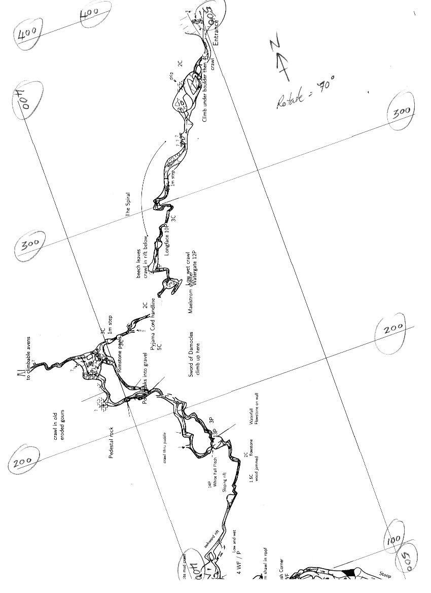
Martin Yes, crosses are perhaps a problem, but perhaps the labelling routine is completely separate from the grid cross/line routine, so maybe the matter is aesthetic only, not programmatic. I attach a scan of a grid rotated 70 deg and labelled by hand in the manner I envisage -oriented parallel to the appropriate grid, and just inside the edge of the page. Bruce -----Original Message----- From: therion-bounces@speleo.sk [mailto:therion-bounces@speleo.sk] On Behalf Of Martin Budaj Sent: Tuesday, 22 April 2008 8:29 p.m. To: therion@speleo.sk Subject: Re: [Therion] labelling grids (and label orientation) ... Printing coordinates along the border is straightforward if the grid is plotted using continuous lines and not too much rotated, like parallels and meridians in the school atlas. But there are problems if the grid is plotted using small crosses (default in therion) -- how the intersection of grid and page border should be indicated if no cross lies accidentaly just on the border? Should some additional cross or line be added?
Also, perhaps rather than plotting co-ordinate pairs on the east-west grids, maybe plotting the eastings on the north-south grids and the northings on the east-west grids would be more intuitive for users of the map.
What to do if the grid is substantially rotated, e.g. by 45 or 135 degrees? You would not be able to distinguish which coordiante belongs to which grid line (see below ascii illustration of grid rotated by 45 degrees). | 10< | |____V_____V____ 100 200 Martin
participants (4)
-
 Bruce Mutton
-
 Martin Budaj
-
 Stacho Mudrak
-
 Xavier Pennec