Re: [Therion] Scrap is too large to process in metapost in this scale

It seems it will work if I add station points with the .xvi layer activated as background image. Initally I disabled the layer because of the grid, which I found quite annoying, and I kept only the morphed images. It seems that in this way the program didn't recorded well the coordinates of the points. Otherwise, with the .xvi grid and centerline visible, if I add a station point it recognizes its name automatically, and the coordinates are a little bit different, with lot of decimals. For the moment it compiles fine, in both .pdf and .shp format. Cheers, Mihai T. On Wed, Nov 23, 2011 at 11:06 AM, Mihai Terente <terenteml@gmail.com> wrote:
Yes, the same problem occurs when I add several station points. But this happens only when I reeference the points to stations from the survey (witn -name ...). I think it's something related to my approach for morphing scanned images. I did like this: - first I started an empty .th2 file (named schita-c1_w.th2, _w stands for "warped") - I added a background image (a piece of the scanned sketch, CC01.jpeg), with Edit>Insert Image - I created a scrap and I selected the scketch as a background image, with the Insert button from the Scraps section in the control panel - I added several station points, referenced to the station from a survey, with -name ...@survey. From these stations it's only one that is georeferenced (with fix command, in the survey preamble) - then I compiled the map with -format .xvi - Now, I noticed that if I add the .xvi file to my first .th2 file, I get the image morphed, with the centerline on top of it, but displaced with respect to my initial station points added to the scrap. - That's why I a created a new .th2 file (schita_c1.th2), I added the .xvi file as a background image and I drew the wall. If I compile the map now (output esri .shp) everything goes fine, except that the .shp is not georeferenced. If I add to the scrap the station point that is georeferenced (fix) in the survey I get the error.
I put everything into the archive attached, if you have time to take a look, I would appreciate.
Mihai T.
I put all my files in the .zip attached
On Wed, Nov 23, 2011 at 10:42 AM, Xavier Pennec <Xavier.Pennec@inria.fr> wrote:
The problem could be that you have only one station point. Could you try to add a second one so that therion can scale the scrap consistently?
Xavier
Le 23/11/2011 07:19, Mihai Terente a écrit :
Dear friends,
I encountered the same problem and I was wondering if someone can figure a solution. I work with a morphed image on the background and the project compiles well with the scraps containing only walls. But if I add to the scrap a station point referenced to a survey (e.g. -name 2400@survey) I get the error. Any suggestion?
Mihai T.
Footleg drfootleg at gmail.com Wed Mar 9 18:29:08 CET 2011
My files illustrating the problem are my entire project at this stage!
There are 2 .th2 files in there. The smaller one is the single scrap which works. The larger one is several scraps where only one is used in the map, and causes the error.
Attached in zip. It is not very large so sending to the list.
Footleg
On 9 March 2011 15:33, Martin Budaj<m.budaj at gmail.com> wrote:
On Wed, Mar 9, 2011 at 3:58 PM, Footleg<drfootleg at gmail.com> wrote:
Yes, I put in three stations, which are named to match stations in a
survex
3d file which is imported. Exactly the same scrap in a th2 file on it's own works fine. But when the other scraps which I am not yet using in the map are in the th2 file it fails with the errors given.
I can email you the complete project files if you need them.
Sure. Stripped files still producing this message would be better than the complete project.
Martin _______________________________________________ Therion mailing list Therion at speleo.sk http://mailman.speleo.sk/mailman/listinfo/therion
_______________________________________________ Therion mailing list Therion@speleo.sk http://mailman.speleo.sk/mailman/listinfo/therion
--
------------------------- Xavier Pennec Senior Research Scientist / Directeur de recherche Asclepios project-team, INRIA Sophia-Antipolis 2004 Route des Lucioles, BP93 F-06902 Sophia-Antipolis Cedex, France +33 4 92 38 76 64 +33 6 78 35 16 90 http://www-sop.inria.fr/asclepios/ -------------------------------
_______________________________________________ Therion mailing list Therion@speleo.sk http://mailman.speleo.sk/mailman/listinfo/therion

Hello Mihai I am intrigued that you are using both scanned images and xvi files in the same drawing file (as mentioned in your 23Nov message below). My friend and I were just discussing this and my assumption was that it would be an uncomfortable match if both types of image were used in the same scrap because we cannot scale or rotate background images within the XTherion interface (with respect to each other).
From your description below you seem to be using quite a different drawing strategy (in some respects) to what we use. If you are willing to share your dataset with the forum (if not too big) or by personal message, I would appreciate the learning. Thanks Bruce
-----Original Message----- From: therion-bounces@speleo.sk [mailto:therion-bounces@speleo.sk] On Behalf Of Mihai Terente Sent: Thursday, 24 November 2011 3:26 a.m. To: List for Therion users Subject: Re: [Therion] Scrap is too large to process in metapost in thisscale It seems it will work if I add station points with the .xvi layer activated as background image. Initally I disabled the layer because of the grid, which I found quite annoying, and I kept only the morphed images. It seems that in this way the program didn't recorded well the coordinates of the points. Otherwise, with the .xvi grid and centerline visible, if I add a station point it recognizes its name automatically, and the coordinates are a little bit different, with lot of decimals. For the moment it compiles fine, in both .pdf and .shp format. Cheers, Mihai T. On Wed, Nov 23, 2011 at 11:06 AM, Mihai Terente <terenteml@gmail.com> wrote:
Yes, the same problem occurs when I add several station points. But this happens only when I reeference the points to stations from the survey (witn -name ...). I think it's something related to my approach for morphing scanned images. I did like this: - first I started an empty .th2 file (named schita-c1_w.th2, _w stands for "warped") - I added a background image (a piece of the scanned sketch, CC01.jpeg), with Edit>Insert Image - I created a scrap and I selected the scketch as a background image, with the Insert button from the Scraps section in the control panel - I added several station points, referenced to the station from a survey, with -name ...@survey. From these stations it's only one that is georeferenced (with fix command, in the survey preamble) - then I compiled the map with -format .xvi - Now, I noticed that if I add the .xvi file to my first .th2 file, I get the image morphed, with the centerline on top of it, but displaced with respect to my initial station points added to the scrap. - That's why I a created a new .th2 file (schita_c1.th2), I added the .xvi file as a background image and I drew the wall. If I compile the map now (output esri .shp) everything goes fine, except that the .shp is not georeferenced. If I add to the scrap the station point that is georeferenced (fix) in the survey I get the error.
I put everything into the archive attached, if you have time to take a look, I would appreciate.
Mihai T.
I put all my files in the .zip attached

Dear Mihai, thanks for the data. It looks you have found a problem in therion. The problem is simple. In the scrap scrap-c1, there is no station. Therefore it calculates coordinates according to calibration - assuming calibration is in the output coordinate system. Obviosly, this is not your case. Therefore adding just single station to every scrap places this scrap correctly and it starts working. In this case, therion should generate an error, that would be easy to understand. Thanks for pointing this out. Best regards, S. On 23 November 2011 20:14, Bruce <bruce@tomo.co.nz> wrote:
Hello Mihai I am intrigued that you are using both scanned images and xvi files in the same drawing file (as mentioned in your 23Nov message below). My friend and I were just discussing this and my assumption was that it would be an uncomfortable match if both types of image were used in the same scrap because we cannot scale or rotate background images within the XTherion interface (with respect to each other).
From your description below you seem to be using quite a different drawing strategy (in some respects) to what we use. If you are willing to share your dataset with the forum (if not too big) or by personal message, I would appreciate the learning. Thanks Bruce
-----Original Message----- From: therion-bounces@speleo.sk [mailto:therion-bounces@speleo.sk] On Behalf Of Mihai Terente Sent: Thursday, 24 November 2011 3:26 a.m. To: List for Therion users Subject: Re: [Therion] Scrap is too large to process in metapost in thisscale
It seems it will work if I add station points with the .xvi layer activated as background image. Initally I disabled the layer because of the grid, which I found quite annoying, and I kept only the morphed images. It seems that in this way the program didn't recorded well the coordinates of the points. Otherwise, with the .xvi grid and centerline visible, if I add a station point it recognizes its name automatically, and the coordinates are a little bit different, with lot of decimals.
For the moment it compiles fine, in both .pdf and .shp format.
Cheers, Mihai T.
On Wed, Nov 23, 2011 at 11:06 AM, Mihai Terente <terenteml@gmail.com> wrote:
Yes, the same problem occurs when I add several station points. But this happens only when I reeference the points to stations from the survey (witn -name ...). I think it's something related to my approach for morphing scanned images. I did like this: - first I started an empty .th2 file (named schita-c1_w.th2, _w stands for "warped") - I added a background image (a piece of the scanned sketch, CC01.jpeg), with Edit>Insert Image - I created a scrap and I selected the scketch as a background image, with the Insert button from the Scraps section in the control panel - I added several station points, referenced to the station from a survey, with -name ...@survey. From these stations it's only one that is georeferenced (with fix command, in the survey preamble) - then I compiled the map with -format .xvi - Now, I noticed that if I add the .xvi file to my first .th2 file, I get the image morphed, with the centerline on top of it, but displaced with respect to my initial station points added to the scrap. - That's why I a created a new .th2 file (schita_c1.th2), I added the .xvi file as a background image and I drew the wall. If I compile the map now (output esri .shp) everything goes fine, except that the .shp is not georeferenced. If I add to the scrap the station point that is georeferenced (fix) in the survey I get the error.
I put everything into the archive attached, if you have time to take a look, I would appreciate.
Mihai T.
I put all my files in the .zip attached
_______________________________________________ Therion mailing list Therion@speleo.sk http://mailman.speleo.sk/mailman/listinfo/therion
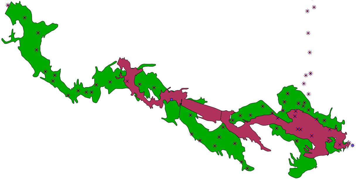
Dear Stacho, Indeed, if I place a station in every scrap it will place the whole map correctly. But it seems that it's not enough, the shape of the cave is not well rendered. I need to place all the station points so that the output shape to be correctly displayed. See the attached image, where I have the same cave passage. With dark green it's the shape of the cave after I put all the station points, while with dark red it's the shape with only two station points, the yellow dots. Anyway, many thanks, the problem is solved! Mihai On Wed, Nov 23, 2011 at 10:34 PM, Stacho Mudrak <lists@group-s.sk> wrote:
Dear Mihai, thanks for the data. It looks you have found a problem in therion. The problem is simple. In the scrap scrap-c1, there is no station. Therefore it calculates coordinates according to calibration - assuming calibration is in the output coordinate system. Obviosly, this is not your case. Therefore adding just single station to every scrap places this scrap correctly and it starts working. In this case, therion should generate an error, that would be easy to understand. Thanks for pointing this out. Best regards, S. On 23 November 2011 20:14, Bruce <bruce@tomo.co.nz> wrote:
Hello Mihai I am intrigued that you are using both scanned images and xvi files in the same drawing file (as mentioned in your 23Nov message below). My friend and I were just discussing this and my assumption was that it would be an uncomfortable match if both types of image were used in the same scrap because we cannot scale or rotate background images within the XTherion interface (with respect to each other).
From your description below you seem to be using quite a different drawing strategy (in some respects) to what we use. If you are willing to share your dataset with the forum (if not too big) or by personal message, I would appreciate the learning. Thanks Bruce
-----Original Message----- From: therion-bounces@speleo.sk [mailto:therion-bounces@speleo.sk] On Behalf Of Mihai Terente Sent: Thursday, 24 November 2011 3:26 a.m. To: List for Therion users Subject: Re: [Therion] Scrap is too large to process in metapost in thisscale
It seems it will work if I add station points with the .xvi layer activated as background image. Initally I disabled the layer because of the grid, which I found quite annoying, and I kept only the morphed images. It seems that in this way the program didn't recorded well the coordinates of the points. Otherwise, with the .xvi grid and centerline visible, if I add a station point it recognizes its name automatically, and the coordinates are a little bit different, with lot of decimals.
For the moment it compiles fine, in both .pdf and .shp format.
Cheers, Mihai T.
On Wed, Nov 23, 2011 at 11:06 AM, Mihai Terente <terenteml@gmail.com> wrote:
Yes, the same problem occurs when I add several station points. But this happens only when I reeference the points to stations from the survey (witn -name ...). I think it's something related to my approach for morphing scanned images. I did like this: - first I started an empty .th2 file (named schita-c1_w.th2, _w stands for "warped") - I added a background image (a piece of the scanned sketch, CC01.jpeg), with Edit>Insert Image - I created a scrap and I selected the scketch as a background image, with the Insert button from the Scraps section in the control panel - I added several station points, referenced to the station from a survey, with -name ...@survey. From these stations it's only one that is georeferenced (with fix command, in the survey preamble) - then I compiled the map with -format .xvi - Now, I noticed that if I add the .xvi file to my first .th2 file, I get the image morphed, with the centerline on top of it, but displaced with respect to my initial station points added to the scrap. - That's why I a created a new .th2 file (schita_c1.th2), I added the .xvi file as a background image and I drew the wall. If I compile the map now (output esri .shp) everything goes fine, except that the .shp is not georeferenced. If I add to the scrap the station point that is georeferenced (fix) in the survey I get the error.
I put everything into the archive attached, if you have time to take a look, I would appreciate.
Mihai T.
I put all my files in the .zip attached
_______________________________________________ Therion mailing list Therion@speleo.sk http://mailman.speleo.sk/mailman/listinfo/therion
_______________________________________________ Therion mailing list Therion@speleo.sk http://mailman.speleo.sk/mailman/listinfo/therion
Dear Bruce, I'm using the .xvi compiled with the option -layout-sketches on. This way, the .xvi file is not a simple vector drawing, with only the centerline, but a more complex one, with also the scanned images (which is a raster data) morphed to match the centerline (the vector data). Indeed I cannot scale or rotate any of the two components of the .xvi file (the vector, with the centerline, and the raster, with the scanned images) inside Xtherion. But I keep separate scrap file, one for morphing the scanned image, and one for drawing over the morphed image. This way I can modify anytime the first scrap, e.g. by adding more station points to get a better morphed image, I recompile and I get an .xvi which will be updated in every scrap that I'm using to draw the cave. I sent an archive with my data to the list on a previous message. You can look at and compile first the thconfig_xvi, than thconfig_pdf. Mihai www.iser.ro On Wed, Nov 23, 2011 at 9:14 PM, Bruce <bruce@tomo.co.nz> wrote:
Hello Mihai I am intrigued that you are using both scanned images and xvi files in the same drawing file (as mentioned in your 23Nov message below). My friend and I were just discussing this and my assumption was that it would be an uncomfortable match if both types of image were used in the same scrap because we cannot scale or rotate background images within the XTherion interface (with respect to each other).
From your description below you seem to be using quite a different drawing strategy (in some respects) to what we use. If you are willing to share your dataset with the forum (if not too big) or by personal message, I would appreciate the learning. Thanks Bruce
-----Original Message----- From: therion-bounces@speleo.sk [mailto:therion-bounces@speleo.sk] On Behalf Of Mihai Terente Sent: Thursday, 24 November 2011 3:26 a.m. To: List for Therion users Subject: Re: [Therion] Scrap is too large to process in metapost in thisscale
It seems it will work if I add station points with the .xvi layer activated as background image. Initally I disabled the layer because of the grid, which I found quite annoying, and I kept only the morphed images. It seems that in this way the program didn't recorded well the coordinates of the points. Otherwise, with the .xvi grid and centerline visible, if I add a station point it recognizes its name automatically, and the coordinates are a little bit different, with lot of decimals.
For the moment it compiles fine, in both .pdf and .shp format.
Cheers, Mihai T.
On Wed, Nov 23, 2011 at 11:06 AM, Mihai Terente <terenteml@gmail.com> wrote:
Yes, the same problem occurs when I add several station points. But this happens only when I reeference the points to stations from the survey (witn -name ...). I think it's something related to my approach for morphing scanned images. I did like this: - first I started an empty .th2 file (named schita-c1_w.th2, _w stands for "warped") - I added a background image (a piece of the scanned sketch, CC01.jpeg), with Edit>Insert Image - I created a scrap and I selected the scketch as a background image, with the Insert button from the Scraps section in the control panel - I added several station points, referenced to the station from a survey, with -name ...@survey. From these stations it's only one that is georeferenced (with fix command, in the survey preamble) - then I compiled the map with -format .xvi - Now, I noticed that if I add the .xvi file to my first .th2 file, I get the image morphed, with the centerline on top of it, but displaced with respect to my initial station points added to the scrap. - That's why I a created a new .th2 file (schita_c1.th2), I added the .xvi file as a background image and I drew the wall. If I compile the map now (output esri .shp) everything goes fine, except that the .shp is not georeferenced. If I add to the scrap the station point that is georeferenced (fix) in the survey I get the error.
I put everything into the archive attached, if you have time to take a look, I would appreciate.
Mihai T.
I put all my files in the .zip attached
_______________________________________________ Therion mailing list Therion@speleo.sk http://mailman.speleo.sk/mailman/listinfo/therion
Mihai Somehow I don't seem to have received the message with the archive file attached, and I cannot find it in the forum archive (which is unusual). I have noticed that on rare occasions I don't get a message posted to the forum. Someone's over enthusiastic spam filter I suppose. Perhaps you could re-post or by personal mail? Thanks Bruce -----Original Message----- From: therion-bounces@speleo.sk [mailto:therion-bounces@speleo.sk] On Behalf Of Mihai Terente Sent: Friday, 25 November 2011 5:32 p.m. To: List for Therion users Subject: Re: [Therion] Scrap is too large to process in metapost in thisscale Dear Bruce, I'm using the .xvi compiled with the option -layout-sketches on. This way, the .xvi file is not a simple vector drawing, with only the centerline, but a more complex one, with also the scanned images (which is a raster data) morphed to match the centerline (the vector data). Indeed I cannot scale or rotate any of the two components of the .xvi file (the vector, with the centerline, and the raster, with the scanned images) inside Xtherion. But I keep separate scrap file, one for morphing the scanned image, and one for drawing over the morphed image. This way I can modify anytime the first scrap, e.g. by adding more station points to get a better morphed image, I recompile and I get an .xvi which will be updated in every scrap that I'm using to draw the cave. I sent an archive with my data to the list on a previous message. You can look at and compile first the thconfig_xvi, than thconfig_pdf. Mihai www.iser.ro
Thanks Mihai I seem to have missed out, until now, on learning how images could be encapsulated in xvi files. From recent posts it seems most people knew this but me! At first I thought it would be very useful, it certainly looks nice, but on reflection I wonder if it is just an extra step in the process? Advantages perhaps are that the image is a less distorted template around which to draw, although if you traced around the original image, would the end result (pdf etc) not be almost identical? Disadvantage is the duplication of files (and the management that entails) and you have to 'draw' the stations twice (although admittedly drawing over xvi stations is very easy). Ohh! I just got it I think. On the original sketch you only need to draw two or three points, create the xvi with morphed sketch, if it is OK the xvi allows you to draw the stations you want to 'control' your final output very quickly, if it is not OK you can easily see where to add one or two more stations, repeat the process. When it is good enough then proceed with detailed drawing. I think this is described in the wiki, but I have never understood what was meant until now. So perhaps it is a good process when either you are using very distorted sketches (made in the cave rather than in the 'office') or when you are converting a large previously published map to Therion(?) The versatility of Therion continues to amaze me. On a slightly different but perhaps related topic. I just tried to create a pdf with 'sketches on' with 5.3.9. I notice that the bug whereby multiple copies of the images are inserted (bloating file size) is still present. Bruce
Dear Bruce, I'm really glad that this discussion lead to a learning experience for you expecially because I am at the very beginning of learning Therion. Nice to 'meet' you, Mihai On Fri, Nov 25, 2011 at 9:59 PM, Bruce <bruce@tomo.co.nz> wrote:
Thanks Mihai
I seem to have missed out, until now, on learning how images could be encapsulated in xvi files. From recent posts it seems most people knew this but me!
At first I thought it would be very useful, it certainly looks nice, but on reflection I wonder if it is just an extra step in the process?
Advantages perhaps are that the image is a less distorted template around which to draw, although if you traced around the original image, would the end result (pdf etc) not be almost identical?
Disadvantage is the duplication of files (and the management that entails) and you have to 'draw' the stations twice (although admittedly drawing over xvi stations is very easy).
Ohh! I just got it I think. On the original sketch you only need to draw two or three points, create the xvi with morphed sketch, if it is OK the xvi allows you to draw the stations you want to 'control' your final output very quickly, if it is not OK you can easily see where to add one or two more stations, repeat the process. When it is good enough then proceed with detailed drawing. I think this is described in the wiki, but I have never understood what was meant until now.
So perhaps it is a good process when either you are using very distorted sketches (made in the cave rather than in the 'office') or when you are converting a large previously published map to Therion(?)
The versatility of Therion continues to amaze me.
On a slightly different but perhaps related topic. I just tried to create a pdf with 'sketches on' with 5.3.9. I notice that the bug whereby multiple copies of the images are inserted (bloating file size) is still present.
Bruce
_______________________________________________ Therion mailing list Therion@speleo.sk http://mailman.speleo.sk/mailman/listinfo/therion
You're welcome Mihai I mainly answer questions so that I may learn how to use Therion, And to give Martin and Stacho space to write more software, About which people can ask more questions. B -----Original Message----- From: therion-bounces@speleo.sk [mailto:therion-bounces@speleo.sk] On Behalf Of Mihai Terente Sent: Sunday, 27 November 2011 9:18 a.m. To: List for Therion users Subject: Re: [Therion] Scrap is too large to process in metapost in thisscale Dear Bruce, I'm really glad that this discussion lead to a learning experience for you expecially because I am at the very beginning of learning Therion. Nice to 'meet' you, Mihai
participants (3)
-
 Bruce
-
 Mihai Terente
-
 Stacho Mudrak