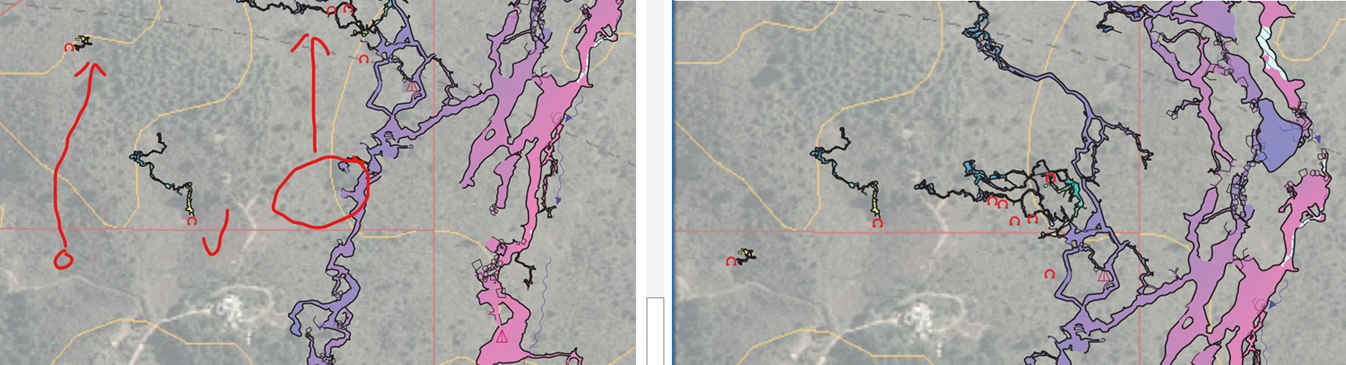
Martin Something bad happened between 6.0.0 and 6.0.5 that we only just noticed today (because for day to day work we only compile small sections of the cave). Therion 6.05 has moved some of our fixed stations about 100 m north (those specified with cs lat-long and cs EPSG:2193 NZTM) and others (specified with cs EPSG:27200 NZMG) stayed in their correct locations, severely distorting our cave. No errors reported, just outputs with large loop errors and distorted cave. Interestingly, it is the old archaic format NZMG that performs correctly and the modern and lat-long are relocated. The image below is located with NZMG, as is the cave entrance in the centre. The cave entrances left and right are located with either lat-long or NZTM. Before reporting this I thought I'd better at least try 6.0.6+3bc6556 I get a crash right away as the therion.log transcript below indicates. therion 6.0.6+3bc6556 (2022-04-21) - using Proj 9.0.0, compiled against 9.0.0 initialization file: C:\Program Files (x86)\Therion/therion.ini reading ... done configuration file: thconfig-GLMESM_System5000Map.thc reading ... done reading source files ... downloading the grid https://cdn.proj.org/nz_linz_nzgd2kgrid0005.tif... C:\Program Files (x86)\Therion\therion.exe: error -- couldn't download the grid writing xtherion file ... done Should I be using one of the new cs-trans or proj-* commands or is there something else? Regards Bruce -----Original Message----- From: Therion <therion-bounces@speleo.sk> On Behalf Of Martin Budaj Sent: Friday, 22 April 2022 07:32 To: List for Therion users <therion@speleo.sk> Subject: [Therion] new default settings Hi all, Therion has been supporting the advanced features of the Proj library for some time now. (Proj's purpose is to do transformations between coordinate systems.) This functionality was disabled by default and you could enable it using 'proj-auto' and 'proj-missing-grid' options in the initialization file. 'proj-auto' lets Proj choose the best transformation and you can set 'proj-missing-grid' to download a grid file (see <https://proj.org/usage/transformation.html#grid-based-datum-adjustments> https://proj.org/usage/transformation.html#grid-based-datum-adjustments) if the transformation needs it; see the therion book for details. The log file lists all the transformations chosen and used at the end. The latest commit (3bc6556) enables this "use the best transformation and download the grids if needed" functionality. We know that automatic downloads are a sensitive issue, but in this case we can trust the Proj library not to do any harm ( <https://proj.org/usage/network.html> https://proj.org/usage/network.html) and the user experience is much better. Could you check if this version works well with your data sets? The windows installer is available here: <https://github.com/therion/therion/actions/runs/2203811478> https://github.com/therion/therion/actions/runs/2203811478 (use the msys2 version which uses up-to-date Proj library; you need to be logged in to github to download it). M. _______________________________________________ Therion mailing list <mailto:Therion@speleo.sk> Therion@speleo.sk <https://mailman.speleo.sk/listinfo/therion> https://mailman.speleo.sk/listinfo/therion