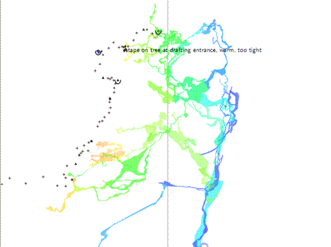
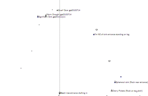
Related to the issue of the inclusion or exclusion of particular station symbols in pdf outputs, there is a long standing behaviour that has been frustrating me. I would like to create a pdf that has; -cave passage outlines, but no cave survey network information, and -fixed surface points with labels, and no surface drawings and no other surface survey network information. I have used these statements in a layout; symbol-hide group all symbol-show point station symbol-hide group cave-centreline symbol-hide point cave-station symbol-show group surface-centreline symbol-show point surface-station symbol-show point flag:entrance symbol-show point flag:sink symbol-show point flag:spring symbol-show point flag:doline symbol-show point flag:dig symbol-show point flag:continuation They more or less describe what I want (except for the surface centerline statement). I have used two source files. 'One' references cave data that has lots of drawings, plus a small amount of surface data and surface drawing. 'Two' references surface data (and a few cave stations) that is almost exclusively made up of fixed points (gps data) and has no drawings. If I reference 'one' only then I get the following image. Pretty much what I wanted, except for the surface survey stations (notice that I have 'symbol-show group surface-centreline' above, but the surface centerline is not plotted). If I reference 'two', then I also get pretty much what I want, except that some of the points that are displayed are cave-stations. The above two screenshots from pdfs are created with the same dataset and cover approximately the same area and are at approximately the same scale. So, apart from the minor exceptions mentioned, I would like to create a pdf map that is a superposition of the two screenshots. When I reference both sources 'one' and 'two', in the same thconfig file, the project compiles and outputs are produced. The problem is that the pdf output produced looks identical to 'one' above. Ie the source that includes mainly surface data is not included in the pdf. For this example other types of output such as .lox and .3d are created correctly. Would this be a bug? Or something I am doing wrong? Bruce _____ From: therion-bounces@speleo.sk [mailto:therion-bounces@speleo.sk] On Behalf Of Stacho Mudrak Sent: Thursday, 25 October 2012 3:46 a.m. To: List for Therion users Subject: Re: [Therion] Marked stations As Marco already mentioned, it can be done after playing a little bit with symbol show/hide. Well, I needed to run therion in debugger to see, what is going on. The problem is, that there are multiple "attributes" and therion does support only hide show for single symbol type. Therefore, specification is tricky. But in your case, this is what you can use: symbol-hide group centerline symbol-show point cave-station symbol-show point station:painted symbol-show point station:fixed First line hides all centerline symbols from everywhere (stations and shots). Second tells therion, that you want to show stations in the cave. But in fact - point cave-station itself does not show any symbol. It only specifies, that stations in the cave should be shown. Therefore 3. and 4. lines are needed to specify, that you want painted and fixed stations to be shown. In fact, if you use symbol-hide group centerline, and want to show some station afterwards, you need to specify explicitely both, whether you want to show stations in cave or on surface and which kind of stations you want to show. You can use also symbol-show point station to show all kinds of stations. And now I am not sure, whether I understand my self ;) But at least, this configuration seems to work on my data sample. It would be great to have some kind of query language, show/hide/color symbols... HTH, S.