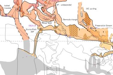
Hi Xavier Have just finished cleaning my caving gear after caving two days with Michael and others. Your message a nice distraction from the job of actually drawing the weekends surveying! Michael has been using previews and offsets for elevation maps for some time. I checked just now, and it is working with 5.3.15, and presume it must have been fine with 5.3.14 and earlier. The example here includes statements like these to create the map definition; map DeckExtensionElev290 \ -title "Middle Earth Cave Deck Extension Passages<br>Elevation looking 290 deg" \ -projection [elevation 290 deg] preview below MiddleEarthElev290Map DD-SandyWayElev290@MiddleEarth [-300 000 m] above #etc Regards Bruce -----Original Message----- From: therion-bounces@speleo.sk [mailto:therion-bounces@speleo.sk] On Behalf Of Xavier Pennec Sent: Monday, 16 June 2014 9:22 a.m. To: List for Therion users Subject: [Therion] preview above/below in elevation maps? Does anyone has experience with preview above/below in elevation maps? I use it quite often in plan maps, with the expected behavior, but when I try it in an elevation map, the "previewed" map does not appear at all in my pdf neither with below or above. I am wondering if I missed something in the intended behavior or if there is a bug in my layouts (although it does not work either if I don't load them). Thanks for your insights Xavier