Export centerline and/or stations to SHP without th2 files

Hi everyone, I have a survey with coordinates at the first station but I don't use th2 files. When I export to loch file, It works perfect, I can see the model in the correct place together with the DEM and surface image. When I try to export to SHP or kml I get empty layers because I don't use th2 files. What I don't understand is why the centerline / splayes / stations layers are empty as well. Is there a way to export to SHP / kml only the data from the th file? -- Omri

Hi, For shp, I never tried. For kml, I export the centerline + splays by exporting the model, not the map. For instance : export model -fmt kml -o Outputs/MyCave.kml Hope it helps, Xav
Le 18 nov. 2021 à 12:08, עמרי גסטר <omrigas@gmail.com> a écrit :
Hi everyone, I have a survey with coordinates at the first station but I don't use th2 files. When I export to loch file, It works perfect, I can see the model in the correct place together with the DEM and surface image. When I try to export to SHP or kml I get empty layers because I don't use th2 files. What I don't understand is why the centerline / splayes / stations layers are empty as well.
Is there a way to export to SHP / kml only the data from the th file?
-- Omri _______________________________________________ Therion mailing list Therion@speleo.sk https://mailman.speleo.sk/listinfo/therion
Thanks Xavier, it worked! So , after converting the KML to SHP I have a polyline of the cave centerline & spalyes. What I'm aiming for, are the stations with the absolute altitude. If I manage to get that, then I can calculate the relative depth of each station from the surface. On Thu, Nov 18, 2021 at 2:31 PM Xavier Robert < xavier.robert@univ-grenoble-alpes.fr> wrote:
Hi,
For shp, I never tried.
For kml, I export the centerline + splays by exporting the model, not the map. For instance : export model -fmt kml -o Outputs/MyCave.kml
Hope it helps,
Xav
Le 18 nov. 2021 à 12:08, עמרי גסטר <omrigas@gmail.com> a écrit :
Hi everyone, I have a survey with coordinates at the first station but I don't use th2 files. When I export to loch file, It works perfect, I can see the model in the correct place together with the DEM and surface image. When I try to export to SHP or kml I get empty layers because I don't use th2 files. What I don't understand is why the centerline / splayes / stations layers are empty as well.
Is there a way to export to SHP / kml only the data from the th file?
-- Omri _______________________________________________ Therion mailing list Therion@speleo.sk https://mailman.speleo.sk/listinfo/therion
_______________________________________________ Therion mailing list Therion@speleo.sk https://mailman.speleo.sk/listinfo/therion
-- בברכה, עמרי גסטר 052-6124995
Hi, I never focussed on that but : If i do not mistake, you have the info of the altitude of each station in the sql database of the cave/system you may export. You may need to use some sql and/python queries to extract what you want. I am sure this is quite easy to compute, the last version of CaveView (https://aardgoose.github.io/CaveView.js/) is indicating that nicely. If your aim is to get the depth from the surface for only few points, you may tried tu use CaveView (Juste open a web page that is also using a CaveView Viewer, and then drag and grad your .lox file in the 3D viewer panel). Cheers Xavier
Le 18 nov. 2021 à 15:11, עמרי גסטר <omrigas@gmail.com> a écrit :
Thanks Xavier, it worked!
So , after converting the KML to SHP I have a polyline of the cave centerline & spalyes. What I'm aiming for, are the stations with the absolute altitude. If I manage to get that, then I can calculate the relative depth of each station from the surface.
On Thu, Nov 18, 2021 at 2:31 PM Xavier Robert <xavier.robert@univ-grenoble-alpes.fr <mailto:xavier.robert@univ-grenoble-alpes.fr>> wrote: Hi,
For shp, I never tried.
For kml, I export the centerline + splays by exporting the model, not the map. For instance : export model -fmt kml -o Outputs/MyCave.kml
Hope it helps,
Xav
Le 18 nov. 2021 à 12:08, עמרי גסטר <omrigas@gmail.com <mailto:omrigas@gmail.com>> a écrit :
Hi everyone, I have a survey with coordinates at the first station but I don't use th2 files. When I export to loch file, It works perfect, I can see the model in the correct place together with the DEM and surface image. When I try to export to SHP or kml I get empty layers because I don't use th2 files. What I don't understand is why the centerline / splayes / stations layers are empty as well.
Is there a way to export to SHP / kml only the data from the th file?
-- Omri _______________________________________________ Therion mailing list Therion@speleo.sk <mailto:Therion@speleo.sk> https://mailman.speleo.sk/listinfo/therion <https://mailman.speleo.sk/listinfo/therion>
_______________________________________________ Therion mailing list Therion@speleo.sk <mailto:Therion@speleo.sk> https://mailman.speleo.sk/listinfo/therion <https://mailman.speleo.sk/listinfo/therion>
-- בברכה, עמרי גסטר 052-6124995 _______________________________________________ Therion mailing list Therion@speleo.sk https://mailman.speleo.sk/listinfo/therion
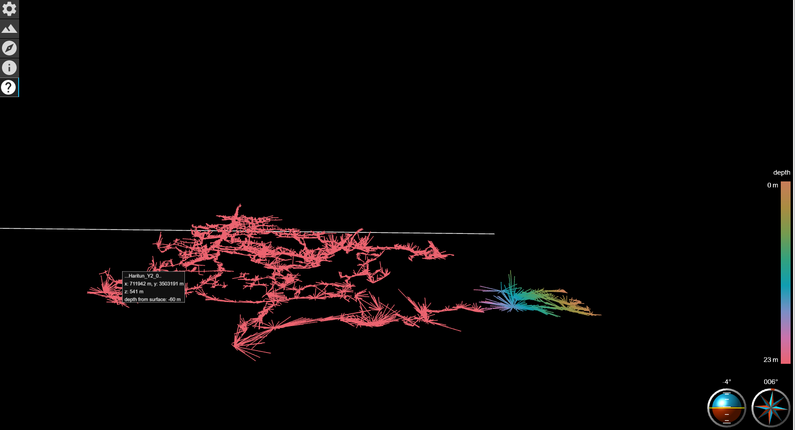
Thanks, I know cave view, it is very useful. I noticed that if you press with the mouse on any location it gives you the hight from surface. There is a shading called depth below surface, but it stops at 23m (by the way is this a bug?), I know that there there are places with far greater depth then 23m. I'm attaching a screenshot with the problem. [image: image.png] On Thu, Nov 18, 2021 at 4:26 PM Xavier Robert < xavier.robert@univ-grenoble-alpes.fr> wrote:
Hi,
I never focussed on that but :
- If i do not mistake, you have the info of the altitude of each station in the sql database of the cave/system you may export. You may need to use some sql and/python queries to extract what you want. - I am sure this is quite easy to compute, the last version of CaveView (https://aardgoose.github.io/CaveView.js/) is indicating that nicely. If your aim is to get the depth from the surface for only few points, you may tried tu use CaveView (Juste open a web page that is also using a CaveView Viewer, and then drag and grad your .lox file in the 3D viewer panel).
Cheers
Xavier
Le 18 nov. 2021 à 15:11, עמרי גסטר <omrigas@gmail.com> a écrit :
Thanks Xavier, it worked!
So , after converting the KML to SHP I have a polyline of the cave centerline & spalyes. What I'm aiming for, are the stations with the absolute altitude. If I manage to get that, then I can calculate the relative depth of each station from the surface.
On Thu, Nov 18, 2021 at 2:31 PM Xavier Robert < xavier.robert@univ-grenoble-alpes.fr> wrote:
Hi,
For shp, I never tried.
For kml, I export the centerline + splays by exporting the model, not the map. For instance : export model -fmt kml -o Outputs/MyCave.kml
Hope it helps,
Xav
Le 18 nov. 2021 à 12:08, עמרי גסטר <omrigas@gmail.com> a écrit :
Hi everyone, I have a survey with coordinates at the first station but I don't use th2 files. When I export to loch file, It works perfect, I can see the model in the correct place together with the DEM and surface image. When I try to export to SHP or kml I get empty layers because I don't use th2 files. What I don't understand is why the centerline / splayes / stations layers are empty as well.
Is there a way to export to SHP / kml only the data from the th file?
-- Omri _______________________________________________ Therion mailing list Therion@speleo.sk https://mailman.speleo.sk/listinfo/therion
_______________________________________________ Therion mailing list Therion@speleo.sk https://mailman.speleo.sk/listinfo/therion
-- בברכה, עמרי גסטר 052-6124995 _______________________________________________ Therion mailing list Therion@speleo.sk https://mailman.speleo.sk/listinfo/therion
_______________________________________________ Therion mailing list Therion@speleo.sk https://mailman.speleo.sk/listinfo/therion
-- בברכה, עמרי גסטר 052-6124995

Hi Omri, have you tried exporting model to .SHP files? export model -o cave.shp If you export map, I am not sure about altitude information in it. It is a long time ago we were working on it, but there were some differences when exporting map (2D) and model (3D) data. If you export model to .SHP files, it creates 3 layers - stations3d, shots3d and walls3d with proper 3D geometry and metadata of these features. S. On Thu, 18 Nov 2021 at 12:09, עמרי גסטר <omrigas@gmail.com> wrote:
Hi everyone, I have a survey with coordinates at the first station but I don't use th2 files. When I export to loch file, It works perfect, I can see the model in the correct place together with the DEM and surface image. When I try to export to SHP or kml I get empty layers because I don't use th2 files. What I don't understand is why the centerline / splayes / stations layers are empty as well.
Is there a way to export to SHP / kml only the data from the th file?
-- Omri _______________________________________________ Therion mailing list Therion@speleo.sk https://mailman.speleo.sk/listinfo/therion

On Thu, Nov 18, 2021 at 12:09 PM עמרי גסטר <omrigas@gmail.com> wrote:
When I try to export to SHP or kml I get empty layers because I don't use th2 files. What I don't understand is why the centerline / splayes / stations layers are empty as well.
Hi, there is a bug in the embedded shapefile library if it's used under Windows. The latest commit contains a local fix, so it should work well now. Martin
Hi Stacho & Martin I ran it with the new release, it world good now. Thanks! On Wed, Nov 24, 2021, 9:23 PM Martin Budaj <m.budaj@gmail.com> wrote:
On Thu, Nov 18, 2021 at 12:09 PM עמרי גסטר <omrigas@gmail.com> wrote:
When I try to export to SHP or kml I get empty layers because I don't use th2 files. What I don't understand is why the centerline / splayes / stations layers are empty as well.
Hi,
there is a bug in the embedded shapefile library if it's used under Windows. The latest commit contains a local fix, so it should work well now.
Martin _______________________________________________ Therion mailing list Therion@speleo.sk https://mailman.speleo.sk/listinfo/therion
participants (4)
-
 Martin Budaj
-
 Stacho Mudrak
-
 Xavier Robert
-
 עמרי גסטר