scrap without stations keeps the original sketch in Topodroid

Hi all, I want to raise a question I've been having with my self... when I'm in the cave I use Topodroid to make the sketch. when I export the map in Therion with "debug on" I see the changes that Therion makes which make the final map different from the sketch I made in Topodroid (sometimes it is a big difference). a few days ago I noticed that if I make a new scrap and move all the map elements that I draw except the stations, the map turns out exactly as I draw it on Topodroid. As I understand it, Therion change the map to overcome or compensate errors or Deviations, especially when there are loops involved, but wouldn't it be more accurate to stick to the original sketch that I drew with Topodroid in the cave? what do you think? Omri Gaster

Hi Omri, You cannot have a scrap without any survey points in it. each scrap or th2 file needs 2 or greater survey stations in it to function correctly without warping the image. extended elevations are a bit different (and sometimes need careful adjustment of the legs to fold the extended elevation in the correct way). [Caviat, I know you can have a th2 file with no survey stations in it, but we're not creating rocks today wookware.org/surveys/therion/testrocks]. Regards, Alastair Gott. AlastairGott@hotmail.com, M: 07931779380. ________________________________ From: Therion <therion-bounces@speleo.sk> on behalf of עמרי גסטר <omrigas@gmail.com> Sent: 06 October 2019 20:31 To: List for Therion users <therion@speleo.sk> Subject: [Therion] scrap without stations keeps the original sketch in Topodroid Hi all, I want to raise a question I've been having with my self... when I'm in the cave I use Topodroid to make the sketch. when I export the map in Therion with "debug on" I see the changes that Therion makes which make the final map different from the sketch I made in Topodroid (sometimes it is a big difference). a few days ago I noticed that if I make a new scrap and move all the map elements that I draw except the stations, the map turns out exactly as I draw it on Topodroid. As I understand it, Therion change the map to overcome or compensate errors or Deviations, especially when there are loops involved, but wouldn't it be more accurate to stick to the original sketch that I drew with Topodroid in the cave? what do you think? Omri Gaster

On 07/10/2019 07:33, alastair gott wrote:
[Caviat, I know you can have a th2 file with no survey stations in it, but we're not creating rocks today
That file does have 2 stations in it :)
wookware.org/surveys/therion/testrocks].Hi all, I want to raise a question I've been having with my self... when I'm in the cave I use Topodroid to make the sketch. when I export the map in Therion with "debug on" I see the changes that Therion makes which make the final map different from the sketch I made in Topodroid (sometimes it is a big difference). a few days ago I noticed that if I make a new scrap and move all the map elements that I draw except the stations, the map turns out exactly as I draw it on Topodroid> As I understand it, Therion change the map to overcome or compensate errors or Deviations, especially when there are loops involved, but wouldn't it be more accurate to stick to the original sketch that I drew with Topodroid in the cave? what do you think?
Omri Gaster
Without an example, I'm not sure what you mean, can you provide an example. You are correct that Therion 'bends' the cave to fit the corrected centreline. If you are getting a large distortion when you draw a survey up in Therion, it would mean the position of the stations was not very good in the original drawing, which would be an explanation if you were drawing on paper. However you are using Topodroid, so the stations should only be moved a small amount for a reasonable survey quality. I would be suspicions of large movement of walls from a Topodoid file. Does this happen with all your surveys? I personally would start by checking the loop closure, then see if all the stations are named correctly in the th2 and that there are no duplicates

7. 10. 2019 v 8:33, alastair gott <alastairgott@hotmail.com>:
I know you can have a th2 file with no survey stations in it
There MUST be one or more point station in each scrap except section scraps. Each scrap MUST have (geo)reference point(s) which Therion uses to properly localize it. If you use only one station there MUST be done manual scale of scrap. If you draw section there MUST be manual scale done. Martin
7. 10. 2019 v 8:33, alastair gott <alastairgott@hotmail.com>:
wookware.org/surveys/therion/testrocks <http://wookware.org/surveys/therion/testrocks]> There are not stations in the pdf output of data you linked but it is because of line "symbol-hide group cave-centreline“ in thconfig.
There are two stations in scrap in original data: point 342.0 518.0 station -name 1 point 688.0 268.0 station -name 2 Martin

Omri, Alastair I would have thought it almost impossible to draw a whole cave without any point stations in the th2 files, but yesterday a colleague who just self-taught themselves Therion presented me with a 5km long cave that has no point stations defined in the th2 (it has survey stations of course, just not drawn in the scraps). It is also one of the better looking Therion maps I have come across. I have yet to pick it apart to see why it works and what the implications are. My suspicion is that it does not properly morph the sketches to the survey network. In response to Omri’s question – if your survey is perfect, and the field sketch as well, then of course an unmorphed drawing will be just fine. If you have a real survey and sketch, subject to distortions due to loop closures over multiple trips (multiple files), then the loops will not match, and the drawing will need to be morphed due to loop closures and due to scrap joins where the scraps are in different files or different locations in the same file. If, when using Topodroid, as I have seen people over here do, you accumulate all of your survey trips in a single file, and end up with one huge sketch for the cave, in which you manually compensate for any misclosures, then Therion has nothing much left to do. In that case, it might be fine to do as you describe. Until someone finds the next big breakthrough passage, then it may or may not be. Bruce From: Therion <therion-bounces@speleo.sk> On Behalf Of alastair gott Sent: Monday, 7 October 2019 19:34 To: List for Therion users <therion@speleo.sk> Subject: Re: [Therion] scrap without stations keeps the original sketch in Topodroid Hi Omri, You cannot have a scrap without any survey points in it. each scrap or th2 file needs 2 or greater survey stations in it to function correctly without warping the image. extended elevations are a bit different (and sometimes need careful adjustment of the legs to fold the extended elevation in the correct way). [Caviat, I know you can have a th2 file with no survey stations in it, but we're not creating rocks today wookware.org/surveys/therion/testrocks]. Regards, Alastair Gott. AlastairGott@hotmail.com <mailto:AlastairGott@hotmail.com> , M: 07931779380. _____ From: Therion <therion-bounces@speleo.sk <mailto:therion-bounces@speleo.sk>
on behalf of עמרי גסטר <omrigas@gmail.com <mailto:omrigas@gmail.com> > Sent: 06 October 2019 20:31 To: List for Therion users <therion@speleo.sk <mailto:therion@speleo.sk> > Subject: [Therion] scrap without stations keeps the original sketch in Topodroid
Hi all, I want to raise a question I've been having with my self... when I'm in the cave I use Topodroid to make the sketch. when I export the map in Therion with "debug on" I see the changes that Therion makes which make the final map different from the sketch I made in Topodroid (sometimes it is a big difference). a few days ago I noticed that if I make a new scrap and move all the map elements that I draw except the stations, the map turns out exactly as I draw it on Topodroid. As I understand it, Therion change the map to overcome or compensate errors or Deviations, especially when there are loops involved, but wouldn't it be more accurate to stick to the original sketch that I drew with Topodroid in the cave? what do you think? Omri Gaster
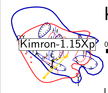
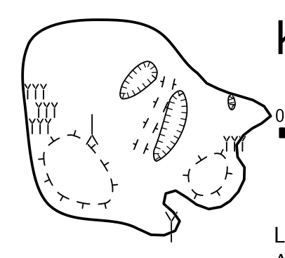
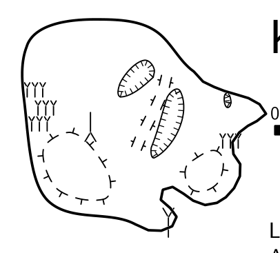
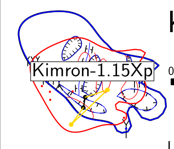
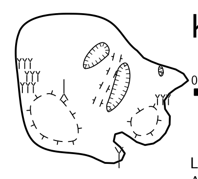
Here is an example of what I mean: the cave I'll show is a pit and I made plan sketches as a horizontal sections. The extended profile turned out good. one of the plan sketches is distorted as you can see here: [image: image.png] The original scrap is Kimron-1_15Xp, the new scrap is scrap26, so, I moved all the map elements except the stations, so now my scrap look like this ( the stations still exists in the .th file): scrap Kimron-1_15Xp -projection plan -scale [0 0 20 0 0 0 1 0 m] point 146.75 -130.52 station -name "1_9" point 162.64 -129.64 station -name "1_10" point 186.31 -124.43 station -name "1_11" point 198.19 -127.12 station -name "1_12" point 176.97 -115.01 station -name "1_13" point 191.00 -109.43 station -name "1_14" point 194.21 -92.76 station -name "1_15" point 182.67 -112.46 station -name "1_16" point 186.84 -71.79 station -name "1_17" endscrap scrap scrap26 -projection plan -scale [0 0 20 0 0 0 1 0 m] line wall -close on..... when I ran scrap26 the map is correct: [image: image.png] I used this Technic several times and it worked every time. On Mon, Oct 7, 2019 at 12:23 PM Bruce Mutton <bruce@tomo.co.nz> wrote:
Omri, Alastair
I would have thought it almost impossible to draw a whole cave without any point stations in the th2 files, but yesterday a colleague who just self-taught themselves Therion presented me with a 5km long cave that has no point stations defined in the th2 (it has survey stations of course, just not drawn in the scraps). It is also one of the better looking Therion maps I have come across. I have yet to pick it apart to see why it works and what the implications are.
My suspicion is that it does not properly morph the sketches to the survey network.
In response to Omri’s question – if your survey is perfect, and the field sketch as well, then of course an unmorphed drawing will be just fine. If you have a real survey and sketch, subject to distortions due to loop closures over multiple trips (multiple files), then the loops will not match, and the drawing will need to be morphed due to loop closures and due to scrap joins where the scraps are in different files or different locations in the same file.
If, when using Topodroid, as I have seen people over here do, you accumulate all of your survey trips in a single file, and end up with one huge sketch for the cave, in which you manually compensate for any misclosures, then Therion has nothing much left to do. In that case, it might be fine to do as you describe. Until someone finds the next big breakthrough passage, then it may or may not be.
Bruce
*From:* Therion <therion-bounces@speleo.sk> *On Behalf Of *alastair gott *Sent:* Monday, 7 October 2019 19:34 *To:* List for Therion users <therion@speleo.sk> *Subject:* Re: [Therion] scrap without stations keeps the original sketch in Topodroid
Hi Omri,
You cannot have a scrap without any survey points in it. each scrap or th2 file needs 2 or greater survey stations in it to function correctly without warping the image.
extended elevations are a bit different (and sometimes need careful adjustment of the legs to fold the extended elevation in the correct way).
[Caviat, I know you can have a th2 file with no survey stations in it, but we're not creating rocks today wookware.org/surveys/therion/testrocks].
Regards, Alastair Gott.
AlastairGott@hotmail.com, M: 07931779380. ------------------------------
*From:* Therion <therion-bounces@speleo.sk> on behalf of עמרי גסטר < omrigas@gmail.com> *Sent:* 06 October 2019 20:31 *To:* List for Therion users <therion@speleo.sk> *Subject:* [Therion] scrap without stations keeps the original sketch in Topodroid
Hi all,
I want to raise a question I've been having with my self...
when I'm in the cave I use Topodroid to make the sketch. when I export the map in Therion with "debug on" I see the changes that Therion makes which make the final map different from the sketch I made in Topodroid (sometimes it is a big difference).
a few days ago I noticed that if I make a new scrap and move all the map elements that I draw except the stations, the map turns out exactly as I draw it on Topodroid.
As I understand it, Therion change the map to overcome or compensate errors or Deviations, especially when there are loops involved, but wouldn't it be more accurate to stick to the original sketch that I drew with Topodroid in the cave?
what do you think?
Omri Gaster _______________________________________________ Therion mailing list Therion@speleo.sk https://mailman.speleo.sk/listinfo/therion
-- בברכה, עמרי גסטר 052-6124995
Hi Omri, I think it depends on how you've surveyed this chamber, without seeing how 1_9 is connected to 1_17 on your th file, I think it would be very difficult to work out why the programme is distorting the file so much. I suspect now you have run it (scrap 26) without any survey points, you have taken out the reason why the programme is warping your image. therefore it's probably a problem with your th file. As far as my limited knowledge takes me, there are a couple of reasons why it might have warped your image. 1) a series of points connected up from 1_9 to 1_17 may have a small error in them. 2) you may have accidentally equated two points in your th file. (for example 1_9 to 1_10, 1_10 to 1_11, 1_11 1_9 0 0 0, 3) If you have outputted this at a higher "cave" level (when you ran Kimron-1_15Xp) and linked in more than one of the pits in the floor, this could also cause warping when the programme tries to join several th2 files together. This is so that it can create the best fit with where you've placed the walls. Might be an idea to show us your th file. Regards, Alastair Gott. AlastairGott@hotmail.com, M: 07931779380. ________________________________ From: Therion <therion-bounces@speleo.sk> on behalf of עמרי גסטר <omrigas@gmail.com> Sent: 07 October 2019 17:00 To: List for Therion users <therion@speleo.sk> Subject: Re: [Therion] ***UNCHECKED*** RE: scrap without stations keeps the original sketch in Topodroid Here is an example of what I mean: the cave I'll show is a pit and I made plan sketches as a horizontal sections. The extended profile turned out good. one of the plan sketches is distorted as you can see here: [image.png] The original scrap is Kimron-1_15Xp, the new scrap is scrap26, so, I moved all the map elements except the stations, so now my scrap look like this ( the stations still exists in the .th file): scrap Kimron-1_15Xp -projection plan -scale [0 0 20 0 0 0 1 0 m] point 146.75 -130.52 station -name "1_9" point 162.64 -129.64 station -name "1_10" point 186.31 -124.43 station -name "1_11" point 198.19 -127.12 station -name "1_12" point 176.97 -115.01 station -name "1_13" point 191.00 -109.43 station -name "1_14" point 194.21 -92.76 station -name "1_15" point 182.67 -112.46 station -name "1_16" point 186.84 -71.79 station -name "1_17" endscrap scrap scrap26 -projection plan -scale [0 0 20 0 0 0 1 0 m] line wall -close on..... when I ran scrap26 the map is correct: [image.png] I used this Technic several times and it worked every time. On Mon, Oct 7, 2019 at 12:23 PM Bruce Mutton <bruce@tomo.co.nz<mailto:bruce@tomo.co.nz>> wrote: Omri, Alastair I would have thought it almost impossible to draw a whole cave without any point stations in the th2 files, but yesterday a colleague who just self-taught themselves Therion presented me with a 5km long cave that has no point stations defined in the th2 (it has survey stations of course, just not drawn in the scraps). It is also one of the better looking Therion maps I have come across. I have yet to pick it apart to see why it works and what the implications are. My suspicion is that it does not properly morph the sketches to the survey network. In response to Omri’s question – if your survey is perfect, and the field sketch as well, then of course an unmorphed drawing will be just fine. If you have a real survey and sketch, subject to distortions due to loop closures over multiple trips (multiple files), then the loops will not match, and the drawing will need to be morphed due to loop closures and due to scrap joins where the scraps are in different files or different locations in the same file. If, when using Topodroid, as I have seen people over here do, you accumulate all of your survey trips in a single file, and end up with one huge sketch for the cave, in which you manually compensate for any misclosures, then Therion has nothing much left to do. In that case, it might be fine to do as you describe. Until someone finds the next big breakthrough passage, then it may or may not be. Bruce From: Therion <therion-bounces@speleo.sk<mailto:therion-bounces@speleo.sk>> On Behalf Of alastair gott Sent: Monday, 7 October 2019 19:34 To: List for Therion users <therion@speleo.sk<mailto:therion@speleo.sk>> Subject: Re: [Therion] scrap without stations keeps the original sketch in Topodroid Hi Omri, You cannot have a scrap without any survey points in it. each scrap or th2 file needs 2 or greater survey stations in it to function correctly without warping the image. extended elevations are a bit different (and sometimes need careful adjustment of the legs to fold the extended elevation in the correct way). [Caviat, I know you can have a th2 file with no survey stations in it, but we're not creating rocks today wookware.org/surveys/therion/testrocks<https://nam11.safelinks.protection.outlook.com/?url=http%3A%2F%2Fwookware.org%2Fsurveys%2Ftherion%2Ftestrocks&data=02%7C01%7C%7C906c3422c0644973cd2f08d74b42f8f4%7C84df9e7fe9f640afb435aaaaaaaaaaaa%7C1%7C0%7C637060623332440451&sdata=0Avg9HjM7sIrATrlO4%2BIKtYiDtyXjn0OzVTqIcwhGlo%3D&reserved=0>]. Regards, Alastair Gott. AlastairGott@hotmail.com<mailto:AlastairGott@hotmail.com>, M: 07931779380. ________________________________ From: Therion <therion-bounces@speleo.sk<mailto:therion-bounces@speleo.sk>> on behalf of עמרי גסטר <omrigas@gmail.com<mailto:omrigas@gmail.com>> Sent: 06 October 2019 20:31 To: List for Therion users <therion@speleo.sk<mailto:therion@speleo.sk>> Subject: [Therion] scrap without stations keeps the original sketch in Topodroid Hi all, I want to raise a question I've been having with my self... when I'm in the cave I use Topodroid to make the sketch. when I export the map in Therion with "debug on" I see the changes that Therion makes which make the final map different from the sketch I made in Topodroid (sometimes it is a big difference). a few days ago I noticed that if I make a new scrap and move all the map elements that I draw except the stations, the map turns out exactly as I draw it on Topodroid. As I understand it, Therion change the map to overcome or compensate errors or Deviations, especially when there are loops involved, but wouldn't it be more accurate to stick to the original sketch that I drew with Topodroid in the cave? what do you think? Omri Gaster _______________________________________________ Therion mailing list Therion@speleo.sk<mailto:Therion@speleo.sk> https://mailman.speleo.sk/listinfo/therion<https://nam11.safelinks.protection.outlook.com/?url=https%3A%2F%2Fmailman.speleo.sk%2Flistinfo%2Ftherion&data=02%7C01%7C%7C906c3422c0644973cd2f08d74b42f8f4%7C84df9e7fe9f640afb435aaaaaaaaaaaa%7C1%7C0%7C637060623332450461&sdata=sLuGe4zo6a%2F7QhBhRp5dS%2BMLULylFLaqLwnagjRt6OE%3D&reserved=0> -- בברכה, עמרי גסטר 052-6124995
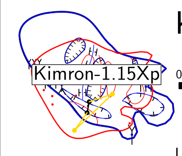

Hi Omri, the problem is, that stations from pocket-topo XVI file are positioned differently than the final position calculated after loop closure. Therefore the problem with distortions. Your loop has a relatively large error (9%) and it is vertical one - therefore X-Y position of points is changed significantly. I would suggest using just two stations in your 15X scrap for calibration (those, that are closest to the horizontal level of this section - e.g. 1_15, 1_16, 1_18) and let therion to plot other stations in this scrap automatically (using scrap option -stations [1_9 1_10 1_11 1_12 1_13 1_14]). S. On Mon, 7 Oct 2019 at 18:30, עמרי גסטר <omrigas@gmail.com> wrote:
Here is an example of what I mean:
the cave I'll show is a pit and I made plan sketches as a horizontal sections. The extended profile turned out good. one of the plan sketches is distorted as you can see here:
[image: image.png]
The original scrap is Kimron-1_15Xp, the new scrap is scrap26, so, I moved all the map elements except the stations, so now my scrap look like this ( the stations still exists in the .th file):
scrap Kimron-1_15Xp -projection plan -scale [0 0 20 0 0 0 1 0 m]
point 146.75 -130.52 station -name "1_9" point 162.64 -129.64 station -name "1_10" point 186.31 -124.43 station -name "1_11" point 198.19 -127.12 station -name "1_12" point 176.97 -115.01 station -name "1_13" point 191.00 -109.43 station -name "1_14" point 194.21 -92.76 station -name "1_15" point 182.67 -112.46 station -name "1_16" point 186.84 -71.79 station -name "1_17"
endscrap scrap scrap26 -projection plan -scale [0 0 20 0 0 0 1 0 m]
line wall -close on.....
when I ran scrap26 the map is correct:
[image: image.png]
I used this Technic several times and it worked every time.
On Mon, Oct 7, 2019 at 12:23 PM Bruce Mutton <bruce@tomo.co.nz> wrote:
Omri, Alastair
I would have thought it almost impossible to draw a whole cave without any point stations in the th2 files, but yesterday a colleague who just self-taught themselves Therion presented me with a 5km long cave that has no point stations defined in the th2 (it has survey stations of course, just not drawn in the scraps). It is also one of the better looking Therion maps I have come across. I have yet to pick it apart to see why it works and what the implications are.
My suspicion is that it does not properly morph the sketches to the survey network.
In response to Omri’s question – if your survey is perfect, and the field sketch as well, then of course an unmorphed drawing will be just fine. If you have a real survey and sketch, subject to distortions due to loop closures over multiple trips (multiple files), then the loops will not match, and the drawing will need to be morphed due to loop closures and due to scrap joins where the scraps are in different files or different locations in the same file.
If, when using Topodroid, as I have seen people over here do, you accumulate all of your survey trips in a single file, and end up with one huge sketch for the cave, in which you manually compensate for any misclosures, then Therion has nothing much left to do. In that case, it might be fine to do as you describe. Until someone finds the next big breakthrough passage, then it may or may not be.
Bruce
*From:* Therion <therion-bounces@speleo.sk> *On Behalf Of *alastair gott *Sent:* Monday, 7 October 2019 19:34 *To:* List for Therion users <therion@speleo.sk> *Subject:* Re: [Therion] scrap without stations keeps the original sketch in Topodroid
Hi Omri,
You cannot have a scrap without any survey points in it. each scrap or th2 file needs 2 or greater survey stations in it to function correctly without warping the image.
extended elevations are a bit different (and sometimes need careful adjustment of the legs to fold the extended elevation in the correct way).
[Caviat, I know you can have a th2 file with no survey stations in it, but we're not creating rocks today wookware.org/surveys/therion/testrocks ].
Regards, Alastair Gott.
AlastairGott@hotmail.com, M: 07931779380. ------------------------------
*From:* Therion <therion-bounces@speleo.sk> on behalf of עמרי גסטר < omrigas@gmail.com> *Sent:* 06 October 2019 20:31 *To:* List for Therion users <therion@speleo.sk> *Subject:* [Therion] scrap without stations keeps the original sketch in Topodroid
Hi all,
I want to raise a question I've been having with my self...
when I'm in the cave I use Topodroid to make the sketch. when I export the map in Therion with "debug on" I see the changes that Therion makes which make the final map different from the sketch I made in Topodroid (sometimes it is a big difference).
a few days ago I noticed that if I make a new scrap and move all the map elements that I draw except the stations, the map turns out exactly as I draw it on Topodroid.
As I understand it, Therion change the map to overcome or compensate errors or Deviations, especially when there are loops involved, but wouldn't it be more accurate to stick to the original sketch that I drew with Topodroid in the cave?
what do you think?
Omri Gaster _______________________________________________ Therion mailing list Therion@speleo.sk https://mailman.speleo.sk/listinfo/therion
-- בברכה, עמרי גסטר 052-6124995 _______________________________________________ Therion mailing list Therion@speleo.sk https://mailman.speleo.sk/listinfo/therion
12. 10. 2019 v 17:15, Stacho Mudrak <lists@group-s.sk>: I would suggest using just two stations in your 15X scrap for calibration (those, that are closest to the horizontal level of this section - e.g. 1_15, 1_16, 1_18) Stacho, is there any reason to use for calibrating/(geo)referencing scrap with stations which are outside of that scrap? Martin

Hi Omri, Do you use a distoX when you survey the cave ? Otherwise, it is normal that therion change the drawing since usually the drawing differs from the measurements. Best, Phil
On 6 Oct 2019, at 21:31, עמרי גסטר <omrigas@gmail.com> wrote:
Hi all, I want to raise a question I've been having with my self... when I'm in the cave I use Topodroid to make the sketch. when I export the map in Therion with "debug on" I see the changes that Therion makes which make the final map different from the sketch I made in Topodroid (sometimes it is a big difference). a few days ago I noticed that if I make a new scrap and move all the map elements that I draw except the stations, the map turns out exactly as I draw it on Topodroid.
As I understand it, Therion change the map to overcome or compensate errors or Deviations, especially when there are loops involved, but wouldn't it be more accurate to stick to the original sketch that I drew with Topodroid in the cave? what do you think?
Omri Gaster _______________________________________________ Therion mailing list Therion@speleo.sk https://mailman.speleo.sk/listinfo/therion
participants (7)
-
 alastair gott
-
 Andrew Atkinson
-
 Bruce Mutton
-
 Martin Sluka
-
 Philippe Vernant
-
 Stacho Mudrak
-
 עמרי גסטר