Disconnected centrelines - Extended Elevation Control

I am braving the creation of some extended elevations of some main routes through a cave with a number of branches, loops, through trips and hopefully to include a nearby cave. Looking at the attachment First-Sample. I have an extended elevation that traverses a number of centrelines, some in the direction of survey, some against the direction of survey and one loop, which itself traverses a couple of surveys. It looks simple, but was a challenge, although it now looks how I want it to. Along the way to building it, there were plenty of times when there were random offsets that I had no control over. Although I have some insights as to why that might have been, and think I understand extend start, ignore, hide, there were plenty of times when it appeared that large offsets were occurring for no apparent reason. Anyway, the attached First-Sample. looks as I want it. Now I want to add another very short cave, which is connected by a long series of survey centrelines, although these centrelines are not to be part of this elevation, so are not included in the centreline maps I have created. See the attached 2caves-Sample. The second cave, and small part of surface survey, should ideally be located just to the right of the main elevation, because that is where, in reality there is a small gap between them. There is no survey of the gap of course - the survey goes around the long cave passages and surface to get there! (And there are gps fixed stations as well, so the surveys could potentially be disconnected, but that might mess with the plan maps - as usual there is a bit of misclose!) I have tried using a start statement for each, and a start statement for only one of them. This has no effect, and even if it did, there is not much chance it would produce the result I wanted. Is there a way to control the starting location of this second piece of (disconnected) centreline? Bruce

I had this problem for two pits not connected and i resolve it by using a surface suvey Guy De : Bruce Mutton via Therion Envoyé le :samedi 8 avril 2017 00:52 À : 'List for Therion users' Cc : Bruce Mutton Objet :[Therion] Disconnected centrelines - Extended Elevation Control I am braving the creation of some extended elevations of some main routes through a cave with a number of branches, loops, through trips and hopefully to include a nearby cave. Looking at the attachment First-Sample… I have an extended elevation that traverses a number of centrelines, some in the direction of survey, some against the direction of survey and one loop, which itself traverses a couple of surveys. It looks simple, but was a challenge, although it now looks how I want it to. Along the way to building it, there were plenty of times when there were random offsets that I had no control over. Although I have some insights as to why that might have been, and think I understand extend start, ignore, hide, there were plenty of times when it appeared that large offsets were occurring for no apparent reason. Anyway, the attached First-Sample… looks as I want it. Now I want to add another very short cave, which is connected by a long series of survey centrelines, although these centrelines are not to be part of this elevation, so are not included in the centreline maps I have created. See the attached 2caves-Sample… The second cave, and small part of surface survey, should ideally be located just to the right of the main elevation, because that is where, in reality there is a small gap between them. There is no survey of the gap of course – the survey goes around the long cave passages and surface to get there! (And there are gps fixed stations as well, so the surveys could potentially be disconnected, but that might mess with the plan maps – as usual there is a bit of misclose!) I have tried using a start statement for each, and a start statement for only one of them. This has no effect, and even if it did, there is not much chance it would produce the result I wanted. Is there a way to control the starting location of this second piece of (disconnected) centreline? Bruce

I had thought of it, and decided that it would compromise the integrity of the dataset, the other outputs, because there is no passage or sight-line between the two. However I think it would work, and might be acceptable .in the middle of the next mind bending elevation just now, so will try it later on and report back eventually. Another option might be to define a separate map, and then insert one pdf into the other as a map-image. Both options feel a little bit like hacks. Bruce From: Therion [mailto:therion-bounces@speleo.sk] On Behalf Of Martin Sluka via Therion Sent: Saturday, 8 April 2017 7:31 PM To: List for Therion users <therion@speleo.sk> Cc: Martin Sluka <martinsluka@mac.com> Subject: Re: [Therion] Disconnected centrelines - Extended Elevation Control 8. 4. 2017 v 0:51, Bruce Mutton via Therion <therion@speleo.sk <mailto:therion@speleo.sk> >: and think I understand extend start, ignore, hide Bruce, have you try to create a nosurvey shot? Just between two stations you want to be in correct places? m.s.
Martin I think nosurvey will be the best compromise (when I can get the nosurveys to stop crashing the extended elevations). I can set it to approximate and duplicate, so that is shows up yellow and dashed with my metapost customisation. However
nosurvey is nosurvey.
True, in the labyrinths of Therion maybe. However I don't think 'nosurvey' legs are distinguished from other survey leg types in the outputs, so not necessarily 'nosurvey' in the mind of those viewing the outputs. Unless I am missing something. How is the recipient of these outputs to know that there is a 'nosurvey leg? In the outputs below, there are perhaps subtle clues because I have included splays and passage walls, but nothing that would stand out to an inexperienced recipient. Bruce
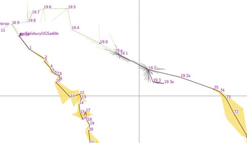
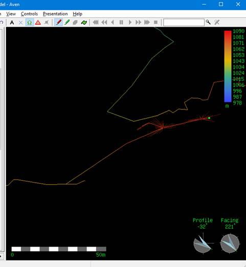
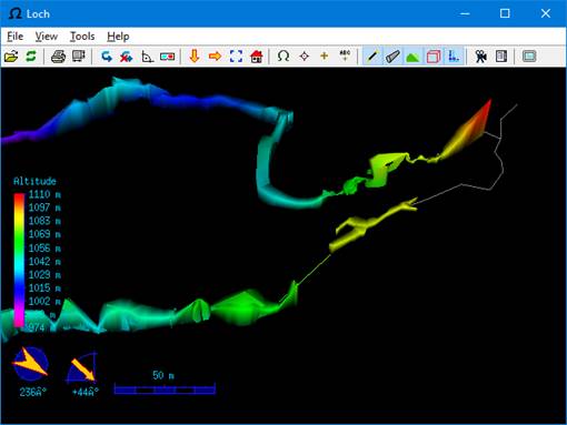
I think nosurvey will be the best compromise (when I can get the nosurveys to stop crashing the extended elevations).
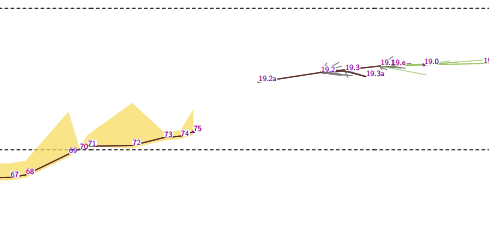
I fixed the crash, and got the extended elevation to work, as per the image below. Also figured out that if the nosurvey leg is not in any maps that are selected for export, then the nosurvey leg will not be output. Using nosurvey to join up disconnected surveys for extended elevations is no longer a hack! (but it's should be able to be distinguished more directly in outputs). Hmm, Is it possible to set it's visibility to off Bruce

On Sat, Apr 08, 2017 at 11:32:00AM +0200, Martin Sluka via Therion wrote:
8. 4. 2017 v 10:46, Bruce Mutton via Therion <therion@speleo.sk>:
Both options feel a little bit like hacks.
Nosurvey is nosurvey.
The thbook defers to the Survex manual for the definitions of the data styles ("See Survex manual for details.") and the Survex manual says: A NOSURVEY survey doesn't have any measurements - it merely indicates that there is line of sight between the pairs of stations. Adding NOSURVEY legs where there isn't a line of sight (or even a passage without an exact line of sight) is definitely a hack. Cheers, Olly
participants (4)
-
 Bruce Mutton
-
 guy.demars7@orange.fr
-
 Martin Sluka
-
 Olly Betts