Options for converting splays in my Cave Converter tool

As I am working on improving the handling of splays in my cave converter tool, I wanted to get the opinions of other surveyors as to what options are actually useful. Previously the cave converter automatically converted splays to LRUD dimensions for survey legs, removing the splays as it did so. This was because I came to DistoX surveying from traditional instruments where I typically only measured LRUD at stations. So my initial thoughts on splays were that they were just a way to measure these passage dimensions at each station. As I progressed in knowledge I came to realise the value of splays for marking key points to assist in sketching the shapes of chambers and interesting bends and shapes in passages, to mark side passages and key formations or other features. So I changed the converter to only remove the splays when just LRUD measurements were found at a station. This removed the masses of splays for long sections of simple passage, but retained them at interesting points where more splays were measured. Another few years on, and I am finally moving this LRUD generation code from the PocketTopo file parser into the general survey utility classes. So it will be possible to generate LRUD data from splays for any survey from any format read in. This is where my current questions arise. Which of the following options do people think are genuinely useful: 1) Remove all splays from the output survey file. 2) Keep all splays and also generate LRUD data for legs with stations which have splays. 3) Remove splays which are used to generate a passage dimension (one of LRUD), but keep the rest of the splays. 4) Remove splays when generating LRUD data only when there are no splays at a station other than those used to generate the LRUD data. Anything I missed? Feedback welcome. For anyone who is not familiar with my Cave Converter, the homepage for the tool is: http://wscc.darkgem.com/caveconverter/ Footleg

Footleg, I apologise myself, but try to read something about geodetic method tachymetry :) http://engineeringsurvey.blogspot.cz/2013/02/tachymetry.html Splay shots allow to survey cave and not only to paint it. It is very important. The same kind of importance as the cross-section on station isn't generaly rectangular. I think the LRUD method came from mine surveying, where it is +- right. m. Jul 18, 2013 v 9:27 PM, Footleg <drfootleg@gmail.com>:
Anything I missed?
Martin Sluka - Studio Sluka prodej Hahnemühle DFA tisk fotografií a reprodukcí Na Rovnosti 2692/21 130 00 Praha 3 tel.: +420 603513640 mail: martinsluka@mac.com web: http://www.piezografie.cz

Hi I would question the conversion of splays to LRUD. They were probably introduced because that was the best that could be done in a reasonable time frame while surveying underground. Now splays are taking over. They give more and better targeted information. LRUD always had major flaws like whether to take it perpendicular or as a perpendicular to the bisector of the previous and next leg (so what happens if there are 3 legs from a station) And junctions where always a real mess, then there are pitches, lots of times the readings where left blank. Maybe converting LRUD to splays is the way to go, but that would give splays that go through rock at times. I would see them as 2 types of data, would you convert dive data to normal data, possibly to move from one program to another? I personally would leave them as splays, hopefully software will catch up to allow models to be produced from the better data Andrew On 18/07/13 21:28, Martin Sluka wrote:
Footleg,
I apologise myself, but try to read something about geodetic method tachymetry :)
http://engineeringsurvey.blogspot.cz/2013/02/tachymetry.html
Splay shots allow to survey cave and not only to paint it. It is very important. The same kind of importance as the cross-section on station isn't generaly rectangular. I think the LRUD method came from mine surveying, where it is +- right.
m.
Jul 18, 2013 v 9:27 PM, Footleg <drfootleg@gmail.com <mailto:drfootleg@gmail.com>>:
Anything I missed?
Martin Sluka - Studio Sluka
prodej Hahnemühle DFA tisk fotografií a reprodukcí
Na Rovnosti 2692/21 130 00 Praha 3 tel.: +420 603513640 mail: martinsluka@mac.com <mailto:martinsluka@mac.com> web: http://www.piezografie.cz
_______________________________________________ Therion mailing list Therion@speleo.sk http://mailman.speleo.sk/mailman/listinfo/therion
On 18 July 2013 21:28, Martin Sluka <martinsluka@mac.com> wrote:
I apologise myself, but try to read something about geodetic method tachymetry :)
http://engineeringsurvey.blogspot.cz/2013/02/tachymetry.html
Splay shots allow to survey cave and not only to paint it. It is very important. The same kind of importance as the cross-section on station isn't generaly rectangular. I think the LRUD method came from mine surveying, where it is +- right.
Thanks for the link Martin. Finally I know what I should be doing after all these years ;) But my question was not 'What should I do with my data?', but 'What are the different useful things that anyone might want to do with their data?' Hold on to your seat now, as the following example features people doing things with survey data which does not always involve Therion! When drawing up a plan or elevation I agree the splays are almost always useful to retain completely. But there are some use cases where I might want to generate different models of my cave to aid visualisation. The first case is where someone is such a fan of splays (I recently had to fix a bug which occurred when more than 26 splays were present at a single station) that the 3D model of the cave is difficult to visualise because of the sheer number of splays. So it is useful to be able to generate a model without the splays present. The ideal would be a viewer which allows splays to be turned on or off, but I don't know of one. Loch appears to not show splays at all. Aven appears to always show splays. A second related case is where I have taken a backsight for every leg. I do this as a splay with the DistoX to check for problems in the measurement of that leg. But now I have a splay running along the line of every leg. In Aven when I view my model coloured by error these splays hide the colours of the legs in my loops because the splay is not in a loop and so appear white. Deleting the splays allows me to view my cave coloured by error very clearly. The ideal would be a way to indicate a leg is a backsight in the survey data file. But until that is implemented and the viewers allow it to be hidden I have to remove the splays for some views of my data. Now I want to view the relative passage sizes in Aven. So I need LRUD data to generate passage solid tubes. It is a crude approximation of the true passage shape and size, but definitely very useful. Hence the desire to generate LRUD data from the splays. I am not going to use it to draw up my maps, just to generate a half decent looking model. Why not use Therion and Loch to create the model (I can almost hear Martin asking!). Well until I have drawn all my scraps I do not get solid passages of the correct size. I think Loch makes up the passage dimensions based on the leg length of something. Certainly not using LRUD data or splays. I also cannot view my loop errors or survey coloured by date in Loch. Nor can I measure distances in the Loch viewer. Finally and possibly the most controversial use case. Someone has used their DistoX to measure orthogonal LRUD dimensions at each station, because this is how they have surveyed for years and having a new survey instrument does not change behaviour overnight. So they want the LRUD data to be extrapolated from these splay measurements. They don't want the splays left in their data file, so I have an option to remove any splay which was used to generate a passage dimension. I think all these are useful abilities in a tool which can process survey data. No single file format or viewer can do all the things I find useful, but my converter tool enables me to process my data to work around these issues. But what else do other people wish they could do which they would find useful, but which currently they can only achieve by painstaking hand editing of their survey data files? Footleg

Hi Footleg Although I have not used your software, and I don't imagine that will need it with my current workflow habits, that may not always be the case. I like the idea of what you are doing, and think those four options in your original post seem to have potential uses. Some comments from your recent post.
Loch appears to not show splays at all.
Loch does enable splays to be turned on and off. By default they are off, even if they are present in the data file. Right click, select 'scene', then 'centreline' and you can toggle splay visibility.
Why not use Therion and Loch to create the model (I can almost hear Martin
asking!). Well until I have drawn all my scraps I do not get solid passages of the correct size. I think Loch makes up the passage dimensions based on the leg length of something. Certainly not using LRUD data or splays. Not quite right. If you set 'walls auto' in your centrelines, (pg 20 5.3.11 Therion Book) Loch generates passage tubes; 1. by guess where you have no LRUD data 2. as per LRUD data where it exists 3. as per plan scrap drawings and 'point passage-height' or 'point dimensions' where they exist, and otherwise guesses for passage height My guess is that if UD data is present, Loch will superpose plan shape and realistic passage height - I have never tried it, so Footlegs option to generate UD data from splays will be interesting. The embedded image is case number 3 above. Bruce
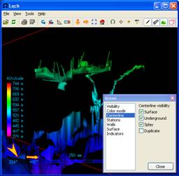
Thanks Bruce, I was not aware of that option to show/hide splays in Loch. I also never realised that lox models could generate passage walls using LRUD data. I had only seen it done using plan scraps and over-riding badly interpolated heights using ceiling height points in my scraps. Can I add LRUD data to my survey data in order to generate passage heights when the wall lines in my scraps are used to set the widths? This would be a good reason for me to accelerate support for Therion format reading and writing in Cave Converter. Then you will be able to generate LRUD data from splays to improve passage dimensions in models viewed in Loch. I'll find you a compelling reason to use this tool yet Bruce! Footleg
participants (4)
-
 Andrew Atkinson
-
 Bruce
-
 Footleg
-
 Martin Sluka